Approximate Location Map
Large Map »
This site is entirely user-supported. See how you can help.
Latitude: 57.2814 / 57°16'53"N
Longitude: -4.4461 / 4°26'46"W
OS Eastings: 252638
OS Northings: 823849
OS Grid: NH526238
Mapcode National: GBR H9DG.VJ1
Mapcode Global: WH3G6.N7ZT
Entry Name: Dun Deardail, forts 410m and 520m ENE of Fasnagruig
Scheduled Date: 21 February 2008
Source: Historic Environment Scotland
Source ID: SM11884
Schedule Class: Cultural
Category: Prehistoric domestic and defensive: fort (includes hill and promontory fort)
Location: Dores
County: Highland
Electoral Ward: Aird and Loch Ness
Traditional County: Inverness-shire
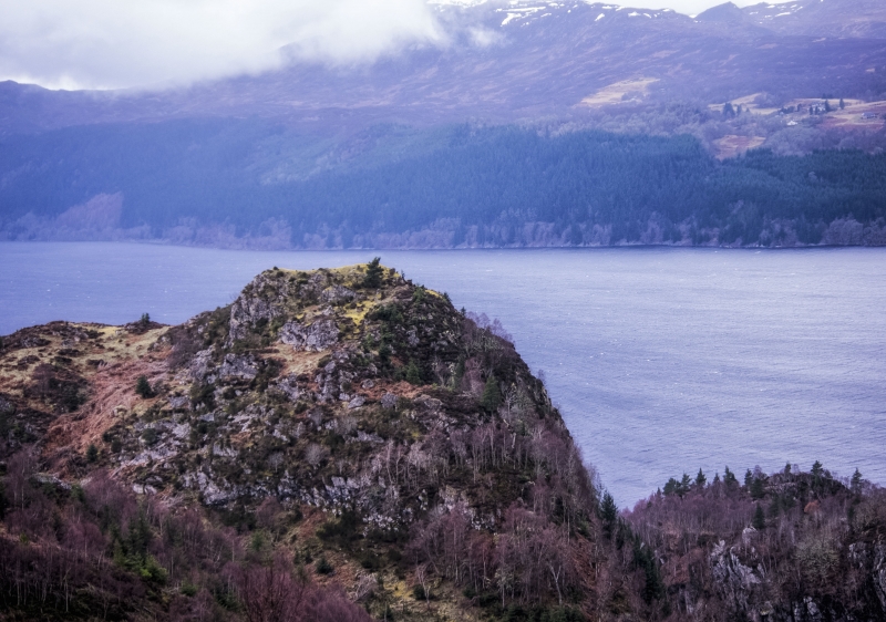
The monument comprises two Iron-Age forts and associated outworks situated adjacent to and on the summit of a hill to the E of Inverfarigaig Bridge, on the SE shore of Loch Ness.
The two forts lie 85 m apart on a hill named Dun Deardail, with the NE fort occupying the true summit knoll and the SE fort occupying a second peak on the broad ridge below. The NE fort is sub-rectangular on plan, measuring 32 m from NNE to SSW by a maximum of 20 m, with the flat summit surrounded by a turf-covered wall on average 0.8 m high. The footings of the outer wall face are visible laid on bare rock to the E, suggesting a wall thickness of around 5 m. Evidence of tumble on all sides implies the surrounding wall was substantial in height. Possible evidence of vitrification has been noted in the past at the NW corner. A lowering of the rampart suggests the entranceway lies to the SSE, with a damp depression at the lowest point of the interior at the SW corner being the suggested location of a cistern. No external features are identifiable, although antiquarian accounts indicate that traces of a rampart were once visible on the terrace below the fort to the E.
A saddle separates the SW fort from the NE fort, up to which a natural access ramp leads from the E. This ramp is the obvious place from which to make any ascent of the hill. The SW fort is roughly circular on plan, measuring 30 m NE to SW by 24 m, with an outer face of unhewn blocks surviving two courses high at 0.9 m around almost all of the periphery. In the interior, a line of blocks to the S may suggest an inner wall face, giving a wall thickness of around 4.7 m. The wall core has been robbed, and the interior is featureless, with no visible entrance.
To the SW of the SW fort we see a series of denuded outworks on the flank of the hill. Four sections exist, each consisting of a rubble spread. The best-preserved stretch runs from the break of slope on the NW to the break of slope on the SE, with coursing visible for a metre in its centre. At its SE end it converges with an outwork running SW to NE up the flank of the hill. A short outwork runs parallel to another well-preserved stretch about 15 m uphill, and at right angles to this section a rubble spread runs for a few metres SW to NE along the contours of the hill.
The area to be scheduled comprises two irregular polygons on plan, each centred on a fort, to include the remains described and an area around each fort within which evidence relating to its construction and use may survive, as shown in red on the accompanying map.
Source: Historic Environment Scotland
Cultural Significance
The monument's archaeological significance can be expressed as follows:
Intrinsic characteristics: Both the NE and SW forts are well preserved, each with their own defining field characteristics. The disparity in form between them may suggest functional or temporal differences. The NE fort, perched on the steep-sided summit, retains its well-defined sub-rectangular perimeter wall with a clear entranceway through it. Potential exists for evidence of vitrification remaining in place, as well as for deposits relating to the prehistoric environment to be preserved in the vicinity of the supposed cistern. The SW fort retains an almost complete outer wall, although little remains of the robbed rubble core. The apparent lack of entrance is an unusual characteristic given the high level of preservation across the site. The outworks across the SW flank of the hill are denuded yet clearly visible; the variety of direction and length suggests complexity or rebuild and reuse. A lack of cultivation across the whole site due to its topography, means that the potential for preservation of features relating to the construction and use of the forts is high.
Contextual characteristics: Situated so close together on the prominent hill, the forts command an extremely powerful location. Extensive views from Fort Augustus at the SW end of Loch Ness up towards Inverness in the NE mean that the forts have a strategic overview of any traffic using Loch Ness. It is likely that the two forts were roughly contemporary, given their close proximity and probable shared access up the natural ramp between them. However, we cannot rule out that one is consecutive to the other, given the variety in construction and form. It is also unclear whether the outworks on the SW flank belong to the SW fort alone or to the hilltop as a whole. In general, Iron-Age forts can be situated on rocky knolls for a variety of potential reasons: defence, availability of building material, visibility within the landscape or avoiding the usage of land that could otherwise be cultivated. Spatial analysis of these forts' location in relation to nearby Iron-Age forts and duns may enhance our understanding of the role of such structures, particularly in relation to society and economy. It is possible that a network of intervisible forts may exist along the length of Loch Ness. Comparison of these forts and outworks with others will enable a better understanding of the construction and form of Iron-Age drystone structures.
Associative characteristics: The forts have been recognised at least since the late 18th century, when in 1783 Tytler recounts both forts and describes the lower SW one as a 'Druidical Temple'. In the mid-19th century the NE fort appears on the Ordnance Survey Firstst Edition map, marked as a vitrified fort.
National Importance
The monument is of national importance because it is an excellent example of a pair of well-preserved Iron-Age forts with outworks, situated in a highly strategic location commanding views of an important coast-to-coast thoroughfare. Potential exists for the site to add to our understanding of the functional chronology of hill forts and outworks, and how this affects their morphology. The monument has the capacity to increase our awareness of site intervisibility, as well as the potential to provide well-preserved archaeological deposits within the interior of each fort and the surrounding terraces enclosed by the outworks. Its loss would impede our future ability to appreciate and understand the Iron-Age landscape and the lives of its inhabitants.
Source: Historic Environment Scotland
Bibliography
RCAHMS record the NE fort as NH52SW 2 and the SW fort as NH52SW 4.
Photographs:
RCAHMS, 1994: C 26006; C 26007; C 26008; C 26009; C 26010; B 85868 CS; B 85869 CS; C 26456 CN; C 26457 CN; C 26458 CN.
RCAHMS, 1998: D 24771; D 24772; D 24773; D 24774; D 24775.
References:
Ross A 1915, 'Dun-Dhearduil and Tor-Duin hill forts', TRANS INVERNESS SCI SOC FLD CLB, 7 1906-12, 18-23.
Tytler 1793, TRANSACTIONS OF THE ROYAL SOCIETY OF EDINBURGH, 14-15.
Wallace T 1910, 'Vitrified fort on Dundearduil', TRANS INVERNESS SCI SOC FLD CLB 6, 1899-1906, 188-91.
Source: Historic Environment Scotland
Other nearby scheduled monuments