Approximate Location Map
Large Map »
This site is entirely user-supported. See how you can help.
Latitude: 51.777 / 51°46'37"N
Longitude: -1.2997 / 1°17'58"W
OS Eastings: 448412.337026
OS Northings: 208937.0328
OS Grid: SP484089
Mapcode National: GBR 7XC.G7G
Mapcode Global: VHCXM.FL8L
Entry Name: Godstow Abbey: a Benedictine nunnery, associated earthworks, leats and bridge, immediately south of Godstow Bridge
Scheduled Date: 23 April 1949
Last Amended: 26 November 2004
Source: Historic England
Source ID: 1021366
English Heritage Legacy ID: 35542
County: Oxfordshire
Electoral Ward/Division: Wolvercote
Traditional County: Oxfordshire
Lieutenancy Area (Ceremonial County): Oxfordshire
Church of England Parish: Wolvercote
Church of England Diocese: Oxford
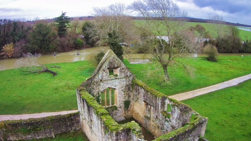
The monument includes the standing and buried remains of Godstow Abbey, a
12th century Benedictine nunnery with associated water and drainage channels,
earthworks and a bridge. The abbey stands on the west bank of the Thames,
west of Wolvercote village, on an island formed by watercourses which leave
the Thames to the north of the Abbey and run southwards to form the western
precinct boundary. These watercourses continue south to join Wytham stream,
but another strikes off at a right angle, heading north east to rejoin the
river just to the south of the small field known as Godstow Holt: this lies
just beyond the southern boundary of the scheduling.
The nunnery was founded by Ediva, or Edith, widow of Sir William Launcelene,
probably in 1133. According to legend, after living a holy life at Binsey for
some time, she was bidden by a voice to go to where a light from heaven
touched the earth, and there to establish a house for 24 of the `moost
gentylwomen' that she could find. The story tells that the light fell at
Godstow, and so it was here, with the aid of an endowment from Henry I, that
the nunnery was built: it was dedicated in 1139. The nunnery was to hold
lands in many counties, becoming, with Elstow, near Bedford, one of only two
nunneries north of the Thames comparable in wealth to some of the great
Anglo-Saxon foundations of Wessex and the south.
Following the Dissolution of the Monasteries, the land was sold and the
nunnery buildings converted to domestic use. They were lived in until the
Civil War, but on 23rd May 1645 they were burnt down and subsequently in
greater part demolished. However, some of the buildings survived into the
18th century, including the church tower, which blew down in a gale in 1764.
In 1690, the antiquarian, Anthony Wood, was given a guided tour of the
remaining abbey buildings. His account and sketch plan have become the basis
of all subsequent interpretations.
Wood describes two main courts, the claustral range, with the nuns' lodgings
and offices, and the `Guest Court' to the north. The church lay between the
two, attached to the north side of the cloister, but accessible to local
people through the Guest Court. Of this court, and of the church, no standing
remains survive. The claustral buildings are represented only by walls
standing on the north, south and east sides, and in part on the west side.
There is also a small private chapel standing to roof height in the south
east corner. The claustral enclosure measures about 70m north-south and 56m
east-west. At their highest the walls stand to between 3m and 4m. Although
little remains in the way of architectural detail, the south, east and west
walls appear to be part of the original construction, but the north wall,
which contains a wide modern double gated entrance, seems to have been
largely rebuilt. The walled enclosure remained in agricultural use until
recent times, with sheds at the north west and south west corners.
The small two storey building in the south east corner of the claustral
enclosure, possibly the abbess' chapel, is the only building remaining from
the nunnery's domestic ranges. Anthony Wood's representation of this
corresponds in almost all details with the way it looks today. The chapel is
entered at ground level through a door at the west end of the north wall.
Joist holes and beam slots in the walls at the west end of the building
indicate an upper floor or gallery at this end only. Access to this was
through a doorway immediately above the ground level door. Also at this upper
level, but at the east end of the north wall, is a squint angled to allow a
view of the altar and east end of the chapel from outside. Both these
features, the upper level door and the squint, suggest the existence of
either an upper storey corridor from a south range, or of an east range
extending north from the chapel.
Immediately to the north of the chapel at ground level there is a small
blocked arched door in the east wall, visible only from the outside, which
would have given direct access from outside the cloisters to the nuns'
domestic ranges. Wood says that the nuns' lodgings stood `some distance' from
the chapel, and his plan shows three houses on the west side of the
quadrangle. He describes a cloister as connecting the two, of which traces
remained in 1690. The ground level is higher in the southern half of the
quadrangle, sloping away gently to the north, perhaps indicating the buried
remains of a domestic south range, incorporating this cloister, connecting
the nuns' lodgings with the chapel.
The nunnery's water supply may have come from a well located just south of
the centre of the quadrangle. However, this well is brick lined and has a
modern water pipe protruding from the top, suggesting its use into recent
times: nothing in its superficial appearance indicates a medieval origin and
its date of construction is unknown. However, from the time of its foundation
the nunnery received a supply of fresh water, channelled in from a source
outside the walls. In 1135 a site near Wytham for a collecting reservoir was
granted to Godstow, with leave to construct a connecting pipe. This source
has not been identified, and the surviving conduit, a stone lined channel,
can now be seen to have carried water into the nunnery from the Thames. The
water supply originated about 250m to the north where a watercourse leaves
the Thames, forming several branches, of which the nunnery conduit is one.
About 200m downstream it is crossed by a single span stone arched bridge
carrying the old Wolvercote to Wytham road and is thought to be medieval.
From this point the conduit is evidently stone lined. It continues south for
a further 50m before turning east, running another 100m before it enters the
cloisters at the south west corner through an arched culvert, now blocked. It
ran beneath the cloister quadrangle where it can be seen as a slight
depression running from west to east on the south side. Waste from the
conventual buildings was then discharged into the river immediately to the
east of the nunnery. Another, wider, watercourse runs parallel with this
conduit from north to south, about 15m to the west: this appears to form the
western precinct boundary.
The stone lined conduit forms the south and west boundaries of a third
courtyard, known as Sanctuary Field: this lies to the west of the cloisters.
The north boundary of this courtyard is formed by a wall built of rough uncut
limestone, supported on the inside by two modern concrete buttresses: its
appearance is quite different to the other walls of the nunnery. There are
slit openings at intervals along its length which suggest it may have been a
Civil War defensive structure, evidence of the role played by the abbey in
the siege of Oxford during the Civil War. Observations made after ploughing
in 1971 record that the field was spread with tile and stone, possibly the
result of the burning and subsequent demolition of the buildings that took
place after the siege of Oxford.
The main entrance to the nunnery's cloister was from the Guest Court to the
north, through a wide gate in the north west wall. The surviving entrance,
now blocked, which can be seen clearly only from the outside, dates to the
late 15th or early 16th century. There are no visible remains of the double
doored gatehouse with lodgings over described by Wood, or of the range of
buildings extending the length of the north side of the Guest Court,
including another chapel. These buildings were probably occupied by male and
lay attendants to the nuns, including the gatekeeper, and by pensioners who
had bought a lifetime's residence in return for grants of land. Excavations
in 1959 in advance of construction of the new Wolvercote to Wytham road
revealed the foundations of at least two phases of buildings dated to the
12th and 13th centuries, as well as a substantial boundary wall. Walls were
also observed in electricity trenches cut to the north of the road in 1994.
Also within the Guest Court, and just outside the main gate to the cloister,
lying between the Sanctuary field wall and the road, is an irregular, roughly
oval depression measuring about 30m by 10m. This is generally described as a
fishpond, but its shape and location within the Guest Court make this
unlikely: it has more the appearance of later quarrying.
Wood's drawing includes a plan of the church, which he shows as a simple
nave, with no transepts, side aisles or chapels, a plan common to conventual
churches. The tower still survived in 1690, and is shown offset from the
nave, but attached at its north west corner: there was a door from the tower
giving access to the church for the lay congregation. He also drew a `pair of
folding gates from the nunnery' immediately to the south of this,
corresponding with the position of the modern double gated entrance to the
enclosure in the north wall.
The graveyard to the east of the church was identified when several coffins
were recorded during the construction of a new channel to the Thames in 1780,
about 30m from the cloister wall; in 1885, when the cut was widened, a
further 25 coffins were found. At that time the towpath was raised by about
0.9m. In 1973, when the towpath was rebuilt, tiles were observed, and about
three of the coffins re-buried in 1885 were uncovered. There have been
further finds of floor tiles and tiled pavements on the riverbank throughout
the 19th and 20th centuries: these may belong to the chapter house, or to
other extramural buildings.
About 20m to the south and on the same alignment as the cloisters there is an
earthwork enclosure measuring about 100m east-west, and 65m north-south,
defined by ditches on the west and south sides. On the north side the ditch
seems to have been infilled, and appears as a darker green band in the
pasture. Lying within, and partially overlying this are three arms of another
narrow rectangular ditched enclosure, 70m east-west and 30m north-south, with
a narrow causeway at the south west corner. All three remaining west-east
ditches extend under the footpath to the east and fade out towards the Thames
towpath. To the west there are other less well-defined earthworks. A further
20m to the south is another small ditched enclosure, about 35 sq m. This is
subdivided into three sections by slight traces of internal ditches. Its
south east corner is clipped by the raised garden to the lock keeper's
cottage, which is not included in the scheduling.
About 60m further south a boundary ditch about 5m wide runs from the
watercourse on the west in a straight line and heads north east to the river:
this ditch is banked on both sides, and may represent the nunnery precinct's
southern boundary. To the south of this is a small field known as Godstow
Holt, which contains low ridge and furrow running from south west to north
east. This is bounded on the south by another ditch, which forms the southern
boundary of the scheduling. This field is an integral part of the present day
abbey grounds and landscape. It is also assumed to be part of the nunnery's
immediate agricultural holdings, and for that reason is included in the
scheduling. The scheduling is therefore designed to protect the upstanding
remains (which are also Listed Grade II) and buried remains that lie within
the precinct, as well as a fragment of the abbey's wider landscape, the ridge
and furrow to the south. The watercourses and ditches that form the precinct
boundaries are included in the scheduling.
All modern road and track surfaces and the raised towpath, the Thames Bridge,
all modern water pipes, fences and gates, and the scaffolding parapet on the
single-arched bridge are excluded from the scheduling, although the ground
beneath all these features is included.
MAP EXTRACT
The site of the monument is shown on the attached map extract.
Source: Historic England
A nunnery was a settlement built to sustain a community of religious women.
Its main buildings were constructed to provide facilities for worship,
accommodation and subsistence. The main elements are the church and domestic
buildings arranged around a cloister. This central enclosure may be
accompanied by an outer court and gatehouse, the whole bounded by a precinct
wall, earthworks or moat. Outside the enclosure, fishponds, mills, field
systems, stock enclosures and barns may occur. The earliest English nunneries
were founded in the seventh century AD but most of these had fallen out of use
by the ninth century. A small number of these were later refounded. The tenth
century witnessed the foundation of some new houses but the majority of
medieval nunneries were established from the late 11th century onwards.
Nunneries were established by most of the major religious orders of the time,
including the Benedictines, Cistercians, Augustinians, Franciscans and
Dominicans. It is known from documentary sources that at least 153 nunneries
existed in England, of which the precise locations of only around 100 sites
are known. Few sites have been examined in detail and as a rare and poorly
understood medieval monument type all examples exhibiting survival of
archaeological remains are worthy of protection.
Godstow Abbey was a significant medieval foundation, and although none of the
main buildings remain standing, enough survives, when taken with the
substantial documentary evidence and the results of excavation, to indicate
its form. The abbess' chapel in the south east corner survives in good
condition, and excavations have demonstrated the survival of buried walls and
other features within the area of the Guest Court. It will be possible to
trace the extent of buildings both within and to the north of the claustral
enclosure. Discoveries made over the last 200 years have also demonstrated
the survival of tiled floors and burials to the east of the conventual
buildings. The boundary ditches to the west and south may contain waterlogged
environmental deposits, providing evidence of contemporary land use within
and beyond the abbey precinct. The buildings and buried remains will also
retain evidence of the nunnery's later conversion to secular domestic use,
its role in the defence of Oxford during the Civil War, and its subsequent
destruction.
Godstow was part of a network of monastic houses both within and without
Oxford's city walls. The nunnery's nearest monastic neighbour is Wytham
Abbey, to the west, although there may have been an early conventual
settlement at Binsey, to the south. The economic life of the nunnery and the
nun's domestic arrangements are well-documented, and it may be possible to
relate these to the physical remains of the nunnery.
The extensive abbey grounds have considerable landscape and amenity value. A
footpath, part of the long distance Thames Path, and a towpath lie to the
east of the nunnery.
Source: Historic England
Other nearby scheduled monuments