Approximate Location Map
Large Map »
This site is entirely user-supported. See how you can help.
Latitude: 54.2155 / 54°12'55"N
Longitude: -2.7669 / 2°46'0"W
OS Eastings: 350088.580425
OS Northings: 480240.05695
OS Grid: SD500802
Mapcode National: GBR 9M3P.SM
Mapcode Global: WH83G.G9PQ
Entry Name: Cappleside Hall medieval lordly residence 600m north east of Beetham House
Scheduled Date: 24 February 2004
Source: Historic England
Source ID: 1021184
English Heritage Legacy ID: 35022
County: Cumbria
Civil Parish: Beetham
Traditional County: Westmorland
Lieutenancy Area (Ceremonial County): Cumbria
Church of England Parish: Beetham St Michael and All Angels
Church of England Diocese: Carlisle
The monument includes the upstanding and buried remains of Cappleside Hall
medieval lordly residence located between Pool Darkin Lane and Paradise
Lane on the sheltered eastern flank of Cappleside Hill 600m north east of
Beetham House. It consists of a substantial masonry wall with surrounding
associated earthworks.
It is not known when construction of Cappleside Hall began. The earliest
documentary reference to Cappleside, then known as Capplesheved, dates to
1336 when it formed part of the manor of Beetham. In 1348 Richard, son of
Henry de Capplesheved, was sergeant to Ralph de Beetham, lord of the manor
of Beetham. This suggests that Cappleside may have been an important
holding within Beetham by this time. The earliest reference to Cappleside
as a manor occurs in 1523 when it was in possession of the Middleton
family. During the 17th century the manor passed to the families of
Buskills, Prestons and Cliffords. The earliest specific reference to the
hall occurs in 1691 but it may already have been abandoned by that time as
it had been allowed to become partially ruinous by the Clifford family.
The hall was largely demolished during the 18th century but one wing
survived and in 1763 this was converted into a barn by a local farmer.
Five years later the barn, along with the rest of Cappleside manor was
sold to the Dallam estate. By 1867 this barn had also fallen into ruin.
The antiquarian William Hutton visited Cappleside Hall in the 1760s and
described the building as a central hall with two projecting service
wings, each of three storeys. Hutton's measurements of the building
indicate that Cappleside was the fourth largest medieval hall in
Cumberland and Westmorland.
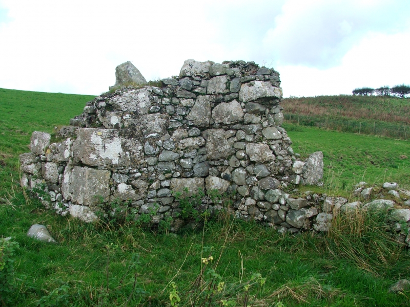
The upstanding remains include a fragment of medieval fabric which was
converted for agricultural use in the 18th century. It comprises part of
the hall's three storey service wing measuring up to 1.5m high and 1m
thick. Two projecting turrets on the south side of this fragment are
interpreted as the remains of a garderobe chute and a fireplace. The
remainder of the medieval hall survives as well-defined earthworks partly
obscured by later earthworks relating to enclosures associated with the
barn. All these earthworks are best seen on aerial photographs.
All modern walls, gateposts, fences, fenceposts, a corrugated iron shed
and wooden posts holding what appear to be containers are excluded from
the scheduling, although the ground beneath these features is included.
MAP EXTRACT
The site of the monument is shown on the attached map extract.
Source: Historic England
Medieval rural settlements in England were marked by great regional diversity
in form, size and type, and the protection of their archaeological remains
needs to take these differences into account. To do this, England has been
divided into three broad Provinces on the basis of each area's distinctive
mixture of nucleated and dispersed settlements. These can be further divided
into sub-Provinces and local regions, possessing characteristics which have
gradually evolved during the past 1500 years or more.
This monument lies in the Lancashire Lowlands sub-Province of the Northern and
Western Province, an area extending from the moorlands of the western Pennines
to the coastal plain with its villages and hamlets. The southern part of the
sub-Province supports high densities of dispersed settlements, but there are
much lower densities further north, in the Craven Lowlands, the Ribble Valley
and the areas around Morecambe Bay. In the Middle Ages the larger, lowland
settlements were supported by `core' arable lands, communally cultivated, with
enclosed fields around them. The uplands contained sheep and cattle farms and
seasonally occupied `shieling' settlements.
Most villages included one or more high status residences typically owned
by a Lord of the Manor. In the medieval period these prestigious
residences generally included a great hall, private chambers, kitchens,
stores and service rooms, frequently housed in a series of separate
buildings or ranges, sometimes arranged around one or more courtyards.
Lordly residences were also often the centre of the lord's home farm and
would thus include one or more barns and other structures like granaries
and buildings for livestock. They were often sited next to the parish
church or included a chapel which in some places became a parish church at
a later date. Sometimes the outer boundary of the complex of buildings
making up the lordly residence was defined by a wall, bank or ditch. Those
lordly residences defined by a substantial ditch are normally identified
as moated sites. Fish ponds, dovecots and mill sites are also often
associated with lordly residences, although often placed beyond the
boundary of the main concentration of buildings. Lordly residences may
survive as visible remains as well as below ground deposits. They were
important foci of medieval rural life as typically the Lord of the Manor
closely regulated local agricultural and village life. Towards the end of
the medieval period, this form of lordly residence with its scatter of
separate buildings was increasingly replaced by larger, more comfortable
houses, often set apart from the core of the village itself.
Cappleside Hall is known to have been the fourth largest medieval hall in
Cumberland and Westmorland. Despite being largely demolished the
upstanding and buried remains of the hall survive reasonably well and will
contain important archaeological information relating to the medieval and
early post-medieval occupation of this class of monument.
Source: Historic England
Other
In Cumbria SMR 10902, Cumbria County Council, Cappleside Hall,
In Cumbria SMR 10902, Newman,R., A Note on Cappleside Hall, (2003)
Source: Historic England
Other nearby scheduled monuments