Approximate Location Map
Large Map »
This site is entirely user-supported. See how you can help.
Latitude: 54.259 / 54°15'32"N
Longitude: -2.7525 / 2°45'9"W
OS Eastings: 351075.6825
OS Northings: 485076.0192
OS Grid: SD510850
Mapcode National: GBR 9M66.W0
Mapcode Global: WH838.P6HT
Entry Name: Hincaster Tunnel horse path
Scheduled Date: 6 February 1979
Source: Historic England
Source ID: 1004594
English Heritage Legacy ID: CU 528
County: Cumbria
Civil Parish: Hincaster
Traditional County: Westmorland
Lieutenancy Area (Ceremonial County): Cumbria
Church of England Parish: Heversham St Peter
Church of England Diocese: Carlisle
Horse path, from 60m south east to 375m east of Canal Cottage.
Source: Historic England
This record was the subject of a minor enhancement on 31 March 2016. This record has been generated from an "old county number" (OCN) scheduling record. These are monuments that were not reviewed under the Monuments Protection Programme and are some of our oldest designation records.
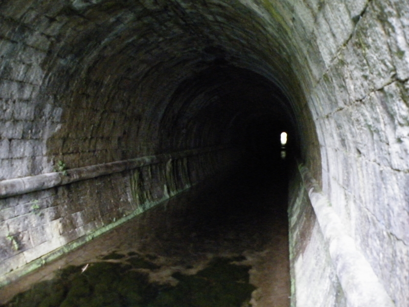
The monument includes a horse path of post-medieval date, which traverses Tunnel Hill along a broadly east-west alignment. The path includes a 2m to 3m wide hollow way with walls on either side stretches for approximately 370m between fields. The depth of the hollow way necessitated a series of accommodation bridges along its route to allow passage between the fields on either side. One such bridge lies at the top of the rise and is 1.5m wide and approximately 4.5m long. The horse path was built in conjunction with the Hincaster tunnel, which was constructed from 1813 to 1819 to allow the Lancaster Canal to pass under Tunnel Hill. The tunnel had no towpath so that horses had to be led over the hill to the other side, hence the path was constructed. Further archaeological remains survive in the vicinity of the monument, but these have not been included as they have not been assessed.
Source: Historic England
Canals are artificial waterways constructed primarily for navigation purposes and as such they differ from river navigations which were improvements to existing waterways to make them easier to navigate. Although the advantages of canals and inland waterways had long been recognised in Europe as an inexpensive means of transporting heavy and bulky goods and the safest way of carrying fragile ones, the golden age of canal building in England only began in 1759 with the construction of the Bridgewater Canal from Worsley to Manchester. Constructed by James Brindley and opened in 1761, the Bridgewater Canal carried coal from the Duke of Bridgewater's mines at Worsley, 7 miles (about 11km) to Manchester at less than half the cost of the traditional packhorse method. Over the next 70 years canals played an important part in the growth of industry and the expansion of trade in many parts of the country; in particular in the cotton, woollen, mining and engineering industries of Lancashire and West Yorkshire, in the growth of the Staffordshire pottery industry with its new water connection to the River Mersey and the port of Liverpool, and in the huge industrial expansion of Birmingham which, as the hub of the inland waterways system, rose to become England's second most prosperous city. Additionally canals also facilitated the relatively rapid movement of bulk agricultural produce from the countryside to the rapidly expanding industrial towns of the North and Midlands. Canal construction also brought with it the requirement for a whole range of associated structures. Many of these, such as bridges, canal worker's houses, warehouses, wet docks, dry docks, locks and water management systems involved the modification and development of the existing designs of such structures to meet the new requirements of the canal age. Additionally the canal age also introduced the need for major technological innovation in, amongst other things, the construction of tunnels and aqueducts, and the development of inclined planes and boat lifts. The great age of canals lasted until about the 1840s, after which the huge expansion in railways and their subsequent quick and cheap transportation of people and goods led to the rapid demise of canal usage. During their relatively brief lifespan of construction and heavy usage canals became the most important method of industrial transportation and provided a major contribution to the rise of the Industrial Revolution in England. The surviving remnants of the early industrial waterways transport network are particularly important both by virtue of their rarity and representivity.
The horse path which stretches from 60m south east to 375m east of Canal Cottage is reasonably well-preserved. The path forms part of the wider remains of Lancaster Canal and provides insight into the varied engineering responses required to carry water ways through varied terrain.
Source: Historic England
Other
PastScape Monument No:- 43111
Source: Historic England
Other nearby scheduled monuments