Approximate Location Map
Large Map »
This site is entirely user-supported. See how you can help.
Latitude: 53.3361 / 53°20'9"N
Longitude: -0.2803 / 0°16'49"W
OS Eastings: 514607.203119
OS Northings: 383509.952788
OS Grid: TF146835
Mapcode National: GBR VYHV.3T
Mapcode Global: WHHJV.NDQT
Entry Name: Medieval settlement, watermill and cultivation remains, East Torrington
Scheduled Date: 4 February 1999
Source: Historic England
Source ID: 1018903
English Heritage Legacy ID: 22755
County: Lincolnshire
Civil Parish: Legsby
Traditional County: Lincolnshire
Lieutenancy Area (Ceremonial County): Lincolnshire
Church of England Parish: East Barkwith St Mary
Church of England Diocese: Lincoln
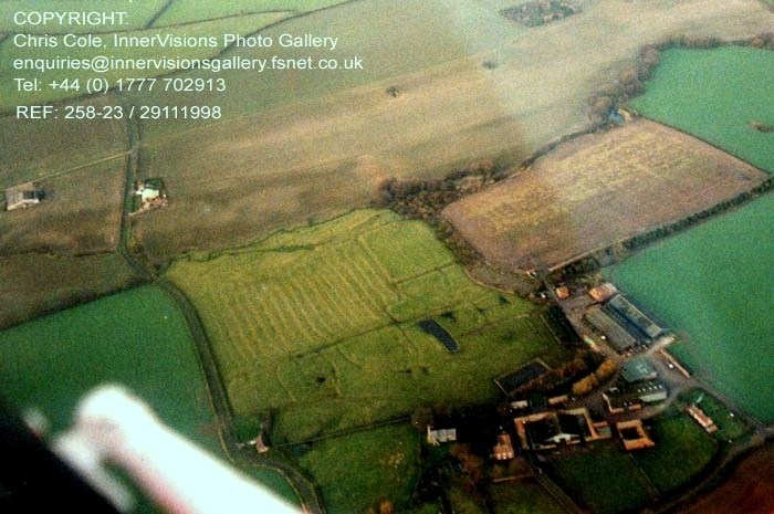
The monument includes the remains of the medieval village of East Torrington,
together with those of its associated fields and watermill complex. The
settlement had become established by the late 11th century when there were at
least 12 households in existence. The population gradually increased through
the Middle Ages but declined after the later 17th century when the open fields
were enclosed. By the mid-19th century, when the church and manor house were
rebuilt, most of the village had been abandoned. The church and churchyard are
in ecclesiastical use and are therefore not included in the scheduling; the
area of the manor house and farmyard is also not included.
The remains take the form of a series of earthworks extending to the north,
west and south of the present church and manor at East Torrington. Running
westward from the north side of the churchyard is a broad depression up to 1m
in depth, representing the remains of the principal east-west road through the
village; extending from the north side of this hollow way are a series of
ditched enclosures representing the remains of house plots and animal
enclosures. This series of earthworks, which is bounded on the north by a
linear depression marking a back lane of the village, together with the church
and manor sites to the south of the main hollow way, is believed to represent
the core of the early settlement. Pottery fragments found in this area suggest
that it may overlie remains of Roman date, and they are in turn partly
overlain by a modern pond and raised trackway.
Adjacent to the north west of these settlement remains is an area of ridge and
furrow cultivation, surviving up to 0.5m in height, representing a furlong of
the village's formerly extensive open fields. Immediately to the east of the
surviving furlong, in the north eastern part of the monument, are two large
ditched enclosures, the northernmost of which overlies earlier ridge and
furrow remains. These enclosures, together with those at the western end of
the village, are believed to indicate the expansion of the settlement over
parts of the earlier fields, probably in the later Middle Ages.
At the northern edge of the monument, adjacent to the west-flowing stream, is
a series of substantial earthworks representing the remains of a watermill
complex. In the north eastern corner of the monument are the remains of a
large embanked pond of rectangular shape, measuring approximately 100m by 20m.
This pond is believed to have been constructed in the medieval period on the
former course of the stream, where it served to build up a head of water to
power a mill. The buried remains of the watermill are believed to be situated
in the dam at the western end of the pond, where a depression marks the
position of the wheelpit. Extending westward from the site of the mill is a
linear channel representing an outlet leat, which, at the northwestern corner
of the monument, rejoins the earlier course of stream which is represented
here by the remains an irregular channel. The outlet leat is in turn joined
by a bypass leat which runs northwestwards from the north side of the pond,
where a sluice would have been situated in order to control the water level
within the pond. The banks around the pond have been partly breached in post-
medieval and modern times in association with drainage and extraction
activities.
On the south side of the main hollow way, immediately to the west of the
churchyard, are further earthwork remains of the village including a wet
depression marking a former pond. Extending southwards and eastwards from the
churchyard the earthworks include the remains of house plots which were
occupied in post-medieval and early modern times. Those in the south eastern
part of the monument, which include the surviving parts of the medieval
manorial enclosure, are in a separate area of protection. The remainder of the
manor site has been altered by the construction of the present house, farmyard
and buildings and is not therefore included in the scheduling.
All fences and gates are excluded from the scheduling, although the ground
beneath them is included.
MAP EXTRACT
The site of the monument is shown on the attached map extract.
Source: Historic England
Medieval rural settlements in England were marked by great regional diversity
in form, size and type, and the protection of their archaeological remains
needs to take these differences into account. To do this, England has been
divided into three broad Provinces on the basis of each area's distinctive
mixture of nucleated and dispersed settlements. These can be further divided
into sub-Provinces and local regions, possessing characteristics which have
gradually evolved during the last 1500 years or more.
This monument lies in the Lincolnshire Scarp and Vale sub-Province of the
Central Province, which comprises a succession of scarps and vales in which
clay vales with alluvial deposits and a chalk ridge, together with associated
glacial deposits, form the structural framework of the landscape. There is a
very dense scatter of nucleated settlements, many of which are situated in
lines along favoured scarp-foot and dip-slope locations. Large numbers of
medieval village sites now lie wholly or partially deserted. Densities of
dispersed farmsteads are very low.
The Scarp and Vale Country local region is divided by the Lincoln Edge from
the broad Vale of Trent to the west. Chains of ancient village settlements,
some now deserted, are characteristic of the region. They occur where soils
change and springs appear. Densities of dispersed farmsteads are uniformly
low.
Medieval villages were organised agricultural communities, sited at the centre
of a parish or township, that shared resources such as arable land, meadow and
woodland. Village plans varied enormously, but when they survive as
earthworks their most distinguishing features include roads and minor tracks,
platforms on which stood houses and other buildings such as barns, enclosed
crofts and paddocks. They frequently included the parish church within their
boundaries, and as part of the manorial system most villages included one or
more manorial centres. Villages were the most distinctive aspect of medieval
life in central England and their archaeological remains are one of the most
important sources of understanding about rural life in the five or more
centuries following the Norman conquest.
Medieval settlements were supported by a communal system of agriculture based
on large, unenclosed open arable fields. These large fields were subdivided
into strips (known as lands) which were allocated to individual tenants. The
cultivation of these strips with heavy ploughs pulled by oxen-teams produced
long, wide ridges, and the resultant ridge and furrow where it survives is
the most obvious physical indication of the open field system. Individual
strips or lands were laid out in groups known as furlongs, which were in turn
grouped into large open fields. Well-preserved ridge and furrow, especially
in its original context adjacent to settlement earthworks, is both an
important source of information about medieval agrarian life and a distinctive
contribution to the character of the historic landscape.
The medieval village at East Torrington, and the remains of its open field
system, survive well as a series of earthworks and buried deposits. As a
result of detailed archaeological survey and historical research they are
quite well understood. The remains of house plots and hollow ways will
preserve valuable evidence for domestic and economic activities on the site,
giving an insight into the lifestyle of the inhabitants and the way in which
the settlement evolved through the medieval, post-medieval and early modern
periods. The association of the village remains with those of its open fields
and watermill will also preserve evidence for the economy of the village and
its place in the wider medieval landscape.
Source: Historic England
Other nearby scheduled monuments