Approximate Location Map
Large Map »
This site is entirely user-supported. See how you can help.
Latitude: 51.0035 / 51°0'12"N
Longitude: -0.9208 / 0°55'14"W
OS Eastings: 475815.83773
OS Northings: 123237.680394
OS Grid: SU758232
Mapcode National: GBR CCB.201
Mapcode Global: FRA 86YG.K2F
Entry Name: Bell barrow 300m north east of the Club House on Petersfield Heath Common, part of the Petersfield Heath Group
Scheduled Date: 18 July 1932
Last Amended: 4 February 1999
Source: Historic England
Source ID: 1016446
English Heritage Legacy ID: 32526
County: Hampshire
Civil Parish: Petersfield
Built-Up Area: Petersfield
Traditional County: Hampshire
Lieutenancy Area (Ceremonial County): Hampshire
Church of England Parish: Petersfield St Peter
Church of England Diocese: Portsmouth
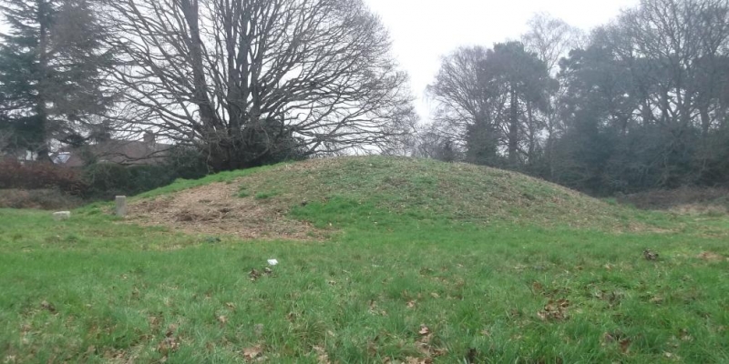
The monument includes a bell barrow of Bronze Age date situated on low lying
ground at the northern margin of Petersfield Heath Common, alongside Heath
Road. It forms part of a round barrow cemetery east of Heath Pond, known as
the Petersfield Heath Group. Now comprising a total of 21 barrows, a first
edition Ordnance Survey map dated to 1810 indicates that this round barrow
cemetery was formerly more extensive, including further barrows situated to
the north and east, now destroyed by modern housing.
The barrow mound is flat-topped, roughly circular in shape, and stands
approximately 2.6m high with an east-west diameter of 44m. It includes a
sloping berm, 8m-12m wide, around the south side, but has been clipped to the
north by the verge of Heath Road. A surrounding ditch and bank has also been
partly destroyed to the north by the construction of the road, but survives on
the east, south and south west as a ditch, 4m wide and 0.3m deep, and an outer
bank, approximately 6m wide and 0.3m high.
The modern boundary fence that crosses the monument is excluded from the
scheduling, although the ground beneath it is included.
MAP EXTRACT
The site of the monument is shown on the attached map extract.
Source: Historic England
Round barrow cemeteries date to the Bronze Age (c.2000-700 BC). They comprise
closely-spaced groups of up to 30 round barrows - rubble or earthen mounds
covering single or multiple burials. Most cemeteries developed over a
considerable period of time, often many centuries, and in some cases acted as
a focus for burials as late as the early medieval period. They exhibit
considerable diversity of burial rite, plan and form, frequently including
several different types of round barrow, occasionally associated with earlier
long barrows. Where large scale investigation has been undertaken around them,
contemporary or later "flat" burials between the barrow mounds have often been
revealed. Round barrow cemeteries occur across most of lowland Britain, with a
marked concentration in Wessex. In some cases, they are clustered around other
important contemporary monuments such as henges. Often occupying prominent
locations, they are a major historic element in the modern landscape, whilst
their diversity and their longevity as a monument type provide important
information on the variety of beliefs and social organisation amongst early
prehistoric communities. They are particularly representative of their period
and a substantial proportion of surviving or partly-surviving examples are
considered worthy of protection.
Bell barrows are the most visually impressive form of round barrow, and date
to the Early to Middle Bronze Age with most belonging to the period 1500-1100
BC. They are rare nationally with less than 250 known examples. The bell
barrow on Petersfield Heath Common, 300m north east of the Club House,
survives well despite some later disturbance by a modern road and the use of
the area as a public recreation ground. This and other barrows in the group
can be expected to retain important archaeological remains and environmental
evidence relating to the cemetery and the environment in which it was
constructed.
Source: Historic England
Books and journals
Grinsell, L V, 'Proceedings of the Hampshire Field Club' in Hampshire Barrows, , Vol. 14, (1939)
Source: Historic England
Other nearby scheduled monuments