Approximate Location Map
Large Map »
This site is entirely user-supported. See how you can help.
Latitude: 52.6353 / 52°38'7"N
Longitude: -2.5312 / 2°31'52"W
OS Eastings: 364145.877533
OS Northings: 304308.07556
OS Grid: SJ641043
Mapcode National: GBR BT.73JR
Mapcode Global: WH9DG.21Y0
Entry Name: Buildwas Abbey
Scheduled Date: 8 February 1915
Last Amended: 14 March 1997
Source: Historic England
Source ID: 1015813
English Heritage Legacy ID: 27545
County: Shropshire
Civil Parish: Buildwas
Traditional County: Shropshire
Lieutenancy Area (Ceremonial County): Shropshire
Church of England Parish: Buildwas Holy Trinity
Church of England Diocese: Lichfield
The monument includes the ruined and buried remains of Buildwas Abbey and the
earthwork and buried remains of an extensive water management system,
including water meadows, leats, fishponds, mills, and a fish weir, as well as
the remains of several charcoal burning hearths. The abbey, which is situated
on the south bank of the River Severn west of Buildwas Bridge, was founded for
the Savignac order in 1135, by Roger de Clinton, Bishop of Lichfield. It was
dedicated to Our Lady and St Chad, and became Cistercian when Savigny was
united with that order in 1147. No evidence for permanent buildings earlier
than the 1150s has been found, and the abbey first appears to have prospered
under the energetic rule of Abbot Ranulf, between 1155-1187. The church,
chapter house, and cloisters were probably built during his abbacy, and over a
dozen of the library's 40 books were written in the 12th century.
Buildwas remained a modest house, but its 400 year history was punctuated by
periodic drama, not least because of its politically sensitive location near
the Welsh border, and its having administrative rights over St Mary's in
Dublin. The murder of the abbot in 1342, allegedly by one of his own monks,
resulted in a dispute over succession which lasted for four years, and border
raids from Powys culminated in the abduction and imprisonment of the abbot and
monks in 1350. The lands of the abbey were reportedly laid waste by followers
of Owain Glendwr in 1406, and further persecution followed during the Wars of
the Roses. However, the abbey remained solvent, and at the Dissolution was `in
convenient repair'. It was surrendered to the king by Abbot Stephen Greene in
1536, and three years later the site and most of its property were granted to
Edward, Lord Grey of Powys. The infirmary and abbot's lodging were
subsequently converted into a dwelling, with gardens to the south and south
west, and this building is Listed Grade I. During the 19th century the
monastic precinct was bisected east-west by a railway, now disused, which ran
to the south of the church. It approached the abbey from the west along an
embankment, which overlies part of the abbey fishpond complex, but a bridge
allows access under the embankment between the north and south parts of the
monument. Further east the railway ran through a cutting which lies to the
south of what are now the gardens of Abbey House.
The monks at Buildwas derived part of their income from tolls charged for the
use of the adjacent bridge over the Severn, and the river also formed the
basis of the complex water management system which operated in the vicinity,
and included the fishponds and water meadows which would have supported the
abbey's economy and ensured a plentiful food supply for the monks and their
livestock. To the south of the church and cloister, in an area now divorced
from the main complex by the disused railway embankment, charcoal burning
hearths provide an example of one of the small-scale industries which were a
common feature of medieval monasteries and their early post-medieval
successors. Although now in ruins, much of the main complex of claustral
buildings stands above ground to show the original layout of the abbey. This
was adapted to the topography, which is why the cloister is unconventionally
arranged to the north of the church and is at a lower level. The lay brothers'
range was on the west, and the frater occupied the north range, with the
dorter or dormitory above a warming house at its east end, and the kitchen to
the west. The east range included a crypt under the north transept of the
church, the sacristy, chapter house and parlour, with the undercroft at its
north end and reredorter, or latrine, north of this. The infirmary and abbot's
lodgings were to the north east, with the monks' cemetery east of the church.
The discovery of several burials near the roadside along the eastern side of
the site shows that the monks' cemetery extended for a considerable distance
eastwards.
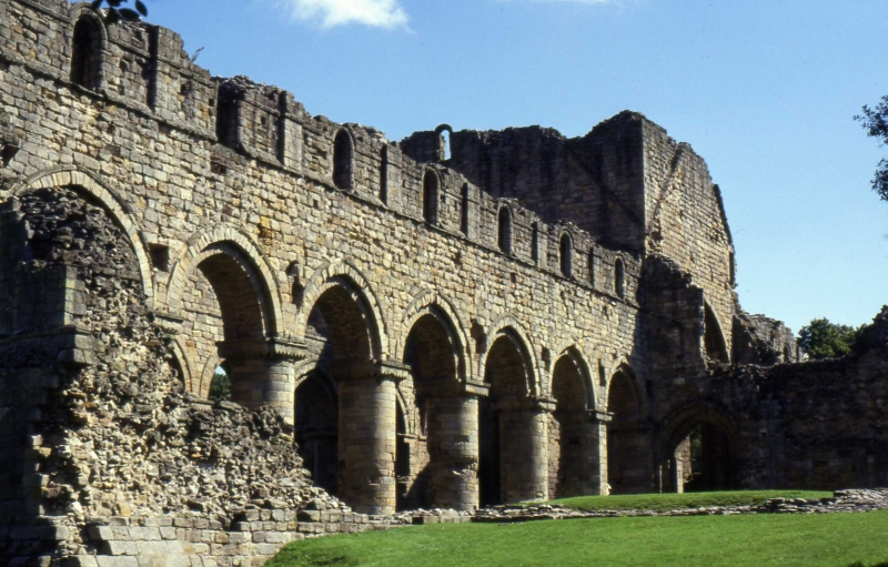
Buildwas Abbey ruins are of sandstone rubble construction with ashlar
dressings, and are Listed Grade I. They show an unusual unity of architectural
style which results from their relatively short period of construction and
an exceptional absence of subsequent alteration. The church and much of the
claustral range were completed by the end of the 12th century, and the
infirmary and abbot's lodging in the 1220s. The only major developments to the
abbey were the construction of the large chapel to the south of the church,
and the addition of a parlour wing to the abbot's house, both in the 14th
century. The aisled church measures c.54m east-west, and consists of a
seven-bay nave, a square ended presbytery of two bays, and a crossing. The low
central tower retains the weather course of the timber roofs of the nave and
transepts. The presbytery and four transept chapels were originally vaulted.
The only structural alterations to the church were at the east end, where the
three tall, round-headed windows replaced smaller ones, probably before 1200.
The three sedilia in the south wall are also 13th century additions, and sit
within arches decorated with dog-tooth ornament. The southern jamb of the
aumbry to the east of these is all that survived the insertion of a tall
narrow window into the south wall. The north and south transepts each have two
square chapels on their east side, and a door leads from the south transept to
the monks' cemetery. The west end of the nave was divided from the quire by a
stone screen or pulpitum, the foundations of which survive. The pointed
arches of the nave arcades rest on ashlar faced piers with scalloped
decoration, some with claw ornaments on their bases. All but the westernmost
were originally closed by low walls, and both arcades survive to the top of
the round-arched clerestory windows. The outer walls of the aisles can be
traced as foundations, and the north aisle had two doors leading to the
cloister. Because of the fall in ground level there was no west doorway to the
church, and the west wall retains two round-headed windows and the sills of
those above. The large 14th century chapel constructed against the wall of the
south aisle was entered by a separate porch at its west end. Its foundations
survive, and within it are a number of graves, some earlier than the chapel
itself.
The basement of the west claustral range and the foundations of the north
range survive, at a lower level than the east and south, but no details
remain of the cloister arcade. The dorter was on the first floor of the east
range, with night stairs from the north transept. Below it are the vaulted
sacristy, and chapter house. The latter is below the level of the cloister,
and is divided by four piers into nine compartments of ribbed vaulting. To the
north is the parlour, also vaulted, with access to the undercroft. The east
range was extended in the 13th century to form the west range of the infirmary
court, which has a five-arched arcade to the north. The west end of this
arcade has been incorporated into the north wall of a post-medieval stable
with a dovecote. The arcade itself is included in the scheduling, but the
stable is in use and the rest of its structure is excluded. Much of the
abbot's house also dates to the 13th century, and includes the substantial
remains of a first-floor hall which retains two pointed windows and two round-
arched doorways with early 13th century ornamentation. The 14th century
parlour wing has an arch-braced collar-beam roof.
The area south and south east of the house was been landscaped to create
formal gardens, probably in the 16th or 17th century. These gardens take the
form of a series of separate terraces into the slope to the south of the
abbot's house. Each terrace is surrounded by a raised walkway from which the
formal layout of the garden on the terrace below could be inspected. Fragments
of standing walls and buried foundations around the gardens probably represent
the original boundary of the post-medieval garden belonging to the Grey family
house. The area to the north of the house, now a car park, was originally a
semicircular terraced garden of the same date and type surrounded by a stone
wall overlooking the river.
The abbey precinct was bounded to the north by the river, and to the west by a
tributary stream. A substantial wall marked its southern boundary, and a 34m
stretch of this survives up to 0.9m high and 0.7m wide in the south west part
of the precinct. East of this the wall has been robbed of stone, leaving a
shallow trench which extends for c.35m, with traces of rubble remaining in
some places. However, the wall would probably have continued eastwards to the
Buildwas road.
Within the precinct, immediately north west of the church and cloister, are a
series of well defined earthworks and hollows, the remains of the fishponds
which would have provided an important component of the monastic diet. The
complex includes a large L-shaped pond to the north west of the west claustral
range, with maximum dimensions of 46m north to south by 42m east to west, and
up to 2m deep. Lying parallel to this and 10m to the west is a linear hollow,
44m north to south by 12m transversely, and up to 1.6m deep. At the southern
end of this pond the buried remains of a sluice can be seen as clear mounds to
either side of a narrow channel. This channel leads south into a second rather
less clearly defined linear hollow on the same alignment as that to the north.
The extent of this feature is not visible on the surface, but the remains of a
leat leading from its southern end can be traced as a shallow ditch overlain
by the railway embankment.
To the west of this fishpond complex a distinct scarp 1.5m high marks the
edge of a flat area now cut by the modern stream channel. Surface sediments
suggest that at sometime this area may have held standing water, possibly
functioning as a mere. To the north west of the fishponds is a sub-rectangular
hollow, c.50m long by 14m wide, and up to 1.5m deep. Although heavily
overgrown and divorced from the main system, this feature appears to be
another pond. North of this, on the margin of the river, are the remains of a
raised mound roughly oval in plan and measuring c.60m east-west by 15m
transversely. This is separated from the bank by a channel or bylet, 7m wide,
which would be subject to flood and which runs parallel to the main river
course. This is probably the much eroded remains of a fish weir, which was
recorded as being on this bank of the river at Buildwas Abbey in 1575.
To the west of the stream which forms the western boundary of the abbey
precinct, and covering an area of c.6ha, are the remains of a system of water
meadows. These comprise a number of rectangular fields, each of which is
bounded by shallow channels averaging 2m wide. Water would have been fed into
the channels from a source to the south, and controlled by sluices to allow
selective irrigation. Ample spring pasture for over-wintered beasts would have
been assured through the maintenance of these meadows. The surplus water would
have fed from the channels into a central drain which runs along the south
edge of the meadows, before turning north to discharge into a substantial
canal. This is orientated roughly east-west, and cuts across the neck of the
river meander forming the north edge of the meadows. This well defined channel
is c.250m long by 14m wide and 2m deep, and is flanked on both sides by levee
banks 8m wide and 0.5m high. At the west end of the channel the southern bank
curves south to merge into the river bank, while the northern bank wraps
around the end of the channel to join onto the south bank, effectively sealing
the channel's end. At the east end the channel branches into two, the northern
and smaller of the two branches probably acting as an outflow, curving north
east to discharge into the river. The southerly channel curves south east and
fades after c.80m on the edge of the possible mere west of the main fishpond
complex. A causeway 20m east of the fork probably represents the site of a
controlled sluice. On the far side of the stream the line of the channel
continues as a slight hollow, which joins the main leat of the fishpond
complex. North of this canal is a pair of rather less distinct ditches, the
northerly of which runs parallel to the river bank and about 15m south of it,
while the southerly runs roughly parallel to the main canal. These ditches
join almost parallel to the main canal. This major water control system was
probably related to flood control and may also have formed part of the fish
weir which survives to the east.
In the south east corner of the water meadow complex are the remains of a
millpond, fed by a contour leat which survives as a clear channel running
south west-north east for c.260m, emerging from the railway embankment at the
south west corner of the field. At its eastern end the leat turns SSE and runs
for c.30m through a brick-lined conduit from which it enters the millpond
immediately north of the embankment. The pond is roughly 12m north-south by 9m
east-west, and up to 2m deep. Its stone lining survives as rubble and sections
of wall, and the mill itself would have occupied the ground to the north. A
rise in ground level to either side of a break in the leat, just west of the
angle in the leat, indicates the site of a sluice, which will survive as a
buried feature. This sluice would have controlled the water supply to the
mill, and an overflow leat can be seen as a shallow channel running from it
towards the river. The millpond drained south through a leat which runs partly
through a brick-lined conduit under the railway embankment, from which it
reappears c.15m west of the north-south stream. South of this it survives as a
distinct channel roughly 1.5m wide, passing under the farm track then
continuing along the line of a field boundary hedge, where its west side is
marked by a steep scarp slope roughly 2m high. At its southern end is the site
of another mill, which would have been operated by the fast-flowing water of
the stream at the point where it is joined by a tributary from the south. The
exact relationship of the leat and stream, and the remains of the mill itself,
have been obscured by the development of the track and driveway to Mill Farm,
but a broad by-pass leat survives to the east of the site, curving round the
bend in the stream as it emerges from under the track.
South of the railway embankment to the east of the stream, the southern extent
of the leat leading to the main fishpond complex within the monastic precinct
can be traced as a shallow ditch which becomes more distinct further south
where it winds through a dog-leg bend. It ends at the north east corner of a
rectangular pond, which measures 52m north-south by 24m east-west, and is up
to 1.4m deep. This pond appears to have been supplied from the south, and
probably discharged through the leat to the north, running a mill which was
sited at the bend. Masonary is visible on both sides of the channel at this
point, and the foundations of an east-west wall to the east of the leat are
probably the remains of the mill building.
West and south of the pond, on slightly raised ground, are a series of
circular embanked enclosures, comprising low regular banks c.1m wide and
c.0.4m high, enclosing parcels of land with an average diameter of 10m. None
of the banks show any evidence for an entrance break, and they are probably
the remains of charcoal burying hearths. Blackened earth with a high charcoal
content which has been observed in the vicinity supports this interpretation.
The abbey had a small iron forge on its Buildwas demesnes at some stage in its
history, and the charcoal may have been used in the smelting process.
Alternatively these hearths may represent an early post-monastic enterprise
and may be related to the development of the iron industry in the Severn
Gorge in the 16th and 17th centuries.
All fences and gates around and across the monument, benches and playground
equipment, the bowls pavilion in the garden and all garden furniture, the
custodian's hut and sales kiosk, all information boards, Abbey House and the
stable block to the west, the medieval arcade which forms the north wall of
the stable building, the modern environmental resource centre, and all
modern surfaces, are excluded from the scheduling, although the ground beneath
all these features is included.
MAP EXTRACT
The site of the monument is shown on the attached map extract.
Source: Historic England
Monasticism was an important aspect of both religious and secular life in
medieval England. Settlements, including monasteries, were built to house
communities of monks, canons (priests) and sometimes lay brothers who lived a
life of religious observance governed by systematic rule. It is estimated from
documentary evidence that over 700 monasteries were founded in England. These
belonged to a wide variety of different religious orders, each with its own
philosophy, and they varied in size from major communities with several
hundred members to tiny establishments with a handful of brethren. As a
result, monasteries vary considerably in their appearance and layout, although
all possess the basic elements of church, living accommodation and work
buildings. Monasteries were inextricably woven into the fabric of medieval
society. They were centres of worship, learning and charity, but also of
immense wealth and political influence and some orders held large estates.
They were established in all parts of England, some in towns and others in the
remotest of areas. Many monasteries acted as the foci of wide networks
including parish churches, almshouses, hospitals, farming estates and tenant
villages.
The Grandmontine order originated in France around AD 1078 when Stephen of
Thiers set up a simple cell in the forest of Muret, outside Limoges. He and
his followers lived an austere existence, and preferred to be known as hermits
rather than monks. In 1124, after Stephen's death, the brethren moved to
Grandmont in Normandy, established their mother house and codified Stephen's
writings. By the middle of the 12th century the popularity of `Stephen's
Rule', and the rapidly increasing number of cells, led to the creation of a
formal order. In the early 13th century, grants of land and rights by powerful
local lords had established three cells in England: at Craswall in
Herefordshire, Alberbury in Shropshire, and Eskdale in Yorkshire. In 1317
Grandmont was raised to the status of an abbey and the three English houses
became priories, though still subject to Grandmont.
At the start of the Hundred Years War with France, most English houses
belonging to French orders (so-called alien priories) were supressed, but the
three Grandmontine houses escaped on account of their poverty. When war was
renewed under Richard II, however, all three were seized by the crown and not
released. The limited excavation that has taken place on Grandmontine sites
has revealed an austerity and changelessness in design which demonstrates the
diversity in form and scale exhibited by monastic sites generally.
Grandmontine monasteries are thus a rare type of a major aspect of English
medieval life. All examples with significant archaeological remains are
considered to be nationally important.
Buildwas Abbey is a fine example of a Savignac monastery which is unusual in
retaining much of its original fabric intact, and in being substantially
unaltered since its early 12th century foundation. This good survival
extends to the extensive fishponds and water management system, which provided
the dietary and economic mainstay of the monastic community.
The standing remains of the abbey retain details of their method of
construction, including the building and decorative techniques employed. The
full extent of the claustral ranges can be established from buried
foundations, and evidence for structures such as gates will survive as buried
remains along the circuit of precinct boundary. Evidence for the construction
of ancillary buildings to the west of the abbey and south and west of the
abbot's house will remain in the form of post holes and buried foundations,
and floor levels within the claustral and ancillary buildings will preserve
environmental and artefactual evidence for the activities which took place
there. All this information will enhance our understanding of the
relationships of the monastic buildings and their various dates and functions.
The subsistence and broader economic setting of this monastic community can be
understood in part from the earthwork remains of the fishponds, leats,
water-meadows and weir, which will retain information relating to their method
of construction and operation, including dams and sluices. Waterlogged
deposits in and around the fish weir will further increase our knowledge of
the operation of this type of device. Evidence for the scale and operation of
the numerous mills will survive as buried features, and the complexity of the
water management systems and the number of major mill sites here point to
industrial working on a large scale. The proximity of the charcoal working
hearths further enhances the impression of this as a centre of industrial
activity, and illustrates the importance, from an early date, of an area which
was to become the centre of the Industrial Revolution. The hearths
themselves will retain evidence for their method of construction and length of
use.
Buildwas Abbey was founded in an area of political instability, and
documentary evidence attests its role during the upheavals of Welsh incursions
and within Ireland. It is thus an important element of the wider picture of
medieval political and social organisation in Shropshire, and also provides an
insight into the varied character of medieval monasticism in England. The
abbey is in the care of the Secretary of State and is open to the public.
Source: Historic England
Books and journals
The Victoria History of the County of Shropshire, (1930), 53
English Heritage, , Buildwas Abbey, (1985)
Turner, J M W, Buildwas Abbey, Shropshire, (1797)
Pannett, DJ, 'BAR British Series 182(ii)' in Fish Weirs of the River Severn with Partic Reference to Shrops, , Vol. 182(ii), (1988), 385
Other
Appears in Victoria County History Shropshire, Vol. 2, Victoria County History, Buildwas Abbey,
Barrett, Glyn, (1995)
Overy, C G D, MPP MCD - Water meadows, (1990)
photos, Victoria County History, History of Shropshire, Vol. 2,
Source: Historic England
Other nearby scheduled monuments