Approximate Location Map
Large Map »
This site is entirely user-supported. See how you can help.
Latitude: 52.5969 / 52°35'49"N
Longitude: -2.5551 / 2°33'18"W
OS Eastings: 362495.396899
OS Northings: 300050.41255
OS Grid: SJ624000
Mapcode National: GBR BS.9HN7
Mapcode Global: WH9DF.QZGH
Entry Name: Wenlock Priory
Scheduled Date: 8 February 1915
Last Amended: 22 January 2015
Source: Historic England
Source ID: 1004779
English Heritage Legacy ID: SA 9
County: Shropshire
Civil Parish: Much Wenlock
Built-Up Area: Much Wenlock
Traditional County: Shropshire
Lieutenancy Area (Ceremonial County): Shropshire
Church of England Parish: Much Wenlock with Bourton
Church of England Diocese: Hereford
Wenlock Priory; the standing structural, earthwork and buried remains of a Cluniac Priory built between 1140 and 1180 and largely rebuilt from 1200 to 1240. Included are earlier, buried Roman remains adapted for use as a pre-Cluniac Saxon monastery.
Source: Historic England
PRINCIPAL ELEMENTS
Wenlock Priory; the standing structural, earthwork and buried remains of a Cluniac Priory built between 1140 and 1180 and largely rebuilt from 1200 to 1240. Included are earlier, buried Roman remains adapted for use as a pre-Cluniac Saxon monastery.
DESCRIPTION
The earliest upstanding remains on the site include the Chapter House and parts of the Lavatorium and Dormitory range. The Infirmary Hall and Reredorter also date from this period, but are in domestic use and listed at Grade I and excluded from the scheduling. The Chamber Block to the west of the Reredorter is also in domestic use and also listed at Grade I and excluded from the scheduling.
The CHAPTER HOUSE measures approximately 15m by 8m. Walls to the north, south and west sides rise to almost their full height, including the springing of the ribs, but the vault of three bays does not survive. The front to the cloister has three arches; a central doorway flanked by windows. Each had nook shafts which have now gone, but the arches have rich moulding of chevron and scallops dotted with pellets. Inside, the flank walls have a plain dado against which the monks sat, above which are three tiers of intersecting arches, carved in relief and supported by miniature columns.
Immediately to the south of the chapter house is the DORMITORY range. Survival is fragmentary above ground and confined to the blank west gable end which stands to nearly full height.
The LAVATORIUM is set in the south-western corner of the cloister garth, close to the door to the refectory. The octagonal, external walls do not survive above ground level, but the central cistern and bowl of Wenlock marble were excavated in 1878 from beneath a grassy mound and found to be of two dates. The circular cistern is of c.1180-90 with a fluted interior and foliage to its outer face. This feeds a trough, where the monks washed. The trough is of c.1220, but included relief panels of the earlier date, including depictions of Christ and the Apostles. The original panels have now been removed for safe storage and replicas inserted.
Later upstanding remains on the site include parts of the C13 church and refectory and the polygonal sacristy of the late C14 and the Lady chapel of the C15.
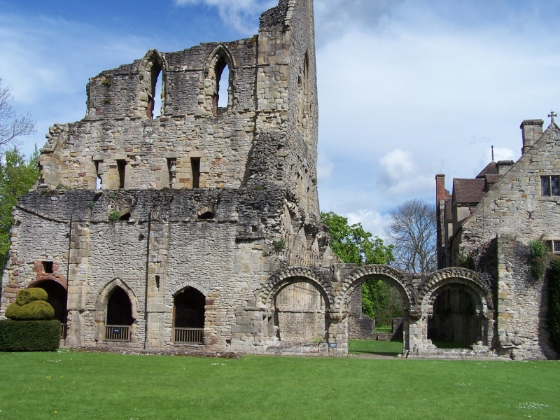
The CHURCH has a nave of eight bays and a choir of seven bays. The transepts each have three bays, with eastern side chapels. It seems likely that a central tower was built or planned, judging from the size of the central piers. The lengthy choir probably also contained the shrine of St Milburga at its eastern end.
Archaeological excavation has established that the Norman church had a similar width to the nave and aisles, although the overall length was much less. The plan of the C13 building had certain peculiarities, including a laver to the west wall of the south transept. On the opposite side of this wall was a three bay library, which faced onto the east side of the cloister. It had a central arched doorway flanked by windows, but the two lateral window openings were widened to form the present wide doorways after the Dissolution when the buildings were used as a farm.
The majority of the walling and the piers of the church are now less than 2 metres in height, but the south-western corner of the nave, the south transept and the west wall of the north transept survive to almost their full height. They show a church of relatively uniform appearance throughout. The pier arcades had keeled shafts to the columns and bell caps. Above each arch of the aisle arcades were two tall triforium openings with a wall passage, and there was a clerestory to the top, also with a wall passage, and with a single lancet to each bay in the transepts which was widened to two-light openings with a traceried head in the nave. The church had a stone vault with ribs which sprang from clusters of shafts that rose from attenuated corbels at the arcade level.
The SOUTH-WEST CORNER of the nave has an internal elevation with three squat bays to the aisles. This is accounted for by an upper chapel at the level of the upper arcade and triforium which connected to the Prior’s lodging above the west side of the cloister. This Chapel of St Michael faces outwards to the south with two windows of two lights and a similar western window. Its vaulted interior has wall shafts which rise from die-out corbels in imitation of the church interior. The western, external, walling at this corner incorporates the south side of the main west door with a deep recess and above this is part of a window surround, flanked by panels of blind tracery.
The SOUTH TRANSEPT retains the arcade of three openings to eastern-facing chapels and the three graduated arches of the laver to its west wall. Its south wall rises to full height, including the gable.
The NORTH TRANSEPT has its west wall to nearly full height. On the west side of this is a shallow crypt.
The later SACRISTY and LADY CHAPEL survive as low walls above ground, but their foundations will survive as buried features.
The CHAMBER BLOCK west of the Reredorter was originally attached to an aisled hall which joined to its western flank but is now demolished, although evidence of its form is likely to remain as a buried feature.
The other sizeable building dating from the C15 is the PRIOR’S LODGING. Tree ring analysis dates the roof to c.1425 and it may have also been refaced to both the east and west fronts in the late C15. As with the former Infirmary Hall, Reredorter and Chamber Block, the building is listed at Grade I and excluded from the scheduling.
Beyond the core of the site were various satellite features associated with the life of the monastery. To the south-east of the priory is the site of the ‘Great pool’ which was associated with a mill. The site of the mill has been established, and the raised earth dam which provided the head of water to work the mill mechanism is well preserved at its western end with stones that formed a road surface, still visible. The western end of the dam bank, measuring approximately 170 metres, together with the mill site are included in the scheduling, but the eastern extension beyond the mill is less well preserved and it is not included. To the west of the priory church are the remains of a gate range. This has a tower at the western end, which is preserved as a listed building (Priory Tower, listed Grade II) but which lies outside the area of the scheduling. Approximately 10 metres to the east of this there was formerly a further part of the gatehouse range. This was recorded as inhabited in 1662, but collapsed in 1845 and no part of it is now visible above ground, and although evidence of its form is likely to remain as buried features, these remains lie outside the area of the present scheduling. The area to the north of the church will form a burial ground associated with the priory and the area to the south-west of the priory buildings was the site of farm buildings in the C19 and it is likely that this was also the site of earlier agricultural buildings. Boundary and retaining walls in this area contain old stonework, which appear to have been, in part, related to the activities of the priory.
EXCLUSIONS: Priory House (also known as Wenlock Abbey and which incorporates the former Prior’s Lodging and Infirmary Hall, Reredorter and Chamber Block) is listed at Grade I and is excluded from the scheduling although the ground beneath is included. In addition the site now has a number of later features which do not form part of the scheduling. These include all modern surfaces, fence posts, railings, flood lights and the concrete bases on which they stand, interpretation signage, litter bins and park furniture. The garden wall to the north east of Priory House is also excluded, as is the octagonal garden pavilion attached to it. The stone wall bordering the south-west side of the drive is excluded, as is the ticket office and shop building at the north-east corner of the site. The ground beneath all these features is, however, included.
Source: Historic England
Wenlock Priory, a Saxon foundation, and re-formed as a Cluniac priory which continued until 1540, is scheduled for the following principal reasons:
* Archaeological potential: it has been shown there are well-stratified archaeological deposits from the site's history over almost two millennia;
* Historical: the site is well documented, notably its 860-year monastic history;
* Architectural: considerable portions of the priory remain standing; especially notable is the distinctive and high-quality Cluniac carving;
* Context and group value: with the upstanding Grade I-listed Wenlock Abbey (the former prior's lodgings), the other listed monastic ruins and buildings, and the planned monastic town of Much Wenlock.
Source: Historic England
Books and journals
Victoria County History Shropshire (2), (1973), 45-46
Julie Pinnell, , Wenlock Abbey, (2013)
Pevsner N, , Newman, J, The Buildings of England: Shropshire, (2006), 418-426
'' in Country Life, , Vol. 128, (15 December 1960), 1492
'' in Country Life, (1 December 1960), 1282
'' in Country Life, , Vol. 128, (8 December 1960)
'Archaeologia' in Archaeologia, , Vol. LXXII, (), 109-131
Source: Historic England
Other nearby scheduled monuments