Approximate Location Map
Large Map »
This site is entirely user-supported. See how you can help.
Latitude: 54.501 / 54°30'3"N
Longitude: -1.0051 / 1°0'18"W
OS Eastings: 464528.299056
OS Northings: 512196.74217
OS Grid: NZ645121
Mapcode National: GBR PJFD.69
Mapcode Global: WHF8M.J4L9
Entry Name: Cross ridge dyke north of North Ings Slack and west of Hob on the Hill tumulus
Scheduled Date: 14 March 1997
Source: Historic England
Source ID: 1015266
English Heritage Legacy ID: 28290
County: North Yorkshire
Civil Parish: Commondale
Traditional County: Yorkshire
Lieutenancy Area (Ceremonial County): North Yorkshire
Church of England Parish: Danby with Castleton and Commondale
Church of England Diocese: York
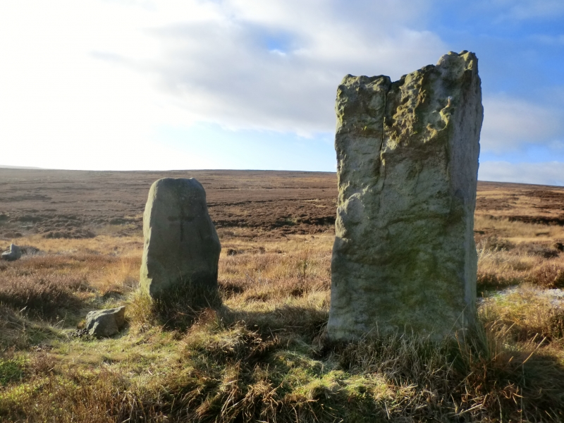
The monument includes a cross ridge dyke incorporating an earlier stone
alignment extending for 510m southward from the crest by the Hob on the Hill
round barrow to the edge of North Ings Slack.
The dyke is a discontinuous earthwork 410m in length built around an alignment
of small exposed standing stones. The earthwork comprises a bank up to 5m wide
and 0.75m high with a ditch to the west up to 2.5m wide and 0.4m deep. In some
places there is a marked counterscarp bank to the west of the ditch up to 1.5m
wide and 0.4m high.
The stone alignment includes a series of stones, placed individually and in
close-set groups. The stone alignment extends beyond the earthwork by 100m to
terminate at the bank North Ings Slack.
Excavations in 1991 revealed that the stone alignment originally included more
stones than now survive and that the aligment existed for some time before the
ditch was dug and the stones were partly encapsulated by the bank.
The monument lies in an area rich in prehistoric remains including field
systems and burial mounds.
MAP EXTRACT
The site of the monument is shown on the attached map extract.
It includes a 2 metre boundary around the archaeological features,
considered to be essential for the monument's support and preservation.
Source: Historic England
Cross dykes are substantial linear earthworks typically between 0.2km and 1km
long and comprising one or more ditches arranged beside and parallel to one or
more banks. They generally occur in upland situations, running across ridges
and spurs. They are recognised as earthworks or as cropmarks on aerial
photographs, or as combinations of both. The evidence of excavation and
analogy with associated monuments demonstrates that their construction spans
the millennium from the Middle Bronze Age, although they may have been re-used
later. Current information favours the view that they were used as territorial
boundary markers, probably demarcating land allotment within communities,
although they may also have been used as trackways, cattle droveways or
defensive earthworks. Cross dykes are one of the few monument types which
illustrate how land was divided up in the prehistoric period. They are of
considerable importance for any analysis of settlement and land use in the
Bronze Age. Very few have survived to the present day and hence all well-
preserved examples are considered to be of national importance.
The cross ridge dyke north of North Ings Slack survives well and important
archaeological remains will be preserved within it. It it demonstrates a
sequence of construction from a stone alignment to a more substantial
earthwork. Similar monuments survive elswhere in the region. The monument lies
in close proximity to major prehistoric burial sites and it is thought that
the substantial and impressive dyke may also have had a ritual function.
Source: Historic England
Books and journals
Vyner, B, 'Antiquity' in The Territory Of Ritual: Cross-Ridge Boundaries in Cleveland, (1994), 27-38
Vyner, B, 'Antiquity' in The Territory Of Ritual: Cross-Ridge Boundaries in Cleveland, (1994), 27-38
Source: Historic England
Other nearby scheduled monuments