Approximate Location Map
Large Map »
This site is entirely user-supported. See how you can help.
Latitude: 50.7958 / 50°47'44"N
Longitude: -3.9426 / 3°56'33"W
OS Eastings: 263190.22013
OS Northings: 101377.643079
OS Grid: SS631013
Mapcode National: GBR KW.Z525
Mapcode Global: FRA 26MZ.PW5
Entry Name: Wayside cross at crossroads 120m NNW of St Andrew's Church
Scheduled Date: 31 May 1974
Last Amended: 20 December 1995
Source: Historic England
Source ID: 1013737
English Heritage Legacy ID: 27311
County: Devon
Civil Parish: Sampford Courtenay
Traditional County: Devon
Lieutenancy Area (Ceremonial County): Devon
Church of England Parish: Sampford Courtenay St Andrew
Church of England Diocese: Exeter
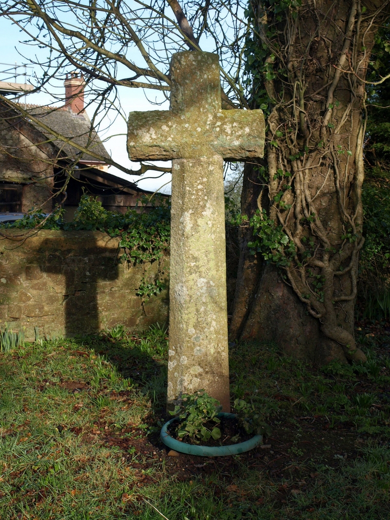
This monument includes a wayside cross in Sampford Courtenay standing at a
crossroads between Bulland Lane, Weirford Lane and an unclassified road
through the village. The shaft of the cross is ancient; the head and arms are
modern. The cross measures 0.3m at the base and tapers to 0.22m. The ancient
section of shaft attains a height of 1.36m. The restored head is directly
above the shaft and measures 0.56m wide at the arms, is 0.22m in thickness and
is 0.7m high. The shaft and head are octagonal in section although the back
of the shaft has been trimmed. The cross head is of a plain Latin shape and
probably dates to the 15th century. The cross is one of a group lying within
the vicinity of Sampford Courtenay village.
In 1919 the shaft was found during alterations to an old farmhouse,
approximately opposite to the present site. It was being used as a supporter
for a fireplace beam. The cross was re-erected and restored in its original
site in 1927 after the demolition of the house. The cross is Listed Grade II.
The metalled road surface is excluded from the scheduling where this falls
within the cross's protective margin, although the ground beneath is included.
MAP EXTRACT
The site of the monument is shown on the attached map extract.
It includes a 2 metre boundary around the archaeological features,
considered to be essential for the monument's support and preservation.
Source: Historic England
Wayside crosses are one of several types of Christian cross erected during the
medieval period, mostly from the 9th to 15th centuries AD. In addition to
serving the function of reiterating and reinforcing the Christian faith
amongst those who passed the cross and of reassuring the traveller, wayside
crosses often fulfilled a role as waymarkers, especially in difficult and
otherwise unmarked terrain. The crosses might be on regularly used routes
linking ordinary settlements or on routes having a more specifically religious
function, including those providing access to religious sites for parishioners
and funeral processions, or marking long-distance routes frequented on
pilgrimages.
Over 350 wayside crosses are known nationally, concentrated in south west
England throughout Cornwall and on Dartmoor where they form the commonest type
of stone cross. A small group also occurs on the North York Moors. Relatively
few examples have been recorded elsewhere and these are generally confined to
remote moorland locations.
Outside Cornwall almost all wayside crosses take the form of a `Latin' cross,
in which the cross-head itself is shaped within the projecting arms of an
unenclosed cross. In Cornwall wayside crosses vary considerably in form and
decoration. The commonest type includes a round, or `wheel', head on the faces
of which various forms of cross or related designs were carved in relief or
incised, the spaces between the cross arms possibly pierced. The design was
sometimes supplemented with a relief figure of Christ and the shaft might bear
decorative panels and motifs. Less common forms in Cornwall include the
`Latin' cross and, much rarer, the simple slab with a low relief cross on both
faces. Rare examples of wheel-head and slab-form crosses also occur within the
North York Moors group. Most wayside crosses have either a simple socketed
base or show no evidence for a separate base at all.
Wayside crosses contribute significantly to our understanding of medieval
religious customs and sculptural traditions and to our knowledge of medieval
routeways and settlement patterns. All wayside crosses which survive as earth-
fast monuments, except those which are extremely damaged and removed from
their original locations, are considered worthy of protection.
The wayside cross at a crossroads 120m NNW of St Andrew's Church survives well
and is thought likely to be in its original position. This cross is one of a
group of five in the village, an unusual concentration in this area.
Source: Historic England
Other
Clayton,C, (1994)
Devon County Sites and Monuments Register, SS60SW-012, (1982)
MPP fieldwork by H.Gerrard, (1994)
Source: Historic England
Other nearby scheduled monuments