Approximate Location Map
Large Map »
This site is entirely user-supported. See how you can help.
Latitude: 54.3384 / 54°20'18"N
Longitude: -0.776 / 0°46'33"W
OS Eastings: 479675.61728
OS Northings: 494342.359125
OS Grid: SE796943
Mapcode National: GBR RL08.SK
Mapcode Global: WHF9J.16QX
Entry Name: Mauley Cross in Cropton Forest 580m north of Hill Top Farm
Scheduled Date: 24 July 1964
Last Amended: 12 December 1994
Source: Historic England
Source ID: 1011745
English Heritage Legacy ID: 25684
County: North Yorkshire
Civil Parish: Stape
Traditional County: Yorkshire
Lieutenancy Area (Ceremonial County): North Yorkshire
Church of England Parish: Newton St John
Church of England Diocese: York
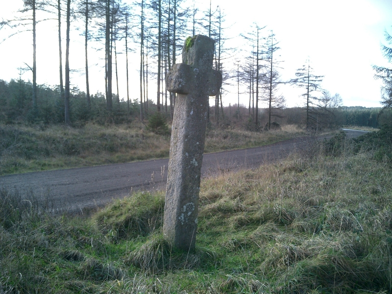
The monument comprises a wayside cross called Mauley Cross. It stands 80m to
the east of the line of the Roman road from Cawthorne Roman camps north to New
Wath Farm. This route was a trackway in the medieval period.
The cross is carved from a single slab of fine gritstone. It stands 3m north
of the forest track called the Brown Howe Road, on a raised bank 1.5m above
the road surface. It is earthfast without a socket.
The cross stands 2.12m high, facing north-south. The shaft is 0.27m by 0.23m
wide. The head is carved out at a point 1.57m from the ground. The arms of
the cross are 0.25m wide and project 0.13m from the shaft. There is an OS
benchmark on the north face; otherwise there is no trace of ornament or
decoration. The cross is worn and weathered so that the arms appear to be
rounded.
The cross dates from the medieval period and is a wayside religious symbol for
the ancient trackway which continues the use of the Roman road. It takes its
name from the landowning De Mauley family of Mulgrave.
MAP EXTRACT
The site of the monument is shown on the attached map extract.
It includes a 2 metre boundary around the archaeological features,
considered to be essential for the monument's support and preservation.
Source: Historic England
Wayside crosses are one of several types of Christian cross erected during the
medieval period, mostly from the 9th to 15th centuries AD. In addition to
serving the function of reiterating and reinforcing the Christian faith
amongst those who passed the cross and of reassuring the traveller, wayside
crosses often fulfilled a role as waymarkers, especially in difficult and
otherwise unmarked terrain. The crosses might be on regularly used routes
linking ordinary settlements or on routes having a more specifically religious
function, including those providing access to religious sites for parishioners
and funeral processions, or marking long-distance routes frequented on
pilgrimages.
Over 350 wayside crosses are known nationally, concentrated in south west
England throughout Cornwall and on Dartmoor where they form the commonest type
of stone cross. A small group also occurs on the North York Moors. Relatively
few examples have been recorded elsewhere and these are generally confined to
remote moorland locations.
Outside Cornwall almost all wayside crosses take the form of a `Latin' cross,
in which the cross-head itself is shaped within the projecting arms of an
unenclosed cross. In Cornwall wayside crosses vary considerably in form and
decoration. The commonest type includes a round, or `wheel', head on the faces
of which various forms of cross or related designs were carved in relief or
incised, the spaces between the cross arms possibly pierced. The design was
sometimes supplemented with a relief figure of Christ and the shaft might bear
decorative panels and motifs. Less common forms in Cornwall include the
`Latin' cross and, much rarer, the simple slab with a low relief cross on both
faces. Rare examples of wheel-head and slab-form crosses also occur within the
North York Moors group. Most wayside crosses have either a simple socketed
base or show no evidence for a separate base at all.
Wayside crosses contribute significantly to our understanding of medieval
religious customs and sculptural traditions and to our knowledge of medieval
routeways and settlement patterns. All wayside crosses which survive as earth-
fast monuments, except those which are extremely damaged and removed from
their original locations, are considered worthy of protection.
The Mauley Cross wayside cross still stands as a reminder of the important
line of communication marked by the Roman road beside it to the west.
The cross is in good condition although weathered and its survival as a single
piece of stone is remarkable.
It also reminds us of the religious organisation of the medieval landscape and
the piety expected of the travellers of that period.
Source: Historic England
Books and journals
Graham, L, The Crosses of the North Yorkshire Moors, (1993), 40
Hayes, R H, Old Roads and Pannierways in North East Yorkshire, (1988), 27
Source: Historic England
Other nearby scheduled monuments