Approximate Location Map
Large Map »
This site is entirely user-supported. See how you can help.
Latitude: 50.0893 / 50°5'21"N
Longitude: -5.5449 / 5°32'41"W
OS Eastings: 146536.139753
OS Northings: 27036.515569
OS Grid: SW465270
Mapcode National: GBR DXPF.WFW
Mapcode Global: VH05P.V00X
Entry Name: Medieval wayside cross at Paul
Scheduled Date: 16 February 1994
Source: Historic England
Source ID: 1010322
English Heritage Legacy ID: 24277
County: Cornwall
Civil Parish: Penzance
Traditional County: Cornwall
Lieutenancy Area (Ceremonial County): Cornwall
Church of England Parish: Paul
Church of England Diocese: Truro
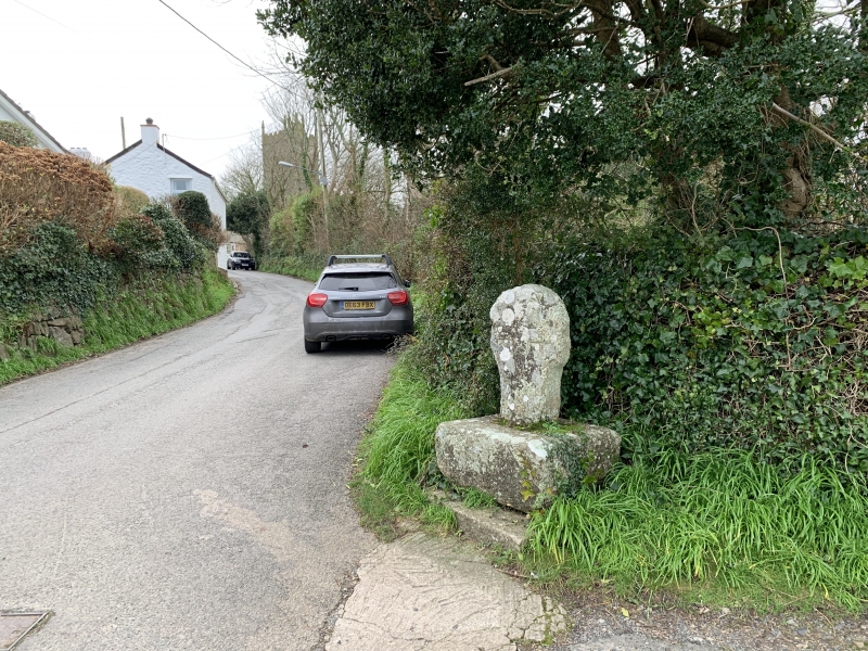
The monument includes a medieval wayside cross and a 2m protective margin
situated at the south-east edge of Paul beside the road to Mousehole on the
southern coast of Penwith in west Cornwall.
The wayside cross at Paul survives with an upright granite shaft and a round
or 'wheel' head set in a square base, measuring 1.35m in overall height. The
head is 0.54m in diameter and 0.19m thick. Each principal face of the head
bears a relief Latin cross measuring 0.73m high and 0.43m across the limbs.
The upper limbs have slightly splayed ends, while the lower limb gradually
tapers as it extends beyond the head down the centre of the shaft. The
rectangular-section shaft measures 0.38m high from the base to the neck and is
0.39m wide and 0.19m thick. The shaft is undecorated apart from the extended
lower limb of the head's relief cross forming a raised midline along most of
the shaft on each main face. The shaft is cemented into the centre of a large
square granite base stone with weathered, dressed faces and measuring 0.84m
long by 0.85m wide and 0.43m high. This base stone is located on two adjoining
granite slabs forming a plinth measuring 1.05m east-west by 1.19m north-south
and projecting up to 0.36m beyond the south face of the base stone. This
wayside cross and its base stone were discovered c.1878 buried in the
hedgebank almost opposite its present location on the road to Mousehole; such
deliberate slighting and burial next to their former locations affected a
number of wayside crosses during the Reformation (c.1540). By 1896, the cross
had been re-erected at its present site, close to its former location and
sharing the same relationship to the roads in the vicinity. It marks a minor
junction at the south-east edge of the village, on the important road linking
the village and its parish church with the harbour at Mousehole, also within
the parish, 0.75km to the south-east. The cross is sited on the junction of
the Mousehole road with an unmetalled track to the present vicarage in the
village.
The surfaces of the metalled road south of the cross and the unmetalled track
to the east, and the fire hydrant marker-post to the west of the cross are
excluded from the scheduling although the ground beneath these features is
included.
MAP EXTRACT
The site of the monument is shown on the attached map extract.
It includes a 2 metre boundary around the archaeological features,
considered to be essential for the monument's support and preservation.
Source: Historic England
Wayside crosses are one of several types of Christian cross erected during the
medieval period, mostly from the 9th to 15th centuries AD. In addition to
serving the function of reiterating and reinforcing the Christian faith
amongst those who passed the cross and of reassuring the traveller, wayside
crosses often fulfilled a role as waymarkers, especially in difficult and
otherwise unmarked terrain. The crosses might be on regularly used routes
linking ordinary settlements or on routes having a more specifically religious
function, including those providing access to religious sites for parishioners
and funeral processions, or marking long-distance routes frequented on
pilgrimages.
Over 350 wayside crosses are known nationally, concentrated in south west
England throughout Cornwall and on Dartmoor where they form the commonest type
of stone cross. A small group also occurs on the North York Moors. Relatively
few examples have been recorded elsewhere and these are generally confined to
remote moorland locations.
Outside Cornwall almost all wayside crosses take the form of a `Latin' cross,
in which the cross-head itself is shaped within the projecting arms of an
unenclosed cross. In Cornwall wayside crosses vary considerably in form and
decoration. The commonest type includes a round, or `wheel', head on the faces
of which various forms of cross or related designs were carved in relief or
incised, the spaces between the cross arms possibly pierced. The design was
sometimes supplemented with a relief figure of Christ and the shaft might bear
decorative panels and motifs. Less common forms in Cornwall include the
`Latin' cross and, much rarer, the simple slab with a low relief cross on both
faces. Rare examples of wheel-head and slab-form crosses also occur within the
North York Moors group. Most wayside crosses have either a simple socketed
base or show no evidence for a separate base at all.
Wayside crosses contribute significantly to our understanding of medieval
religious customs and sculptural traditions and to our knowledge of medieval
routeways and settlement patterns. All wayside crosses which survive as earth-
fast monuments, except those which are extremely damaged and removed from
their original locations, are considered worthy of protection.
The wayside cross at Paul has survived well. It forms a good example of a
wheel-headed wayside cross, bearing a distinctive and unusual style of cross
head motif. Although slightly re-located from its burial site by its former
position, it remains as a marker on the same important route and way to the
church within the parish. As such a marker, this cross demonstrates well the
major function of wayside crosses and shows the longevity of many roads still
in use. The burial of this cross in the hedgebank until the later 19th century
and its subsequent restoration illustrates the changing attitudes to religion
that have prevailed since the Reformation and the impact of those changes on
the landscape.
Source: Historic England
Books and journals
Henderson, C, The Cornish Church Guide, (1928)
Langdon, A G, Old Cornish Crosses, (1896)
Other
Info. told to MPPFW by Mr Andrew Langdon on 19/7/1993, (1993)
Title: 1:25000 Ordnance Survey Map; SW 32/42; Pathfinder Series 1368
Source Date: 1980
Author:
Publisher:
Surveyor:
Source: Historic England
Other nearby scheduled monuments