Approximate Location Map
Large Map »
This site is entirely user-supported. See how you can help.
Latitude: 54.2543 / 54°15'15"N
Longitude: -0.9758 / 0°58'33"W
OS Eastings: 466821.067184
OS Northings: 484772.389726
OS Grid: SE668847
Mapcode National: GBR PMM7.JQ
Mapcode Global: WHF9S.ZBHF
Entry Name: Wayside cross called Stony Cross on the A170 920m south east of Highfield House
Scheduled Date: 10 October 1995
Source: Historic England
Source ID: 1010077
English Heritage Legacy ID: 25656
County: North Yorkshire
Civil Parish: Wombleton
Traditional County: Yorkshire
Lieutenancy Area (Ceremonial County): North Yorkshire
Church of England Parish: Kirkdale St Gregory
Church of England Diocese: York
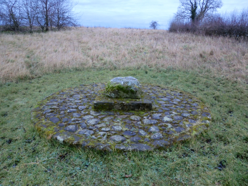
The monument includes a cross-inscribed stone called Stony Cross set up beside
the A170 from Helmsley to Pickering where the road from Wombleton joins it.
The Thurkilsti, one of the four most important medieval roads from south to
north across the North York Moors, crosses the A170 at this point or close to
it as it goes from Sunley Hill towards the Skiplam Road.
The cross consists of a shaped sandstone block set on a modern plinth resting
on a platform of cobbles. The stone is 0.57m square with the top edges rounded
off and a deeply incised cross cut across the top. It seems to be a cushion
capital from a building reused as a waymarker. The modern plinth is 0.94m
square made of pieces of sandstone and the whole is built into a circular
cobbled platform 3m in diameter.
The cross is in its original position and the modern plinth and stone cross
are included in this scheduling together with the ground beneath. The modern
cobbled platform is not included in the scheduling.
MAP EXTRACT
The site of the monument is shown on the attached map extract.
It includes a 2 metre boundary around the archaeological features,
considered to be essential for the monument's support and preservation.
Source: Historic England
Wayside crosses are one of several types of Christian cross erected during the
medieval period, mostly from the 9th to 15th centuries AD. In addition to
serving the function of reiterating and reinforcing the Christian faith
amongst those who passed the cross and of reassuring the traveller, wayside
crosses often fulfilled a role as waymarkers, especially in difficult and
otherwise unmarked terrain. The crosses might be on regularly used routes
linking ordinary settlements or on routes having a more specifically religious
function, including those providing access to religious sites for parishioners
and funeral processions, or marking long-distance routes frequented on
pilgrimages.
Over 350 wayside crosses are known nationally, concentrated in south west
England throughout Cornwall and on Dartmoor where they form the commonest type
of stone cross. A small group also occurs on the North York Moors. Relatively
few examples have been recorded elsewhere and these are generally confined to
remote moorland locations.
Outside Cornwall almost all wayside crosses take the form of a `Latin' cross,
in which the cross-head itself is shaped within the projecting arms of an
unenclosed cross. In Cornwall wayside crosses vary considerably in form and
decoration. The commonest type includes a round, or `wheel', head on the faces
of which various forms of cross or related designs were carved in relief or
incised, the spaces between the cross arms possibly pierced. The design was
sometimes supplemented with a relief figure of Christ and the shaft might bear
decorative panels and motifs. Less common forms in Cornwall include the
`Latin' cross and, much rarer, the simple slab with a low relief cross on both
faces. Rare examples of wheel-head and slab-form crosses also occur within the
North York Moors group. Most wayside crosses have either a simple socketed
base or show no evidence for a separate base at all.
Wayside crosses contribute significantly to our understanding of medieval
religious customs and sculptural traditions and to our knowledge of medieval
routeways and settlement patterns. All wayside crosses which survive as earth-
fast monuments, except those which are extremely damaged and removed from
their original locations, are considered worthy of protection.
The Stony Cross wayside cross survives as a single cushion capital of fine
sandstone with a cross incised on it. It marks the line of the Thurkilsti
medieval road which appears in a Rievaulx charter of AD 1145 granting land
from Walter L'Espec. It gives us insight into the organisation of the medieval
landscape and the implied piety of the medieval Christian traveller.
Source: Historic England
Books and journals
Hayes, R H, Old Roads and Pannierways in North East Yorkshire, (1988), 41
Source: Historic England
Other nearby scheduled monuments