Approximate Location Map
Large Map »
This site is entirely user-supported. See how you can help.
Latitude: 54.3291 / 54°19'44"N
Longitude: -1.0989 / 1°5'55"W
OS Eastings: 458699.451923
OS Northings: 492991.597063
OS Grid: SE586929
Mapcode National: GBR NLRC.WW
Mapcode Global: WHF9C.3G02
Entry Name: Wayside cross 950m east of Spout House Plantation
Scheduled Date: 3 November 1951
Last Amended: 3 November 1994
Source: Historic England
Source ID: 1009370
English Heritage Legacy ID: 25555
County: North Yorkshire
Civil Parish: Bilsdale Midcable
Traditional County: Yorkshire
Lieutenancy Area (Ceremonial County): North Yorkshire
Church of England Parish: Helmsley All Saints
Church of England Diocese: York
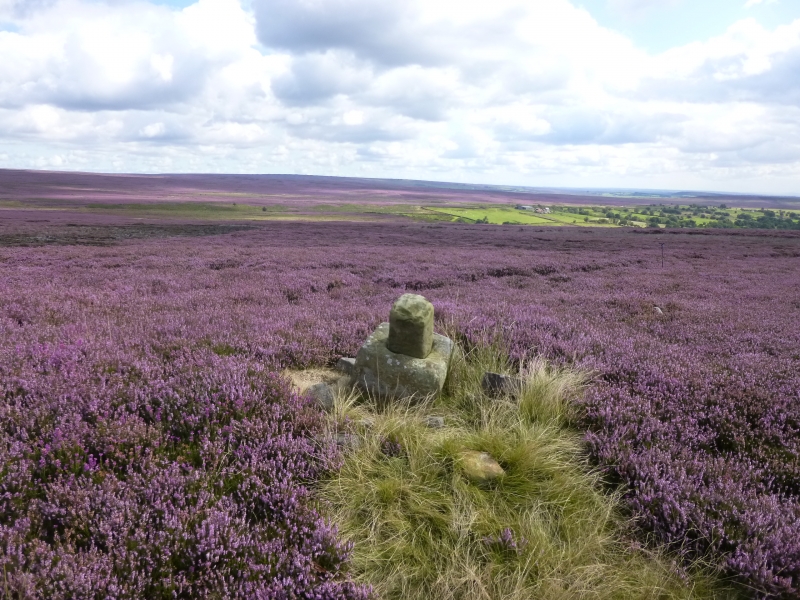
The monument includes a wayside cross on the top of Helmsley Moor.
The cross has a base stone carved from a single block, measuring 0.5m
square and standing 0.4m high. The lower part of the cross shaft still
standing loosely in its socket. The remains of the shaft are 0.45m high and
0.2m by 0.25m in section. The cross known as Roppa Cross North stands as a
marker on the old Helmsley to Stokesley road.
The monument is one of a series of crosses marking routes across the
difficult upland terrain and as such provides significant insights into social
and ritual traditions as well as patterns of communication in the medieval and
post medieval periods.
MAP EXTRACT
The site of the monument is shown on the attached map extract.
It includes a 2 metre boundary around the archaeological features,
considered to be essential for the monument's support and preservation.
Source: Historic England
Wayside crosses are one of several types of Christian cross erected during the
medieval period, mostly from the 9th to 15th centuries AD. In addition to
serving the function of reiterating and reinforcing the Christian faith
amongst those who passed the cross and of reassuring the traveller, wayside
crosses often fulfilled a role as waymarkers, especially in difficult and
otherwise unmarked terrain. The crosses might be on regularly used routes
linking ordinary settlements or on routes having a more specifically religious
function, including those providing access to religious sites for parishioners
and funeral processions, or marking long-distance routes frequented on
pilgrimages.
Over 350 wayside crosses are known nationally, concentrated in south west
England throughout Cornwall and on Dartmoor where they form the commonest type
of stone cross. A small group also occurs on the North York Moors. Relatively
few examples have been recorded elsewhere and these are generally confined to
remote moorland locations.
Outside Cornwall almost all wayside crosses take the form of a `Latin' cross,
in which the cross-head itself is shaped within the projecting arms of an
unenclosed cross. In Cornwall wayside crosses vary considerably in form and
decoration. The commonest type includes a round, or `wheel', head on the faces
of which various forms of cross or related designs were carved in relief or
incised, the spaces between the cross arms possibly pierced. The design was
sometimes supplemented with a relief figure of Christ and the shaft might bear
decorative panels and motifs. Less common forms in Cornwall include the
`Latin' cross and, much rarer, the simple slab with a low relief cross on both
faces. Rare examples of wheel-head and slab-form crosses also occur within the
North York Moors group. Most wayside crosses have either a simple socketed
base or show no evidence for a separate base at all.
Wayside crosses contribute significantly to our understanding of medieval
religious customs and sculptural traditions and to our knowledge of medieval
routeways and settlement patterns. All wayside crosses which survive as earth-
fast monuments, except those which are extremely damaged and removed from
their original locations, are considered worthy of protection.
This wayside cross has an intact crossbase and portion of shaft and is still
in its original position marking an important routeway from Helmsley to
Stokesley. The route played an important role in the medieval period
connecting the monastic houses to the south of the Moors with those to the
north. Together with other crosses on the North York Moors this monument
provides important evidence of the social and ritual traditions and the
complex network of routeways amongst both lay and ecclesiastical communities
in the medieval period.
Source: Historic England
Books and journals
Graham, L, M, , 'The Crosses of the North York Moors' in The Crosses of the North York Moors, (1993), p17
Other
Pacitto A, FMW REPORT, (1991)
Source: Historic England
Other nearby scheduled monuments