Approximate Location Map
Large Map »
This site is entirely user-supported. See how you can help.
Latitude: 53.3323 / 53°19'56"N
Longitude: -2.0081 / 2°0'29"W
OS Eastings: 399556.28
OS Northings: 381714.015
OS Grid: SJ995817
Mapcode National: GBR GYFX.15
Mapcode Global: WHBBC.4H0Q
Entry Name: Wayside and boundary cross known as The Dipping Stone
Scheduled Date: 25 August 1994
Source: Historic England
Source ID: 1009292
English Heritage Legacy ID: 23363
County: Cheshire East
Civil Parish: Lyme Handley
Traditional County: Cheshire
Lieutenancy Area (Ceremonial County): Cheshire
Church of England Parish: Disley St Mary
Church of England Diocese: Chester
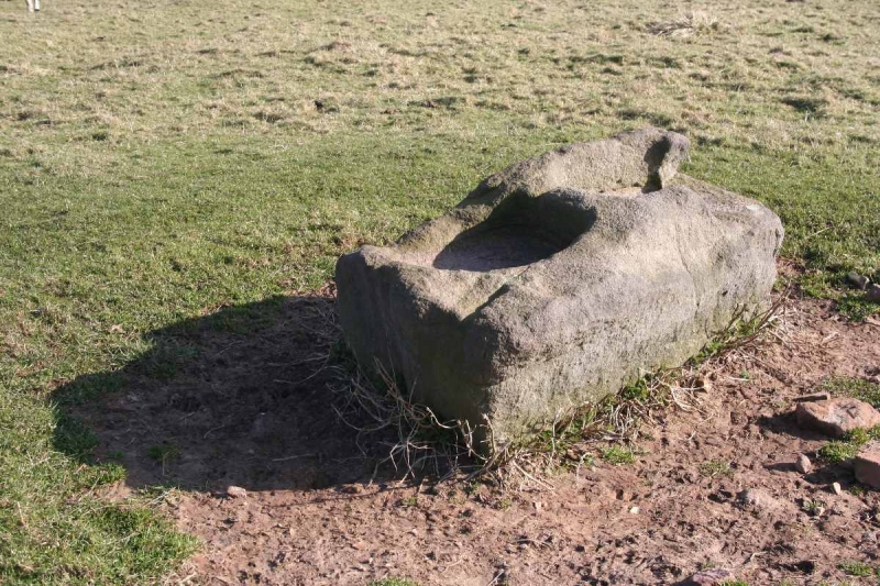
The monument is located on the edge of Whaley Moor in the north western
gritstone moorlands of the Derbyshire Peak District and is the base or socle
of a twin-shafted wayside and boundary cross. It comprises a natural earthfast
gritstone boulder which has been roughly dressed in situ to create a
wedge-shaped slab. Cut into the surface are two rectangular socket holes which
would, originally, have housed twin cross shafts. The shafts and their cross
heads are now missing, possibly due to the activities of 16th or 17th century
iconoclasts.
The north socket measures 47cm north-south by 38cm east-west while the south
socket, which is broken on its south side and south west corner, originally
measured 43cm north-south by 31cm east-west. The sockets are set c.10cm apart.
The socle is undecorated but has faint tool marks visible on all faces. Its
maximum length is 140cm and its maximum width is 84cm across the north end
narrowing to 49cm at its south end.
Generally it stands c.60cm high though, at the south east corner, it is 65cm
high. The monument is one of a group of early medieval twin-socketed crosses
situated near the border between Derbyshire and Cheshire which are thought not
only to mark ancient routes across the moors but also boundaries between
adjoining districts. The precise origin of the name Dipping Stone is unknown
but it is likely to be a reference to a tradition of baptisms being carried
out at the stone as this practice is said to have occurred at other sites
where medieval cross bases have survived long after their shafts have gone.
Alternatively it may indicate that goods and money were exchanged at the stone
during times of plague as the practice of leaving such articles in hollows
filled with vinegar is also recorded at other sites. This may serve to explain
the origin of the alternative name for the cross base, the Plague Stone.
MAP EXTRACT
The site of the monument is shown on the attached map extract.
It includes a 2 metre boundary around the archaeological features,
considered to be essential for the monument's support and preservation.
Source: Historic England
Wayside crosses are one of several types of Christian cross erected during the
medieval period, mostly from the 9th to 15th centuries AD. In addition to
serving the function of reiterating and reinforcing the Christian faith
amongst those who passed the cross and of reassuring the traveller, wayside
crosses often fulfilled a role as waymarkers, especially in difficult and
otherwise unmarked terrain. The crosses might be on regularly used routes
linking ordinary settlements or on routes having a more specifically religious
function, including those providing access to religious sites for parishioners
and funeral processions, or marking long-distance routes frequented on
pilgrimages.
Over 350 wayside crosses are known nationally, concentrated in south west
England throughout Cornwall and on Dartmoor where they form the commonest type
of stone cross. A small group also occurs on the North York Moors. Relatively
few examples have been recorded elsewhere and these are generally confined to
remote moorland locations.
Outside Cornwall almost all wayside crosses take the form of a `Latin' cross,
in which the cross-head itself is shaped within the projecting arms of an
unenclosed cross. In Cornwall wayside crosses vary considerably in form and
decoration. The commonest type includes a round, or `wheel', head on the faces
of which various forms of cross or related designs were carved in relief or
incised, the spaces between the cross arms possibly pierced. The design was
sometimes supplemented with a relief figure of Christ and the shaft might bear
decorative panels and motifs. Less common forms in Cornwall include the
`Latin' cross and, much rarer, the simple slab with a low relief cross on both
faces. Rare examples of wheel-head and slab-form crosses also occur within the
North York Moors group. Most wayside crosses have either a simple socketed
base or show no evidence for a separate base at all.
Wayside crosses contribute significantly to our understanding of medieval
religious customs and sculptural traditions and to our knowledge of medieval
routeways and settlement patterns. All wayside crosses which survive as earth-
fast monuments, except those which are extremely damaged and removed from
their original locations, are considered worthy of protection.
The Dipping Stone is a good example of an early medieval wayside cross which
also functioned as a boundary marker. Though lacking its shafts and cross
heads, it is reasonably well preserved and is important as one of the regional
group of twin-socketed wayside crosses which also includes the Bow Stones and
Robin Hood's Picking Rods.
Source: Historic England
Books and journals
Cox, C, 'The Athenaeum' in Early Crosses in the High Peak, (1904), 562
Green, C, 'Transactions of the Lancashire & Cheshire Antiquarian Society' in , , Vol. 56, (1941), 114-20
Phillips, C W, 'Antiquity' in Antiquity, , Vol. XI, (1937), 294-299
Other
Shackleton Hill, Angela, (1994)
Source: Historic England
Other nearby scheduled monuments