Approximate Location Map
Large Map »
This site is entirely user-supported. See how you can help.
Latitude: 54.162 / 54°9'43"N
Longitude: -2.765 / 2°45'54"W
OS Eastings: 350143.043938
OS Northings: 474286.042116
OS Grid: SD501742
Mapcode National: GBR 9N49.5T
Mapcode Global: WH83N.HNJ7
Entry Name: Round cairn on Summerhouse Hill
Scheduled Date: 25 January 1927
Last Amended: 1 August 1994
Source: Historic England
Source ID: 1009119
English Heritage Legacy ID: 23730
County: Lancashire
Civil Parish: Yealand Conyers
Traditional County: Lancashire
Lieutenancy Area (Ceremonial County): Lancashire
Church of England Parish: Yealand Conyers St John The Evangelist
Church of England Diocese: Blackburn
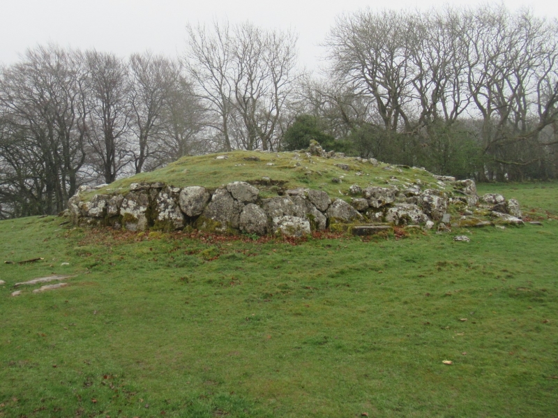
The monument is a round cairn located a short distance east of the summit
plateau of Summerhouse Hill. It includes an oval mound of turf covered earth
and limestone rubble up to 0.6m high with maximum dimensions of 12.5m
north-south by 9.4m east-west. The cairn is kerbed with limestone blocks
around its perimeter. At the monument's centre is a circular depression 2.5m
in diameter by 0.3m deep which marks the site of an antiquarian investigation
undertaken in 1778. This investigation located a human skeleton adjacent to
which was found a large blue bead and an urn containing calcined human bones.
MAP EXTRACT
The site of the monument is shown on the attached map extract.
It includes a 2 metre boundary around the archaeological features,
considered to be essential for the monument's support and preservation.
Source: Historic England
Round cairns are prehistoric funerary monuments dating to the Bronze Age
(c.2000-700 BC). They were constructed as stone mounds covering single or
multiple burials. These burials may be placed within the mound in stone-lined
compartments called cists. In some cases the cairn was surrounded by a ditch.
Often occupying prominent locations, cairns are a major visual element in the
modern landscape. They are a relatively common feature of the uplands and are
the stone equivalent of the earthen round barrows of the lowlands. Their
considerable variation in form and longevity as a monument type provide
important information on the diversity of beliefs and social organisation
amongst early prehistoric communities. They are particularly representative of
their period and a substantial proportion of surviving examples are considered
worthy of protection.
Despite limited antiquarian investigation of the monument, the round cairn on
Summerhouse Hill survives reasonably well. This investigation located human
remains, pottery and a bead, and further evidence of interments and grave
goods will exist within the cairn and upon the old landsurface beneath.
Source: Historic England
Books and journals
Stone, J W, 'Archaeologia' in Archaeologia , , Vol. 7, (1785), 414
Other
Darvill, T, MPP Single Monument Class Descriptions - Bowl Barrows, (1989)
Source: Historic England
Other nearby scheduled monuments