Approximate Location Map
Large Map »
This site is entirely user-supported. See how you can help.
Latitude: 51.5768 / 51°34'36"N
Longitude: -1.567 / 1°34'1"W
OS Eastings: 430102.892483
OS Northings: 186529.120835
OS Grid: SU301865
Mapcode National: GBR 5WW.0N7
Mapcode Global: VHC0Z.SMGK
Entry Name: Bronze Age bowl barrow and a pair of Anglo-Saxon burial mounds 70m south of the White Horse on Whitehorse Hill
Scheduled Date: 30 November 1995
Source: Historic England
Source ID: 1008411
English Heritage Legacy ID: 21777
County: Oxfordshire
Civil Parish: Uffington
Traditional County: Berkshire
Lieutenancy Area (Ceremonial County): Oxfordshire
Church of England Parish: Uffington
Church of England Diocese: Oxford
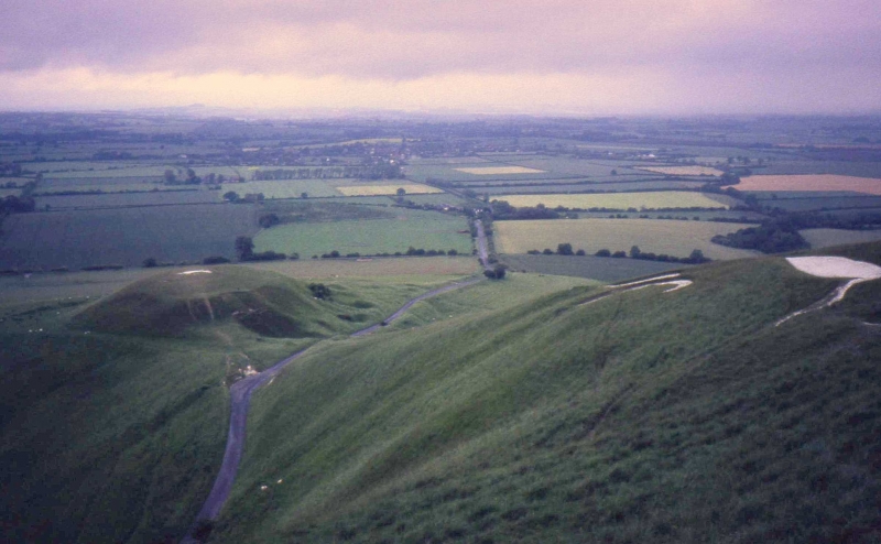
The monument includes a small Bronze Age bowl barrow and two Anglo-Saxon
hlaews (burial mounds), aligned south west to north east, and situated 70m
south of the White Horse and c.100m north east of Uffington Castle on
Whitehorse Hill, an area that is in the Guardianship of the Secretary of
State. The barrows lie on the top of the hill and overlook a Neolithic long
barrow and Romano British cemetery c.60m to the west.
The Bronze Age barrow mound, which is situated at the south west end of the
group, measures 11m in diameter and stands up to 0.15m high. Surrounding the
mound is a quarry ditch from which material was obtained during the
construction of the monument. This has become infilled over the years and is
now only visible at ground level as a slight depression to the north and west
of the barrow. Recent excavation has shown it to survive as a buried feature
c.2m wide. The mound has been cut by later Roman features from which
artefacts, including metal work, have been recovered. The two Anglo-Saxon
hlaews are difficult to locate at ground level but they have been plotted by a
recent geophysical survey as being c.11m apart and each having a diameter of
9m. Although the mounds have been levelled, the Saxon ground surface and all
features cut into it, for example burial pits, will survive below the present
ground level. These barrows did not have quarry ditches but were built from
material collected from nearby.
MAP EXTRACT
The site of the monument is shown on the attached map extract.
It includes a 2 metre boundary around the archaeological features,
considered to be essential for the monument's support and preservation.
Source: Historic England
Bowl barrows, the most numerous form of round barrow, are funerary monuments
dating from the Late Neolithic period to the Late Bronze Age, with most
examples belonging to the period 2400-1500 BC. They were constructed as
earthen or rubble mounds, sometimes ditched, which covered single or multiple
burials. They occur either in isolation or grouped as cemeteries and often
acted as a focus for burials in later periods. Often superficially similar,
although differing widely in size, they exhibit regional variations in form
and a diversity of burial practices. There are over 10,000 surviving bowl
barrows recorded nationally (many more have already been destroyed), occurring
across most of lowland Britain. Often occupying prominent locations, they are
a major historic element in the modern landscape and their considerable
variation of form and longevity as a monument type provide important
information on the diversity of beliefs and social organisations amongst early
prehistoric communities. They are particularly representative of their period
and a substantial proportion of surviving examples are considered worthy of
protection.
The Bronze Age bowl barrow 70m south of the White Horse on Whitehorse Hill has
survived despite being small in size. Our understanding of its form and
function has been increased by recent partial excavation and geophysical
survey.
Hlaews are burial monuments of Anglo-Saxon or Viking date and comprise a
hemispherical mound of earth and redeposited bedrock constructed over a
primary burial or burials. These were usually inhumations, buried in a grave
cut into the subsoil beneath the mound, but cremations placed on the old
ground surface beneath the mound have also been found. Hlaews may occur in
pairs or in small groups; a few have accompanying flat graves. Constructed
during the pagan Saxon and Viking periods for individuals of high rank, they
served as visible and ostentatious markers of their social position. Some were
associated with territorial claims and appear to have been specifically
located to mark boundaries. They often contain objects which give information
on the range of technological skill and trading contacts of the period.
Only between 50 and 60 hlaews have been positively identified in England. As a
rare monument class all positively identified examples are considered worthy
of preservation.
The pair of hlaews forming part of this monument are situated in an area which
includes archaeological remains relating to burial practice spanning the
Neolithic, Bronze Age, Roman and Anglo-Saxon periods and as such are part of
an unusual example of changing burial practices, within a discrete location.
Source: Historic England
Other
Ancient Monuments Laboratory, White Horse Hill Mounds, 1993, Unpublished plots
Ancient Monuments Laboratory, White Horse Hill Mounds, 1993, Unpublished plots
Excavation report, Palmer, S, Uffington White Horse Hill 1993, (1993)
Letter to P. Jeffery 16/08/1993, Palmer, S., Uffington White Horse Hill - MPP, (1993)
OXON PRN 10,730, C.A.O., Oblong Mound, (1983)
unpublished plots, Ancient Monuments Laboratory, Summary of Magnetic Susceptibility Tests, (1993)
With S. Palmer - interpretation, JEFFERY, P., DISCUSSION ON SITE, (1993)
With S. Palmer - interpretation, JEFFERY, P., On Site Discussion, (1993)
Source: Historic England
Other nearby scheduled monuments