Approximate Location Map
Large Map »
This site is entirely user-supported. See how you can help.
Latitude: 51.3126 / 51°18'45"N
Longitude: -1.3446 / 1°20'40"W
OS Eastings: 445775.963063
OS Northings: 157255.3633
OS Grid: SU457572
Mapcode National: GBR 82X.NVP
Mapcode Global: VHCZX.N80M
Entry Name: Large univallate hillfort at Beacon Hill
Scheduled Date: 30 November 1925
Last Amended: 15 April 1994
Source: Historic England
Source ID: 1008037
English Heritage Legacy ID: 24318
County: Hampshire
Civil Parish: Burghclere
Traditional County: Hampshire
Lieutenancy Area (Ceremonial County): Hampshire
Church of England Parish: Highclere St Michael and All Angels
Church of England Diocese: Winchester
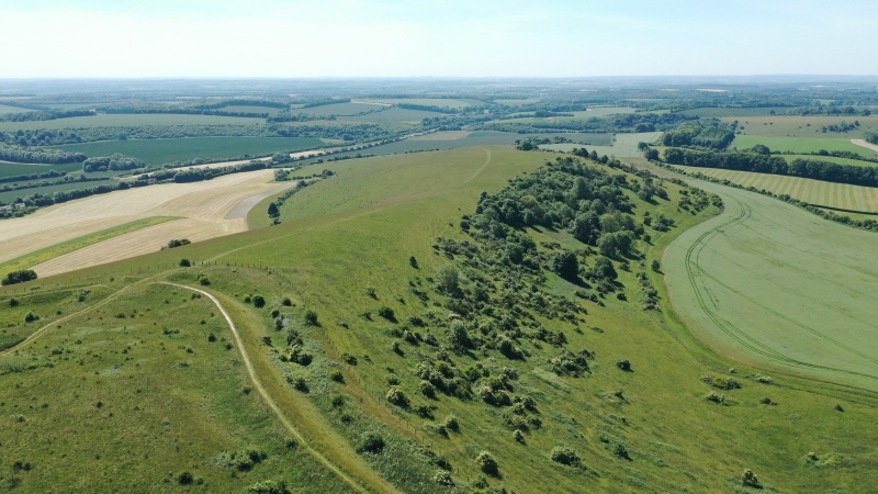
The monument includes a large univallate Iron Age hillfort situated on the
summit of Beacon Hill, a ridge of Upper Chalk south of the Kennet valley.
Following the contours of the hill, the hillfort measures 300m internally from
north-west to south-east. It has a maximum internal width of 190m at the
western end, narrowing to 95m at the centre and thereafter broadening again to
160m. An area of 3.84 hectares is enclosed by the earthen rampart and ditch.
The rampart rises up to 2.5m above the interior of the hillfort. The ditch,
which is up to 12m wide and falls to a maximum depth of 6m below the apex of
the rampart, is flanked by a counterscarp rampart up to 2.5m high. The single
surviving entrance at the south-east corner of the hillfort has hornworks and
an inturned corridor. There is an indication of a second entrance,
deliberately blocked, toward the north-western corner of the hillfort.
The interior has not been ploughed and contains many low earthworks. Some,
representing hut sites, are in the form of circular or sub-circular banks or
platforms with banks, all with external ditches. Other less regular platforms
and depressions are also preserved. Large, irregular quarry pits flank the
inner side of the ramparts except at the entrance and possible blocked
entrance.
Two short lengths of bank and ditch on the highest part of the hill pre-date
the internal development of the hillfort but have not been accurately dated.
Small-scale excavation in 1912 investigated one hut circle and three pits. One
pit had been reused by men tending the post-medieval beacon situated on the
highest part of the hill.
The tomb of the fifth Earl of Carnarvon is set above ground in a levelled and
fenced enclosure in the south-western corner of the hillfort.
Excluded from the scheduling are all fences, fenceposts, the tomb of the Earl
of Carnarvon and the associated railings and gate, and the Ordnance Survey
trigonometry pillar, but the ground beneath all these features is included.
MAP EXTRACT
The site of the monument is shown on the attached map extract.
It includes a 2 metre boundary around the archaeological features,
considered to be essential for the monument's support and preservation.
Source: Historic England
Large univallate hillforts are defined as fortified enclosures of varying
shape, ranging in size between 1ha and 10ha, located on hilltops and
surrounded by a single boundary comprising earthworks of massive proportions.
They date to the Iron Age period, most having been constructed and used
between the fourth century BC and the first century AD, although evidence for
earlier use is present at most sites. The size of the earthworks reflects the
ability of certain social groups to mobilise the labour necessary for works on
such a monumental scale, and their function may have had as much to do with
display as defence. Large univallate hillforts are also seen as centres of
redistribution, both for subsistence products and items produced by craftsmen.
The ramparts are of massive proportions except in locations where steepness of
slope precludes easy access. They can vary between 6m and 20m wide and may
survive to a height of 6m. The ditches can measure between 6m and 13m wide and
between 3m and 5m deep. Access to the interior is generally provided by one or
two entrances which often take the form of long passages formed by inturned
ramparts and originally closed by a gate located towards the inner end of the
passageway. The entrance may be flanked by guardrooms and/or accompanied by
outworks. Internal features often include round-houses as well as small
rectangular and square structures supported by four to six postholes and
interpreted as raised granaries. When excavated, the interior areas exhibit a
high density of features, including post- and stakeholes, gullies, floors,
pits, hearths and roads. Large univallate hillforts are rare with between 50
and 100 examples recorded nationally. Most are located within southern England
where they occur on the chalklands of Wessex, Sussex and Kent. The western
edge of the distribution is marked by scattered examples in north Somerset and
east Devon, while further examples occur in central and western England and
outliers further north. Within this distribution considerable regional
variation is apparent, both in their size, rampart structure and the presence
or absence of individual components. In view of the rarity of large
univallate hillforts and their importance in understanding the organisation
and regional structure of Iron Age society, all examples with surviving
archaeological potential are believed to be of national importance.
The large univallate hillfort at Beacon Hill displays excellent preservation
both of the defences and, because of the absence of plough damage, of an array
of interior earthwork features. Limited excavation has indicated that the site
contains archaeological and environmental evidence relating to the
construction, use and abandonment of the monument. This monument was recently
the subject of a full survey by the Royal Commission on the Historical
Monuments of England.
Source: Historic England
Books and journals
Eagles, B N, 'Archaeol J' in A New Survey of the Hillfort on Beacon Hill, , Vol. 148, (1991), 98-103
Woolley, L, 'Man' in Excavations on Beacon Hill, Hampshire, , Vol. 13, (1913), 8-10
Source: Historic England
Other nearby scheduled monuments