Approximate Location Map
Large Map »
This site is entirely user-supported. See how you can help.
Latitude: 54.5951 / 54°35'42"N
Longitude: -2.7941 / 2°47'38"W
OS Eastings: 348785.024023
OS Northings: 522497.602645
OS Grid: NY487224
Mapcode National: GBR 8HX9.WL
Mapcode Global: WH81J.1RQQ
Entry Name: Round cairn 580m north east of The Cockpit, Askham Fell
Scheduled Date: 30 November 1925
Last Amended: 25 July 1995
Source: Historic England
Source ID: 1007369
English Heritage Legacy ID: 22519
County: Cumbria
Civil Parish: Barton
Traditional County: Westmorland
Lieutenancy Area (Ceremonial County): Cumbria
Church of England Parish: Askham with Lowther
Church of England Diocese: Carlisle
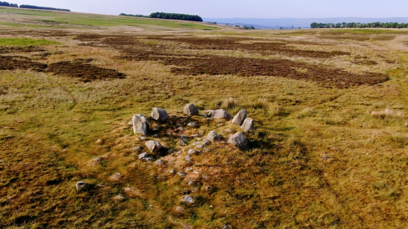
The monument is a round cairn located on Askham Fell, 580m north east of The
Cockpit stone circle. It includes a slightly oval mound of largely
turf-covered stones up to 0.4m high with maximum dimensions of 5.4m by 5.3m.
There is a small central depression in the top of the cairn with some
earthfast stones protruding.
MAP EXTRACT
The site of the monument is shown on the attached map extract.
It includes a 2 metre boundary around the archaeological features,
considered to be essential for the monument's support and preservation.
Source: Historic England
Round cairns are prehistoric funerary monuments dating to the Bronze Age
(c.2000-700 BC). They were constructed as stone mounds covering single or
multiple burials. These burials may be placed within the mound in stone-lined
compartments called cists. In some cases the cairn was surrounded by a ditch.
Often occupying prominent locations, cairns are a major visual element in the
modern landscape. They are a relatively common feature of the uplands and are
the stone equivalent of the earthen round barrows of the lowlands. Their
considerable variation in form and longevity as a monument type provide
important information on the diversity of beliefs and social organisation
amongst early prehistoric communities. They are particularly representative of
their period and a substantial proportion of surviving examples are considered
worthy of protection.
Despite some surface disturbance to the centre of the monument, the round
cairn 580m north east of The Cockpit survives reasonably well and will contain
undisturbed archaeological deposits within the mound and upon the old
land surface beneath. The monument lies within an area of open fell rich in
prehistoric monuments, and is situated upon an alignment of funerary monuments
stretching for over 1.5km along the natural communication route over a col
between Lowther and Ullswater valleys. It thus indicates the importance of
this area in prehistoric times and the diversity of monument types to be
found here. The monument will contribute to the study of the ceremonial
function of cairns and other spatially associated monuments in the area.
Source: Historic England
Books and journals
Quartermaine, J, Askham Fell Survey Catalogue, (1992), 23-4
Quartermaine, J, Askham Fell Survey Catalogue, (1992), 25
Other
Darvill,T., MPP Single Monument Class Description - Bowl Barrows, (1988)
SMR No, Cumbria SMR, Moor Divock, (1985)
Source: Historic England
Other nearby scheduled monuments