Approximate Location Map
Large Map »
This site is entirely user-supported. See how you can help.
Latitude: 54.7475 / 54°44'51"N
Longitude: -3.4511 / 3°27'4"W
OS Eastings: 306689.5282
OS Northings: 540140.912006
OS Grid: NY066401
Mapcode National: GBR 4FBJ.MX
Mapcode Global: WH5Y4.YXSV
Entry Name: Allonby saltpan
Scheduled Date: 20 November 1975
Source: Historic England
Source ID: 1007256
English Heritage Legacy ID: CU 22
County: Cumbria
Civil Parish: Crosscanonby
Traditional County: Cumberland
Lieutenancy Area (Ceremonial County): Cumbria
Church of England Parish: Cross Canonby St John the Evangelist
Church of England Diocese: Carlisle
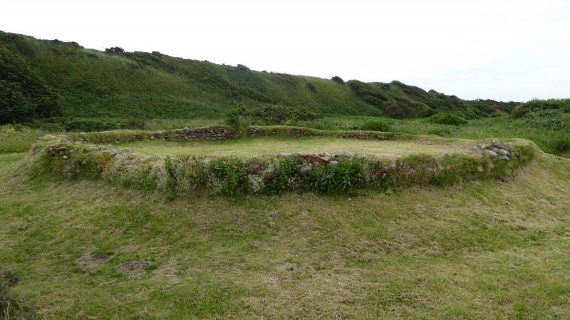
Salt pan, 275m south west of Swarthy Hill.
Source: Historic England
This record was the subject of a minor enhancement on 23 February 2016. This record has been generated from an "old county number" (OCN) scheduling record. These are monuments that were not reviewed under the Monuments Protection Programme and are some of our oldest designation records.
The monument includes the remains of a saltpan of post-medieval date, situated along a stretch of coastline overlooked from the north east by Swarthy Hill. The scheduled remains include a large circular tank with a diameter of 17.8m surrounded by a sea cobble and boulder wall varying in width from 0.7m to 1m and with an entrance on its east side reinforced with sandstone blocks. Local records indicated that the saltpans were set up by the Senhouse family and were in operation from at least 1684 until about 1790 when the salt pan closed under competition from the Cheshire rock salt industry.
Further archaeological remains exist within the vicinity of this monument, but are not included because they have not been assessed.
Source: Historic England
Salt has been produced from sea water or, in inland areas, from brine springs since before Roman times, and the technology used in the medieval period displays a marked continuity with earlier production methods. Brine, from which the water was evaporated to produce the salt, was collected in one of two ways, either by its filtration from coastal sand, soil or pebbles impregnated with salt water during high tides and periodic inundation, or by its collection in pools or pits filled at high tide or by inland springs, sometimes by way of a system of channels, dams and sluices. Medieval salterns include a range of features connected with the collection and evaporation processes, of which the most visually distinctive are the oval or kidney-shaped middens of waste material which may cover areas of 2ha or more. Other features usually survive in buried form beneath and around the middens, illustrating the fact that salterns were often in use for periods of at least a century, during which time they were occupied seasonally, their component structures being rebuilt at the beginning of each summer or as required. Evaporation was often aided by an evaporation kiln fuelled by peat or wood products, of which several different types are known, and the remains of temporary wooden buildings, wooden or wicker troughs and clay-lined pits have also been found during excavation. Salt was an expensive commodity during the medieval period, particularly in demand for food preservation and curing. Salterns are known from documentary sources and place name evidence to have been widely distributed around the English coast and the inland brine springs of Cheshire from at least the end of the 11th century. The industry had declined by the beginning of the 16th century and competition with the superior and cheaper rock salt, mined from the beginning of the 17th century, led to its demise during the early post- medieval period.
The salt pan 275m south west of Swarthy Hill is well-preserved and is an excellent example of an earlier post-medieval salt pan. As such the monument represents the final form of the industry before it was replaced by mining for rock salt. In addition to the above ground remains, the monument will contain below ground archaeological deposits relating to the construction, use and abandonment of the site. The monument provides insight into salt producing industry during an important transformative period. The significance of the site is increased by its position within a landscape littered with archaeological remains several of which lye in close proximity such as the Iron Age hillfort on Swarthy Hill and the Roman Swarthy Hill Milefort, which lies close to the SSE.
Source: Historic England
Other
PastScape Monument No:- 9147
Source: Historic England
Other nearby scheduled monuments