Approximate Location Map
Large Map »
This site is entirely user-supported. See how you can help.
Latitude: 51.3147 / 51°18'52"N
Longitude: -0.5857 / 0°35'8"W
OS Eastings: 498661.6826
OS Northings: 158231.894502
OS Grid: SU986582
Mapcode National: GBR FBK.GQN
Mapcode Global: VHFV7.S7P0
Entry Name: Goldsworth or Langman's Bridge, Basingstoke Canal
Scheduled Date: 7 October 1977
Source: Historic England
Source ID: 1005926
English Heritage Legacy ID: SU 168
County: Surrey
Electoral Ward/Division: Goldsworth Park
Built-Up Area: Woking
Traditional County: Surrey
Lieutenancy Area (Ceremonial County): Surrey
Church of England Parish: Goldsworth Park
Church of England Diocese: Guildford
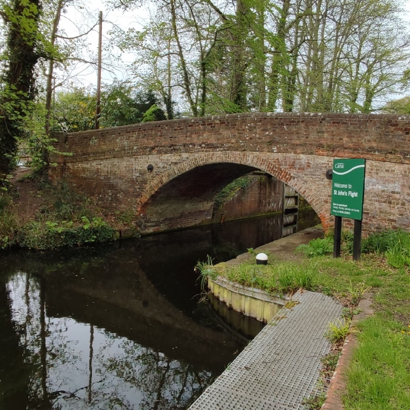
Goldsworth Bridge on the Basingstoke Canal, 71m south-west of Langman’s House.
Source: Historic England
This record was the subject of a minor enhancement on 11 December 2014. The record has been generated from an "old county number" (OCN) scheduling record. These are monuments that were not reviewed under the Monuments Protection Programme and are some of our oldest designation records.
The monument includes a bridge over the Basingstoke Canal, built in about 1790, known variably as Goldsworth Bridge and Langman’s Bridge. It is situated on Langman’s Lane, to the east of a flight of locks known as St John’s flight. The bridge is constructed as a single semi-circular arch of red brick and measures about 12m across and 3m wide. There are parapets of convex shape on both sides. The bridge formed part of the original build of the Basingstoke Canal completed in 1794, which connected Basingstoke with the River Thames at Weybridge via the Wey navigation.
Source: Historic England
Inland navigation using rivers originated in Britain in the prehistoric period and continues in use to the present day. From the Roman period, both canals (artificial waterways constructed primarily for navigation purposes) and river navigations (improvements to existing waterways to make navigation easier) were constructed, and medieval canals such as the navigable dykes dug by the monks in Holderness or the Exeter Canal are known. Although the advantages of canals and inland waterways for the inexpensive and safe means of transporting heavy, bulky or fragile goods had long been recognised elsewhere in Europe, it was not until 1759 that the principal age of canal building began in England began, with the construction of the Bridgewater Canal from Worsley to Manchester. Over the next 70 years canals played an important part in the growth of industry and the expansion of trade in many parts of the country. Canals also facilitated the relatively rapid movement of bulk agricultural produce from the countryside to the rapidly expanding industrial towns of the north and midlands. Canal construction brought with it the requirement for a whole range of associated structures. Many of these, such as bridges, canal workers' houses, warehouses, wet docks, dry docks, locks and water management systems involved the modification and development of the existing designs of such structures to meet the new requirements of the Canal Age. The great age of canals lasted until about the 1840s, when their utility was eroded by the huge expansion of railways with their quick and cheap transportation of people and goods. During their relatively brief period of use, however, canals became the most important method of industrial transportation, making a major contribution to England's Industrial Revolution. Surviving remains of the early industrial waterways transport network are particularly important both by virtue of their rarity and representivity.
The Basingstoke Canal was built by John Smeaton with the assistance of John Jessops, two civil engineers of considerable importance. The canal was significant as one of the first agricultural waterways, designed primarily to stimulate agricultural development in Hampshire. Canals had previously been developed in the growing industrial areas around Leeds and Birmingham. However the Basingstoke Canal was particularly significant in opening up the countryside. The canal was used to transport agricultural goods and timber towards London, whilst bring back coal.
Goldsworth Bridge is a relatively rare, largely unaltered brick-built accommodation bridge. It is a good example of its type and an important representative structure surviving along what was a highly significant stretch of canal.
Source: Historic England
Websites
‘The Canal Story: The early days’, accessed 4 March 2008 from http://www.basingstoke-canal.org.uk/history.htm
Other
Surrey HER 3752. NMR SU95NE13. PastScape 250766.
Source: Historic England
Other nearby scheduled monuments