Approximate Location Map
Large Map »
This site is entirely user-supported. See how you can help.
Latitude: 52.2247 / 52°13'28"N
Longitude: 1.3447 / 1°20'41"E
OS Eastings: 628536.976789
OS Northings: 263770.217177
OS Grid: TM285637
Mapcode National: GBR WNN.JSR
Mapcode Global: VHLB4.8B8X
Entry Name: Framlingham Castle and its associated landscape including the mere, town ditch and Anglo-Saxon cemetery
Scheduled Date: 7 August 1916
Last Amended: 15 May 2014
Source: Historic England
Source ID: 1002965
English Heritage Legacy ID: SF 3
County: Suffolk
Civil Parish: Framlingham
Built-Up Area: Framlingham
Traditional County: Suffolk
Lieutenancy Area (Ceremonial County): Suffolk
Church of England Parish: Framlingham St Michael
Church of England Diocese: St.Edmundsbury and Ipswich
Framlingham Castle, built in early C12 by Roger Bigod, with notable alterations in C13, C16, C17, C18 and in modern times.
Source: Historic England
Framlingham Castle is situated within the small historic market town of Framlingham in north-east Suffolk. It sits at 42m above sea level on rising ground at the south-eastern limit of the Suffolk uplands. The Castle is located on slightly higher ground at the northern end of the medieval town; its position means that it dominates both the town and the mere to the west.
PRINCIPAL ELEMENTS
The scheduling includes the Castle and its associated landscape along with the standing, earthwork and buried remains of the current Castle and its predecessors, the gatehouse, outer bailey, outer and inner ditch, lower court, town ditch and the mere. Also included within the scheduled area is an Anglo-Saxon cemetery.
The current approach to the Castle is the original access to the stone built Castle which would have passed through the initial defences; the outer ditch and Castle bailey. The outer bailey survives as a roughly kidney shaped area, east and south of the stone castle and is defined by a bank and deep ditch, much of which survives within light woodland. The south-west section of the bailey, to the west of the access track to the Castle is currently used as a bowling green, car park, a small garden and the ticket office for the Castle. Any archaeological features in this area are not clearly evident on the surface although given that castle baileys generally contained a wide range of structures, the potential for significant, stratified deposits to survive beneath the ground is very high. The ditch defining the bailey is U-shaped in profile and measures c.30m wide; it is c.4.4m lower than the outside ground surface and c.6.4m below the level of the bailey. The ditch was at some time dammed in the south east quadrant, to form a large ornamental water-filled pond or canal. The dam also serves as a path from the ‘Back Meadow’ into the bailey. A second dam has been built at the southern end of the water filled section and recent garden activity here suggests it is built of rubble construction, certainly in the upper levels. South-west of the water filled area the bailey ditch lies within private gardens, beneath the Castle Inn and the road; the only exception to this is the town pond, adjacent to the entrance to the Castle, the scarps of which are adapted from the original ditch. Within the private gardens earthworks indicate that the northern edge of the ditch survives and that the houses on the northern side of Castle Street have been terraced into the southern bank of the ditch. The majority of the houses here are of C16 or C17 date.
The potential for both the water-filled areas and the dry sections of the bailey ditch to retain waterlogged, historic environmental data and possibly organic artefacts such as wood or leather is very high. The depth of the ditch means that some waterlogging occurs even in the dry sections and will provide ideal, anaerobic conditions for the survival of such deposits in the buried silts.
The town ditch is believed to pre-date the current Castle and possibly functioned as the boundary of an Anglo-Saxon manorial complex or the first castle to be built on the site in the early C12. It survives as a ditch c.11m wide and c.1.1m deep with a bank c.4m wide on the inside edge of the ditch. The ditch is visible around the northern and eastern edge of the Castle, outside the outer defence ditch; on the northern side it forms the Back Meadow between the two. The internal bank is most prominent in the garden of 31 Castle Street where it separates the bailey ditch from the town ditch and the town ditch functions as a field drain. Further south-west the remaining ditch has been lost in the post-medieval development of this part of the town. Further evidence of Anglo-Saxon occupation within the area encompassed by the town ditch comes from the recorded discovery of a cemetery where about 50 burials were uncovered beneath the entrance to the Norman stone Castle and clearly predates it. Pottery found close to the burials is believed to date to the Middle-Saxon period (AD 650-850).
That there was a castle in Framlingham before the present one is certain as the demolition of a castle, as a punishment for rebellion, was recorded in the Pipe Rolls for 1174-5 and 1175-6. The demolition by the king's engineer is understood to have included the destruction of the defensive works and the filling in of a moat. Excavations by Coad in 1972 cut an intermittent section across the whole inner bailey, from the Poor House to the eastern edge of the curtain wall, and revealed 6m depth of archaeological deposits representing an earlier moat probably related to a motte, ringwork or platform in the northern half of the inner castle bailey. Dating evidence suggests the destruction of this feature took place in the second half of the C12. It is not uncommon for castles to be built on the site of a previous Saxon manorial complex and based on the evidence this seems very likely at Framlingham. The sequence of construction and destruction over the centuries will be reflected in the archaeological deposits both within the inner Castle walls and the outer bailey where the archaeological potential of the monument is considerable.
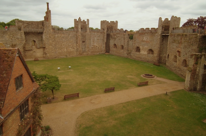
There is a strong possibility that the early C12 Castle at Framlingham had a relatively short life span being constructed about 1140 and demolished in the 1170s. This was followed by a period of two or three decades without any Castle on the site and it is to this period that the first stone hall and chapel, evidence for which survives in the east wall of the Castle, probably belonged. Although the inner court now appears relatively devoid of structures, timber, stone and, in the Tudor period, brick buildings once stood within the bounds of the walls and indeed lined the walls, creating further enclosed courts. Many of the buildings remained until the C17. Evidence for all these structures and the sequence of construction survives in both the standing remains and the buried archaeological deposits.
The only buildings remaining inside the Castle walls today are the Poor House and the Red House. Framlingham’s Poor House, which provided work and lodgings for the town's paupers from the C17 to the C19 centuries, was built around the shell of the Castle’s medieval great hall which stood from the late C12 to the C17. South of the Poor House is the Red House which was built c.1660 and served as the first poorhouse and is thought to have replaced the service wing of the medieval hall. It is now a dwelling. The ground beneath these buildings retains important stratified deposits pertaining to the construction and evolution of the Castle and its related structures.
The stone Castle sits on a platform surrounded by a large ditch on the north, east and south sides. The platform rises between 6.4m and 10.7m above the bottom of the ditch and 7.5m above the lower court but is barely higher than the natural ground level of the bailey to the south and east. It is roughly oval in shape c.98m long and 71m wide with a rectilinear south-eastern corner. The slope of the platform is generally steep and even, with some localised soil slippage and erosion mainly where walkers have created paths. A ditch extends around the platform, except on the east where the ground falls steeply to the lower court. It is on average c.25m wide by 8m deep and is fairly uniform in profile. At its southern junction with the lower court there is a steep drop in the level of the ditch. In the north-east section of the ditch are the remains of brick piers from the late-C15 or early-C16 bridge, with decorative chequerboard flushwork in brick and flint.
Beyond the confines of the curtain wall, to the west of the Castle and overlooking the mere, is the lower court. This was an important early feature of the Castle, added after the curtain wall was constructed. It was defended by two towers and walled on all sides and is thought to have housed granaries, barns or stables. The court comprises a roughly rectangular level platform c.59m by 40m, defined by earthen banks on three sides and by the steep scarp of the Castle platform on the east. Geophysical survey has confirmed C13 accounts that the surrounding walls were built of stone (2002). The northern bank of the court stands to 2.6m high and contains the base of a stone turret, part of a postern gate and the remains of a wall connecting these with the main curtain. The wall runs towards the main curtain wall but stops immediately south-west of the mural tower creating what is thought to be a century point. The northern bank also stops short of the western bank leaving c.3.8m gap directly in line with a large block of unfaced masonry, situated partially within the ditch, which is understood to be an abutment for a bridge connecting the lower court with the mere and the park. A small wooden bridge across the field drain now achieves the same purpose.
The southern bank is 3.9m high and at its eastern end are the remains of the Prison Tower and the Postern Gate. These structures connect the bank with the main curtain wall between mural towers. As with the northern wall this is an addition to the curtain wall and was substantially reused with alterations to windows and other openings, primarily during the Tudor period.
A large irregular mound to the south of the southern bank measures c.60.5m by 38.3m and 6.2m high and is defined by the ditches south of the lower court, and those of the bailey. Its function is not clear but it seems likely that its construction followed the addition of the lower court to the castle. The creation of the outwork provides a smooth junction between the extended bailey and the lower court adding strength to an otherwise vulnerable right-angle.
By the C16, the lower court is understood to have been a garden, where guests could walk to the water's edge. By the C18 there were two fishponds in the centre of the lower court, still evident in the late C19. These ponds are evident as slight scarps; one defining a roughly rectilinear area measuring c.21m by c.15.5m and 0.2m deep, and the other as a group of more amorphous scarps.
West of the lower court is the mere, which was probably created during or soon after the construction of the stone castle at the end of the C12. In the C14 it was referred to as the ‘Great Lake beneath the castle’ and it was still functioning as a fishery in the early C17 although it probably ceased to be maintained following the decline of the castle in the later C16.
From a survey carried out in 1997, it is understood that the mere was an artificially dug feature. The old shore line of the mere is quite clearly defined by a single intermittent scarp surviving up to a maximum height of 1m. The scarp defines an elongated kidney-shaped area of 9.38 hectares and survives best to the west and north-east, but part of the southern side is not visible at all. Despite the variable condition, the scarp has an overall cohesion and it is probably the original extent of the mere. On the eastern side, immediately below the lower court, two slight platforms project from the old shoreline into the original mere. The southern one is irregular in shape but measures c.28m by 20m by 0.3m high. The northern one is also irregular and measures c.58.5m by 28.4m by c.0.5m high with parallel scarps on the surface suggesting the site of a structure. A dovecote is known to have existed somewhere in the mere by 1386-7. Another feature extending into the original mere on the south east edge is a bank which is thought to be the base or remains of a small boat landing or jetty that is considered to be a much later feature.
Along the western side of the mere are two parallel lines of willow stumps extending for some 108m within the mere’s present boundary. The stumps are regularly spaced and of a uniform size and condition. These are believed to be the remains of a revetment to the mere bank, whose willow stakes re-rooted once they had been inserted into the ground. A second series of willow stumps, whose line is extended by surviving trees, is evident on the east side of the mere. These run for 24m north-west from the tip of the northern platform. Although the date of both revetments is unknown, a C19 date seems probable but may also be the western shoreline shown on Isaac Johnson's map of 1798.
The area of the former mere is divided into eight meadows by the River Ore and six other drainage channels. All the channels are straight, with the exception of the river, and all still contain some water for part of their length. These channels cut through the old shoreline and were probably originally linked to land drainage features outside the mere. These channels were and indeed remain an essential component of the meadows.
At its western limit the old shore line deviates from its course around an area of higher ground which protrudes into the former mere. At this point a small stream formerly flowed into the mere and the tongue of land may be in part formed by alluvial silt. The area of higher ground contains a number of regular and irregular sunken features. The largest is a rectilinear fishpond, measuring c.28m by c.12m by 1.7m deep with a slight shelf at its western end. There is a similar pond in the Castle ditch north of the lower court of the Castle. The remaining features in this area are difficult to categorise and may have undergone some infilling but they are probably part of a fish-rearing complex of small ponds, channels and robbed-out building foundations, accessible from the lower court.
EXTENT OF SCHEDULING
The scheduled area begins in the north west corner at grid reference TM2836864029, on the eastern edge of New Road. It then follows a field boundary to the north east to meet the southern edge of the public footpath. It follows the footpath to the south east, at least part of which is marked by a field boundary, until it meets Badingham Road. It then follows the western edge of the road south before cutting in to skirt around the rear garden fences of the C20/C21 properties on Badingham Road. It follows the eastern edge of the town ditch into the garden of number 31 Castle Street then cuts through the garden to the rear of the brick built barn curving around to the rear of the other properties on Castle Street, any garden buildings are excluded from the scheduling although the ground beneath is included. Rear extensions to 25-27 and number one Castle Street are excluded from the scheduling although the ground beneath is included. After crossing Church Street the line follows a boundary around the southern edge of the outer bailey ditch before turning south west to follow boundaries around the west and southern sides of the mere. It then follows the eastern edge of New Road until it meets the northern boundary.
There is considerable potential for undesignated (but potentially national important) remains to survive outside the scheduled area, particularly in the developed areas of the town of Framlingham to the south. It was considered that these remains would be most appropriately managed through the planning system and the National Planning Policy Framework.
EXCLUSIONS
There are a number of features which are excluded from the scheduling; all fences, modern path and road surfaces, signage and garden sheds, although the ground beneath all these features is included. Further exclusions from the scheduling are the bowling green pavilion and green, the English Heritage ticket office, car park, the Castle Inn public house, timber and glass refreshment kiosk within the Castle curtain walls, timber bridges and railings. Again, the ground beneath all these features is included.
The Poor House and Red House are most appropriately managed under their Listed Building status and as such are not included in the scheduling although the ground beneath both is included.
Source: Historic England
Framlingham Castle is scheduled for the following principal reasons:
* Survival: for the exceptional standing, buried and earthwork remains, depicting the form, plan and architectural detail of the Castle. The considerable depth of buried deposits is particularly noteworthy and harbours evidence of phases of evolution dating from at least the Anglo-Saxon period;
* Potential: for the stratified archaeological deposits which retain considerable potential to increase our understanding of the Castle. Buried artefacts and sediments will also have the potential to increase our knowledge and understanding of the social and economic functioning of the Castle within the wider medieval landscape;
* Documentation: for the high level of historical documentation pertaining to the Castle's history and genealogy and the archaeological survey and excavation records which document the evolution of the Castle and its associated landscape;
* Diversity: for the range and complexity of surviving features which, taken as a whole, provide a clear plan of the Castle. Such diversity adds to the depth, compexity and significance of the information retained;
* Rarity: the exceptionally well preserved standing and buried remains embody a rare survival of a medieval Castle. The monument represents a very specific period in medieval history when a clearly engrained social hierarchy expressed power both through architectural display and strategic effect;
* Group value: the monument has a strong visual and functional relationship with the listed Poor House and Red House located within the Castle courtyard, and numerous listed buildings along Castle Street.
Source: Historic England
Books and journals
Stacey, N, Framlingham Castle. English Heritage Guidebooks, (2009)
Coad, J G , 'Proceedings of the Suffolk Institute of Archaeology and Natural History' in Recent excavations within Framlingham Castle, , Vol. 32, (1972), 152-163
Knocker, G.M., 'Proceedings of the Suffolk Institute for Archaeology' in Excavations at Framlingham Castle, , Vol. 27, (1956), 65-86
Other
Magnus Alexander, Framlingham Castle, Suffolk. The Landscape Context, 2007,
Martin, L, Framlinham Castle, Framlingham, Suffolk: Report on Geophysical Surveys, 2002,
Moraig Brown, Framlingham Castle, Framlingham, Suffolk, 2002,
Moraig rown and Paul Pattison, Framlingham Mere, Suffolk, Oct 1997,
Suffolk Historic Environment Record,
Source: Historic England
Other nearby scheduled monuments