Approximate Location Map
Large Map »
This site is entirely user-supported. See how you can help.
Latitude: 51.7989 / 51°47'56"N
Longitude: -3.0957 / 3°5'44"W
OS Eastings: 324536
OS Northings: 211706
OS Grid: SO245117
Mapcode National: GBR F2.XW5N
Mapcode Global: VH79C.918S
Entry Name: Pwll Du Tramroad Tunnel Northern Entrances & Site of Lower Rank
Scheduled Date: 30 December 1994
Source: Cadw
Source ID: 297
Cadw Legacy ID: MM224
Schedule Class: Transport
Category: Industrial monument
Period: Post Medieval/Modern
County: Monmouthshire (Sir Fynwy)
Community: Llanfoist Fawr (Llan-ffwyst Fawr)
Traditional County: Monmouthshire
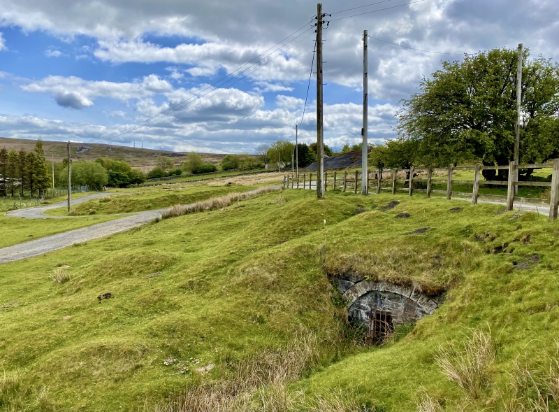
The monument consists of the remains of the northern approach of the Pwll Du tramroad tunnel and the site of Lower Rank, Blaenavon Iron Company housing dating to the 19th century. Pwll Du tunnel carried Hill’s tramroad from the Blaenavon Ironworks through the mountain to Pwll Du, connecting to Pwll Du limestone quarries, Garnddyrys Forge and the Brecknock and Abergavenny Canal. The tunnel probably originated as a mining level which, by 1800, extended 1000m in to the montain. It was connected to Pwll Du by 1815 when it superseded the mountain route from the quarries to the Ironworks. At 2,400m it was the longest tunnel on any British horse-drawn tramroad. The route extended to the canal by 1821 and until the 1860s was the most important transport link to Blaenavon Ironworks. The tunnel is said to have been passable in the 1960s. There were 2 tunnel entrances at the N end, each emerging just E of the metalled road. The N entrance has a stone portal (walled up) and short approach cutting. Above it on the roadside was a cast iron boundary marker of the Blaenavon Company, marked ‘B Co’, although this has now been removed. The S portal appears as a limestone wall roughly 50m to the SE, the arch itself being covered by soil. The area between the 2 portals was the location of Tunnel House, and immediately NNW of the northerly portal is the curving platform where Lower Rank Cottages were located. These 30 houses were mostly built by 1819 and are thought to have been the earliest examples of Blaenavon Iron Company ‘standard’ housing, with sites of outhouses and the tramroad to Tyla quarries in front.
The monument is of national importance for its potential to enhance our knowledge of the development of industrial transportation in the 18th and 19th century. The tunnel, tunnel entrances, track bed, drainage systems, embankments and revetments may all be expected to contain archaeological information in regard to construction techniques and functional detail.
The scheduled area comprises the remains described and areas around them within which related evidence may be expected to survive.
Source: Cadw
Other nearby scheduled monuments