Approximate Location Map
Large Map »
This site is entirely user-supported. See how you can help.
Latitude: 52.8602 / 52°51'36"N
Longitude: -4.1091 / 4°6'32"W
OS Eastings: 258099
OS Northings: 331277
OS Grid: SH580312
Mapcode National: GBR 5Q.RY0G
Mapcode Global: WH55Z.VCGM
Entry Name: Harlech Castle
Scheduled Date:
Source: Cadw
Source ID: 2464
Cadw Legacy ID: ME044
Schedule Class: Defence
Category: Castle
Period: Medieval
County: Gwynedd
Community: Harlech
Built-Up Area: Harlech
Traditional County: Merionethshire
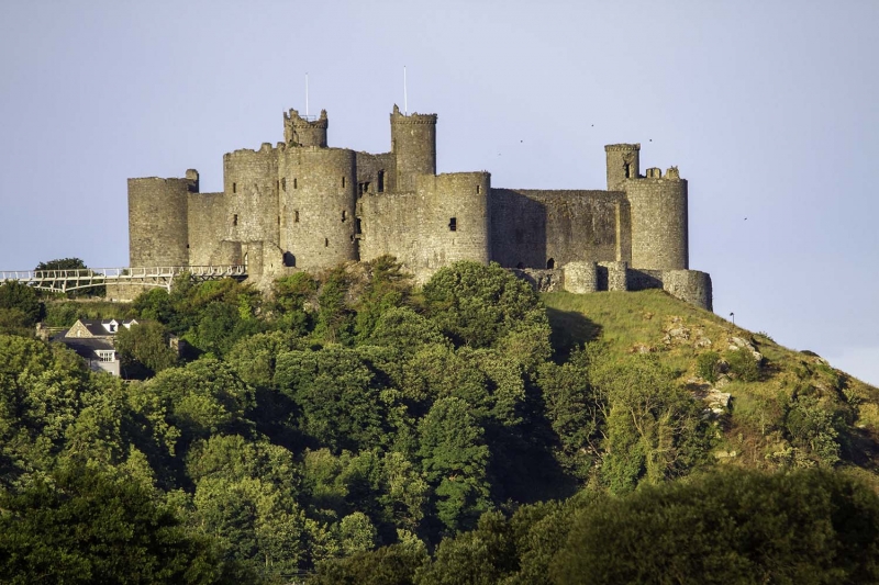
This monument comprises the remains of a medieval castle built by King Edward I. Begun in 1283, the castle occupies a strategic site on a rocky outcrop with commanding views over the sea.
The castle is of concentric type and built out of local Rhinog Grit and yellow sandstone. The main defences consist of four round towers placed at the corners of a roughly rectangular high-walled inner ward, with a lower-walled outer ward forming a narrow secondary line of defence. Beyond this, steep cliffs to the north and west and an artificial ditch to the west and south complete the defences. The outer ward broadly follows the line of the inner ward, though its walls have been reduced in height.
In the centre of the inner ward's eastern (town-facing) wall is a large square gatehouse block and is the only surviving completed example of this form of gatehouse built for Edward I. It consists of a pair of high D-shaped drum towers to the front, and a pair of narrower stair towers to the rear, the latter rising up two stages above the inner ward's corner towers and one stage above the paired front towers.
The gatehouse housed the principal rooms, arranged as lavishly-appointed suites, one on each of the upper floors. The first-floor apartment probably served as the constable's quarters, whilst the upper floor rooms, of rather finer quality of detail, would have been reserved for important visitors. Access to these apartments was from the inner ward. Here an external stone stair, arranged in three straight flights, leads to a round-arched entrance off-centre to the left of the gatehouse's 3-window inner elevation. Various fragmentary fireplaces survive, mostly with stone hoods with decorative corbels. The gatehouse was conceived as an independently defensible unit, and correspondingly could withstand assault from the inner ward, in the event that it fell to the enemy.
The main approach to the castle is in the form of a tunnel entrance between the front towers of the Gatehouse. This leads through to the inner ward via a system of defences including portcullises, gates and murder-holes. The portcullises were operated from the first floor and were therefore under the constable's direct control.
A hall, chapel, service and storage buildings were sited around the north, south and west sides, with the well located against the north wall. Of these buildings, only the walls of the gabled chapel stand to any height; the remainder is reduced to foundation level.
The outer ward has a postern gate, comprising a gateway between small turrets, corbelled-out from the wall; a complex bridge system with further gates and a large drawbridge no longer survives. On the north side is a postern gate with small D-shaped drum towers. This gives access to 'Castle Rock', the rocky plateau which provides the site. A wall runs north-eastwards and curves around and down to protect the rock on this side.
At the foot of the rock, at the north-western point, is the 'Gate-Next-the-Sea', where supplies were landed by ship. This gateway had its own drawbridge and portcullis system and was further covered by two rock-cut engine platforms above. It was linked to the main castle by a walled and defended track (known as the 'Way From the Sea') which winds its way up along the east and south sides of the rock.
Harlech remained in military use for several centuries. It is notable for playing a key role in the events that marked the great Welsh uprising (1400-1414) led by Owain Glyndŵr, during which it served as his residence and court from 1404 until 1409. During the subsequent Wars of the Roses the castle was held by the Welsh Lancastrians before surrendering to the besieging Yorkists (as immortalized in the song ‘Men of Harlech’), and saw its last action during the Civil War, when it was the last mainland British castle to hold out for King Charles I before finally being surrendered in 1647.
This monument is of national and international importance for its potential to enhance our knowledge of medieval social, domestic and political life and warfare. This is reflected by its designation as a World Heritage Site. The scheduled area comprises the remains described and an area around them within which related evidence may be expected to survive.
Source: Cadw
Other nearby scheduled monuments