Approximate Location Map
Large Map »
This site is entirely user-supported. See how you can help.
Latitude: 52.902 / 52°54'7"N
Longitude: -3.5921 / 3°35'31"W
OS Eastings: 293011
OS Northings: 335030
OS Grid: SH930350
Mapcode National: GBR 6D.P9XN
Mapcode Global: WH675.SBP2
Entry Name: Castell Gronw Castle Mound
Scheduled Date:
Source: Cadw
Source ID: 2469
Cadw Legacy ID: ME067
Schedule Class: Defence
Category: Motte
Period: Medieval
County: Gwynedd
Community: Llangywer
Traditional County: Merionethshire
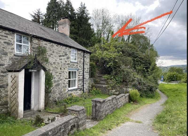
The monument comprises the remains of a motte, dating to the medieval period (c.1066-1540 AD). A motte is a large conical or pyramidal mound of soil and/or stone, usually surrounded by either a wet or dry ditch, and surmounted by a tower constructed of timber or stone.
The motte is situated in the garden of Pen y Bont cottage. It is 23m in diameter at the base, between 4 and 4.5m high, and 10m diameter across the top. The north and east sides of the mound are terminated by retaining walls over 1m high, which mark the boundary of the cottage on the east and the pavement on the north.
The north side of the motte has been planted with flowering shrubs and other garden plants; the remaining sides are mainly grass covered, although the remains of a flower bed are visible on the south side. A concrete pad 2.5m by 2m has been laid on the top of the mound. The septic tanks which serve the cottage lie 8m to the south of the base of the motte.
A wooded area west of the motte is thought to be the site of the bailey (one or more embanked enclosures surrounding, or adjacent to the motte). This area is bounded by a stream lying in a gully 2m deep on the west and south sides. The remains of a slight scarp or ditch are visible running in a south westerly direction from the motte, but it turns south before reaching the gully. There are no remains to suggest how the south side of the gully would have been connected to the motte.
The monument is of national importance for its potential to enhance our knowledge of medieval settlement and defence. It retains significant archaeological potential, with a strong probability of the presence of associated archaeological features and deposits. The structures themselves may be expected to contain archaeological information concerning chronology and building techniques.
The scheduled area comprises the remains described and areas around them within which related evidence may be expected to survive.
Source: Cadw
Other nearby scheduled monuments