Approximate Location Map
Large Map »
This site is entirely user-supported. See how you can help.
Latitude: 51.8492 / 51°50'57"N
Longitude: -3.2612 / 3°15'40"W
OS Eastings: 313219
OS Northings: 217485
OS Grid: SO132174
Mapcode National: GBR YV.TPPF
Mapcode Global: VH6CF.FS88
Entry Name: Carreg Wen Fawr y Rugos cairn cemetery
Scheduled Date: 18 January 2007
Source: Cadw
Source ID: 4282
Cadw Legacy ID: BR354
Schedule Class: Religious, Ritual and Funerary
Category: Cairn cemetery
Period: Prehistoric
County: Powys
Community: Llangynidr
Traditional County: Brecknockshire
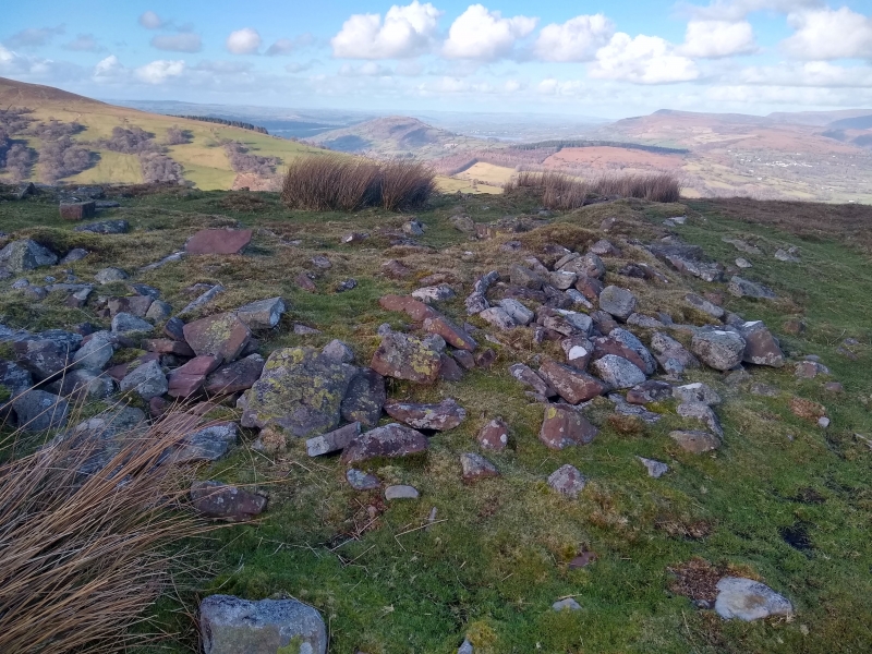
The monument comprises the remains of a prehistoric cairn cemetery, probably dating to the Bronze Age (c.2300 BC - 800 BC). The cemetery contains the remains of at least three round burial cairns, two ring cairns and a stone row and is situated within unenclosed moorland on a terrace on a NE-facing ridge of the Brecon Beacons, above the confluence of the Afon Crawnon and the River Usk. The association of the cairn cemetery with two ceremonial ring cairns and a stone row is unusual and complex. Excavation elsewhere has indicated that ring cairns had a consistent link with the burial of the dead (some cremation burials have been revealed) and rituals involving the burning and deposition of charcoal, perhaps symbolic of the funeral pyre, would seem to have been important. The stone row (Item A) comprises six upright stones aligned from NE to SW and is situated to the NE of the cairn cemetery - clearly associated with the cemetery, the row may have served to guide the eye or the ceremonial procession. An unusual and significant association, the alignment of the row appears to have been obstructed with the deliberate placing of a large recumbent stone across its SW end - perhaps indicating the closure of the cemetery.
The larger ring cairn (Item B) of the two is situated to the WSW of the stone row, on the leading edge of the terrace. It is stone built and is circular on plan, measuring about 12m in overall diameter and up to about 0.4m in height. The central stone built cairn (Item C) is circular on plan and measures about 7m in diameter and up to about 0.3m in height. The smaller ring cairn (Item D) is situated about 90m to the ENE of the central cairn. It comprises a low grass covered ring bank and is apparently undisturbed. It is circular on plan and measures about 9m in overall diameter and up to about 0.1m in height. A further small stone built round cairn (Item E) is situated downslope and immediately to the E of this ring cairn. It measures about 4.5m in diameter and up to about 0.3m in height. The southernmost cairn (Item F) is situated about 70m to the S of the central cairn. It is stone built and is circular on plan, measuring about 8m in diameter and up to about 0.3m in height. Many of the cairns have suffered from disturbance in the past, with probable antiquarian investigation or robbing indicated by central hollows and trenches. Despite this disturbance, the bulk of each cairn remains intact and well-defined and their archaeological potential remains great.
The monument is of national importance for its potential to enhance our knowledge of prehistoric burial and ritual practices. The features are important relics of a prehistoric funerary and ritual landscape and retain significant archaeological potential, with a strong probability of the presence of both intact burial or ritual deposits and environmental and structural evidence. The importance of the monument is further enhanced by the group value formed by the association of the individual cairns within the cemetery - and the topographical association of the cemetery with the many other cairns and cemeteries that can be found within the surrounding area, including the two massive round cairns on Carn Caws (BR355 and BR356).
The scheduled area comprises the remains described and an area around them within which related evidence may be expected to survive. It is circular and measures 400m in diameter.
Source: Cadw
Other nearby scheduled monuments