Approximate Location Map
Large Map »
This site is entirely user-supported. See how you can help.
Latitude: 53.1972 / 53°11'49"N
Longitude: -4.2184 / 4°13'6"W
OS Eastings: 251903
OS Northings: 368975
OS Grid: SH519689
Mapcode National: GBR 5L.2MR1
Mapcode Global: WH546.5WHV
Entry Name: Bryn-yr-Hen-Bobl Burial Chamber
Scheduled Date:
Source: Cadw
Source ID: 3245
Cadw Legacy ID: AN006
Schedule Class: Religious, Ritual and Funerary
Category: Chambered round cairn
Period: Prehistoric
County: Isle of Anglesey (Ynys Môn)
Community: Llanddaniel Fab
Traditional County: Anglesey
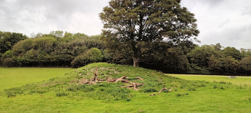
The monument consists of the remains of a chambered round cairn, a Neolithic (4000 to c.2500 BC) or Bronze Age (c.2500 to c.800 BC) burial monument comprising a stone-built chamber within a circular or sub-circular stone-built mound.
The monument consists of a kidney-shaped mound with a megalithic chamber, and a long terrace running off to the south. The open part of the mound, where the entrance to the chamber is, faces towards the east. The mound stands 4-5m in height and is 35m long and 30m wide along an east-west axis. The chamber is constructed of six upright stones, two on either side, one at the end and one blocking the entrance. Internally it measures 2m in length, 1m in width and 1.5m high. The front blocking stone is now broken, but it would appear to have once filled the entrance and to have been pierced by two round holes. The capstone is in two pieces, and overlaps the front blocking stone by 0.6m. A series of dry-stone walls radiate out from the chamber entrance. The dry-stone walling around the chamber entrance is a modern reconstruction. The terrace now appears as a low bank c.10m in width and 0.3m in height, running from the south of the cairn for c.100m in a southerly direction, almost up to the edge of a nearby quarry.
The monument is of national importance for its potential to enhance our knowledge of prehistoric burial and ritual practices. The features are an important relic of a prehistoric funerary and ritual landscape, together with environmental and structural evidence. Chambered round cairns may be part of a larger cluster of monuments and their importance can further enhanced by their group value.
The scheduled area comprises the remains described and areas around them.
Source: Cadw
Other nearby scheduled monuments