Approximate Location Map
Large Map »
This site is entirely user-supported. See how you can help.
Latitude: 52.8982 / 52°53'53"N
Longitude: -4.0113 / 4°0'40"W
OS Eastings: 264802
OS Northings: 335316
OS Grid: SH648353
Mapcode National: GBR 5V.PJ2L
Mapcode Global: WH55V.CD2Z
Entry Name: Bryn Cader-Faner Round Cairn
Scheduled Date:
Source: Cadw
Source ID: 3214
Cadw Legacy ID: ME061
Schedule Class: Religious, Ritual and Funerary
Category: Round cairn
Period: Prehistoric
County: Gwynedd
Community: Talsarnau
Traditional County: Merionethshire
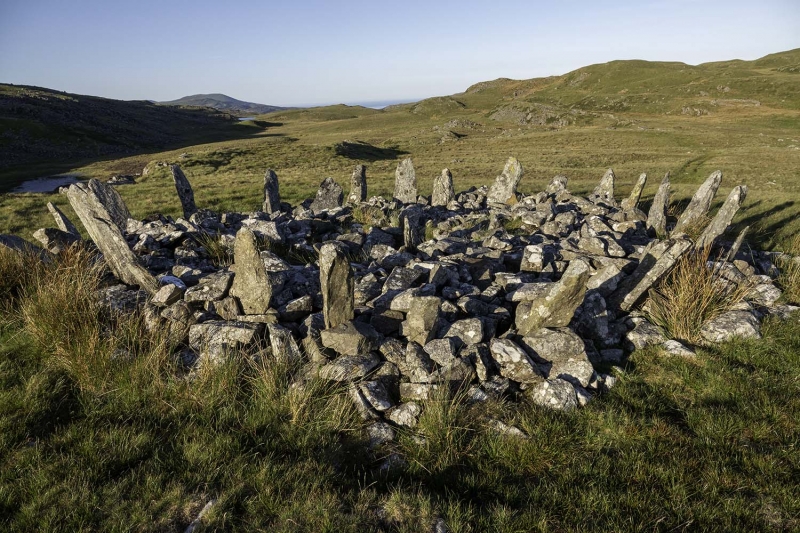
A reasonably well-preserved cairn with a circle of uprights protruding from the cairn at an angle. Some of these are now missing and others at a more marked angle than originally intended, but the silhouette from the SW, from which direction the monument is skylined, is probably not too much different from its original appearance; remarkably, considering the amount of time which has passed since it was built.
The centre, which contained a cist, has been robbed. What is probably one of the missing uprights lies on the lip of the hole, and at least some of the cist slabs are visible within it. Another upright, now almost horizontal, is in its original position but practically buried by the stones of the cairn. With the 18 still more or less upright, only perhaps 6 or 7 are missing, although one of the 18 is apparently a recent addition and not an original stone.
The monument is of national importance for its potential to enhance our knowledge of prehistoric funerary and ritual activities. It retains significant archaeological potential, with a strong probability of the presence of associated archaeological features and deposits.
The scheduled area comprises the remains described and areas around them within which related evidence may be expected to survive.
Source: Cadw
Other nearby scheduled monuments