Approximate Location Map
Large Map »
This site is entirely user-supported. See how you can help.
Latitude: 54.8002 / 54°48'0"N
Longitude: -4.3419 / 4°20'30"W
OS Eastings: 249553
OS Northings: 547550
OS Grid: NX495475
Mapcode National: GBR HJN0.MW9
Mapcode Global: WH3V8.8LNY
Entry Name: Garlieston, Mulberry harbour remains 2070m ENE, 1035m E and 1860m S of
Scheduled Date: 26 April 2011
Last Amended: 12 October 2016
Source: Historic Environment Scotland
Source ID: SM12937
Schedule Class: Cultural
Category: 20th Century Military and Related: Miscellaneous
Location: Sorbie
County: Dumfries and Galloway
Electoral Ward: Mid Galloway and Wigtown West
Traditional County: Wigtownshire
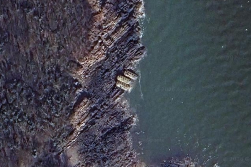
The monument consists of the surviving elements of a Mulberry harbour, a prototype floating artificial harbour, which underwent sea trials near Garlieston in 1943 during the Second World War. The remains comprise seven floating pontoons and a stone and concrete plinth. All seven pontoons lie beached on rocks, with five situated in a small cove known as Port Whapple approximately 2070m east-north-east of Garlieston, and two situated about 1035m east of Garlieston. The stone base is situated on the shore at Rigg Bay, approximately 1860m south of Garlieston and 455m south of Garlieston House.
The seven pontoons, codenamed 'Beetles' during the Second World War, were fabricated from reinforced concrete and originally supported a roadway on a steel superstructure capable of bearing substantial loads. The surviving pontoons are each approximately 15m by 7m and stand approximately 2m in height. The stone plinth relates to a rejected prototype for an alternative harbour design, being used as a tethering point to secure a roadway. It measures about 2.5m by 7.5m and stands about 4m in height.
The area to be scheduled is irregular on plan, to include the remains described above and an area around them within which evidence relating to the monument's construction, use and abandonment may survive, as shown in red on the accompanying map.
Source: Historic Environment Scotland
Cultural Significance
The monument's cultural significance can be expressed as follows:
Intrinsic characteristics
The pontoons belong to a floating harbour prototype designed by the War Office and tested at Garlieston in 1943. Although wrecked on the rocky shore of Eggerness Point during a storm in the 1940s, all seven pontoons survive in good condition. Importantly, all seven 'Beetles' retain a high degree of their original character despite the effects of tidal action and the impact of frequent immersion in seawater.
As a group, the 'Beetles' possess considerable historical interest, as many of their structural characteristics are visible. The internal watertight compartments and the bulkheads separating the compartments are visible through a series of inspection hatches on their upper decks, revealing aspects of their construction and design. Where they have been holed, it is also possible to see how thin the concrete hulls of the 'Beetles' were. As well as the inspection hatches, there are the remains of numerous fixing points for the roadway they were designed to carry. The five pontoons at Port Whapple also retain remains of the wooden 'bumpers', added to protect the sides and bottom of the hulls from being damaged (their bases were liable to being damaged when they rested on the seabed at low tide).
The stone base or plinth overlooking Rigg Bay is a well-built stone construction, dating from about 1942. This formed part of another floating harbour prototype tested at Garlieston, known as the 'Hughes Pier' after its inventor, the Welsh engineer, Iorys Hughes. The base served as a landward tethering point for a tubular steel span roadway carried by large concrete caissons or hulks, known as 'Hippos', that were sunk in position. Part of a 'Hippo' remains visible in Rigg Bay, directly aligned with the stone base.
These remains at Garlieston represent a tangible link to one of the most remarkable feats of military engineering pioneered during World War Two. Together, the pontoons and plinth possess enormous historical significance as the Mulberry harbour project played an integral role in the success of the Allied invasion of Normandy in 1944.
Contextual characteristics
'Mulberry' was the War Office's codename for a project to create artificial harbours. The Mulberry harbour project formed an integral element of the planned invasion of Europe. To support the Allied forces in the weeks following D-Day, it was estimated that up to 18,000 tonnes of supplies per day would need to come ashore in France. However, the major harbours of western Europe had been heavily fortified by the occupying Axis forces and the failed invasion of Dieppe demonstrated that frontal assault on any harbour could only be achieved at an extreme cost in human life and equipment. The only solution was to create a portable harbour in Britain and subsequently transport it to the beachhead. As plans for an invasion of Europe developed in 1942, Prime Minister Winston Churchill issued an order to Lord Mountbatten, Chief of the Imperial Staff, requesting the development of floating piers, capable of rising and falling with the tides, to land soldiers and supplies. Mountbatten overcame the reservations of American military commanders, who doubted the need for the scheme and indeed its effectiveness. At the Quebec conference in October 1942, Mountbatten famously demonstrated the concept behind the Mulberry project to senior military commanders and engineers in his bathroom on board the Queen Mary, using a Mae West lifebelt and a fleet of newspaper boats to show how effective a sheltered harbour was.
In the following months, several concepts were put forward to the War Office. Portable or floating harbours were by no means a novel idea. Churchill himself had mooted such an idea to the Admiralty in 1917 as part of a plan to capture the islands of Borkum and Syllt off the Danish and Dutch coast during World War 1. Drawing on his own experience of the disastrous Gallipoli campaign in 1915, Churchill proposed using a sheltered harbour formed of caissons and blockships to enable an easier landing.
In 1943 three fully functional prototypes, representing the most credible candidates, underwent rigorous sea trials near the fishing village of Garlieston, Dumfries and Galloway. This area was chosen as a testing ground because its topography and tidal range were very similar to the Normandy beaches selected for the D-Day landings in 1944. The schemes tested at Garlieston were the 'Hughes Pier' (designed by Welsh civil engineer Iorys Hughes), the 'Swiss Roll' (designed by the mathematician and inventor Ronald Hamilton) and a design by the War Office's own department, Transportation 5 (Tn5).
The 'Hughes Pier' used a fixed pier and pierhead, a system of concrete caissons able to be towed to position and then sunk. The caissons carried the steel bridge spans known as 'Crocodiles' that ran to the shore. Construction work, undertaken by the firm of Holloway Brothers, progressed at a remote golf course overlooking Conwy Bay as no dry docks were available and this site stretched down to the foreshore. Weighing more than 3,200 tonnes each, the caissons were launched sideways and then floated into Conwy Bay. The stone base at Rigg Bay, Garlieston, formed part of this scheme (although it was not part of the original design), acting as a tethering point. However, the 'Hughes Pier' could not rise and fall with the tide and as a result was rejected as a contender. Despite this, the experience of fabricating the concrete caissons proved useful for future work on the Mulberry project.
Ronald Hamilton's ingenious 'Swiss Roll' design focussed on the concept of a flexible rather than a rigid structure. This design used a floating roadway of planks held together by steel cabling, a concept that relied upon the tension of the steel cables and by Archimedean displacement (namely, that a body immersed in a fluid is subject to an upward force equal in magnitude to the weight of fluid it displaces). As a vehicle drove along it, the roadway would raise hinged sides, preventing water from pouring onto the surface. Designed to attach to a floating jetty, the 'Swiss Roll' was cheap and easy to manufacture. However, as it was unable to bear weights of more than seven tons it could not carry tanks or other heavy vehicles. Even those of lesser weight were forced to drive at slow speed in low gear, frequently causing engines to overheat. These drawbacks effectively ruled out Hamilton's design, although it did play a role in helping infantry reach the shore on D-Day in 1944.
The Tn5 design comprised a pier of steel span bridges (codenamed 'Whales'), supported on anchored pontoons ('Beetles'), and was designed by Major Allan Beckett of the Royal Engineers. The pier attached to a floating pierhead (codenamed 'Spud'), designed by Sir Bruce White, director of Tn5. Supported by four legs, the 'Spud' pierhead could rise and fall on the tide. White drew his inspiration from a dredger and rock-breaking vessel he had seen in the Caribbean that was able to raise and lower itself on adjustable legs. During a storm the captain of the dredger raised his vessel out of the water and secured its legs on the seabed, saving it from being wrecked. Built by the Renfrew firm of Lobnitz and Company, the dredger provided the basis for a pierhead that could rise and fall with the tide, answering the central directive issued by Churchill in May 1942. Lobnitz and Company provided assistance in the production of the pierheads, although their yard was unable to accommodate its fabrication. To allow for torsion, the bridge spans were connected by a new form of socket joint specifically designed for this purpose. Several different designs for pontoons were explored, initially starting with Thames barges, to identify something sufficiently robust to withstand being towed over the English Channel, whilst also being easily and cheaply mass-produced.
A system of breakwaters was devised to protect the pierheads against heavier seas. Three elements were conceived. 'Bombardons' formed the outermost defence, comprising massive ballasted metal crosses designed to be weighted and anchored in place. The backbone of the breakwater system was 146 concrete caissons codenamed 'Phoenixes' (so called because they could rise again), each up to 60m long, 18m high and 15m wide. These created a breakwater some 9.5 km long. Each caisson was effectively an airtight hulk that could be flooded and lowered to the seabed in a controlled manner using air-cocks. Construction of the 'Phoenixes' rested with the War Office and the Royal Engineers, while the 'Bombardons' were built under the authority of the Admiralty and records show that tensions rose over competition for limited manufacturing resources. Supplementing the 'Phoenixes' were about 70 obsolete merchant vessels and warships, that were stripped down, ballasted, and fitted with explosives to sink them in a controlled manner off the beaches of Normandy. Having gathered at Oban, the ships sailed to Normandy under their own steam in June 1944.
Throughout 1944, assembling the various parts in huge numbers for the Mulberry project posed an enormous engineering challenge. Records show that more than 500 firms across Britain worked on fabricating various elements, employing as many as 45,000 men, together with officers and men from the Royal Engineers. Around 300 different firms worked to build the 23 pierheads alone required for the two Mulberry harbours. Fabrication of the 'Phoenixes' presented significant engineering challenges, not least in terms of the enormous volumes of concrete and steel required, but also their sheer size. Much of the fabrication work took place on the Thames or on the River Clyde in existing dockyards or improvised dry docks. 'Phoenixes' were also built on exposed beaches such as Conwy Morfa, a technique learned through the development of Iorys Hughes' 'Hippos'. Building the fleet of 'Phoenixes' brought the strained relationships between various Government departments and branches of the military into sharp focus. Intervention by Churchill and his senior advisers was required to clarify roles and responsibilities. Once completed, the many pieces of the Mulberry harbours were brought to several concentration points along the south coast, with the huge concrete 'Phoenixes' being sunk until needed.
Alongside the process of constructing the Mulberry harbour elements ran the task of training Royal Engineer officers and sappers to build and maintain them when they landed in Normandy. This task fell to a special unit formed by Tn5, named No 1 Transportation Fixed and Floating Equipment, Development and Training Depot RE, which established a training base at Cairnhead on nearby Loch Ryan. An order issued by Bruce White to all Royal Engineer units sought to gather the best engineers the army had to offer for specialist training. Inevitably, many commanding officers used this as an opportunity to offload unpopular officers and many held reputations as troublemakers. The unit also trained sailors from the US Navy Construction Battalions (Seabees), housed at RAF Wigtown. Once training was complete, soldiers moved to one of the assembly units on the south coast of England where they remained until D-Day.
On 4 June 1944, elements of the Mulberry harbours began the slow journey to their assembly point, approximately 5km off the French coast, in anticipation of the D-Day landings on 5 June. As these were delayed by 24 hours, the Mulberry fleet received orders to hold position in the middle of the English Channel. However, by the early hours of 7 June the preparatory work for both the harbours was complete and positioning of the 'Bombardons', blockships and 'Phoenixes' began. Mulberry A was to be constructed at Omaha Beach to supply the American forces in the western half of the area and Mulberry B would be created at Arromanches-les-Bains on Gold Beach to supply the British and Canadians in the eastern half. American forces completed their first piers within five days. However, mistakes made in placing the 'Bombardons' and the arrangement of the pontoons of the 'Whale' bridging spans meant the harbour was probably not as robust as intended. On 18 June an unseasonably violent storm caused many of the 'Bombardons' to break free and smash into the piers of Mulberry A, wrecking it beyond all repair. The same storm caused considerable damage to the British and Canadian piers, although repairs were made using salvaged parts from the American harbour and it continued to function until the end of 1944. After the war, many of the 'Whale' bridging spans were re-used to repair destroyed bridges across France. Several 'Phoenixes' remain visible at Arromanches, while others can still be found along the south coast of England.
Associative characteristics
The Mulberry harbour project involved many institutions, individuals and organisations across Britain and in the United States of America.
Central to the success of the Mulberry project was the support and drive of Winston Churchill. From inception to execution, Churchill frequently sought answers and updates from the War Office on the progress of Mulberry. At various points Churchill is known to have expressed frustration at the (perceived) lack of progress. During World War Two, there were persistent rumours that Churchill paid a secret visit to Garlieston to inspect the Mulberry harbour prototype personally.
Countless engineers contributed to the success of the Mulberry project. Among the most important contributions was that of Sir Bruce White, the head of department Tn5 and ultimately responsible for the planning and delivery of the project. A Royal Engineer during World War 1 and a successful consulting civil engineer during the interwar years (with a particular emphasis on transportation and port engineering), White joined the War Office as a Major in 1941, later rising to the rank of Brigadier, and became head of a newly created Directorate known as Transportation 5 in 1941. With remarkable diplomacy, White successfully negotiated his way through sensitive relations with various Whitehall departments and members of the War Cabinet. In the wake of the storm on 18 June, White personally undertook a visit to provide a first-hand report for Churchill. Following the end of the War, White resumed his career as a consulting engineer, heading his own practice and undertaking commissions from around the world. He received a knighthood for his efforts in 1944.
Allan Beckett also played a central role in the success of the Mulberry project. Beckett was commissioned into the Royal Engineers and assigned to the War Office. In 1942, Beckett was passed a copy of Churchill's directive requesting a workable floating harbour concept. Within a week he had conceived the 'Whale' floating steel span bridges and a prototype model showing how it could cope with torsion. Beckett also invented a new kind of anchor, created especially to secure the floating pontoons. Beckett worked closely with the engineering firm contracted by the War Office to fabricate the 'Whale' spans and the floating pontoons that supported them. During the D-Day landings in June 1944, Beckett travelled to Normandy to oversee the assembly of the Mulberry harbours. For his wartime efforts, Allan Beckett received the MBE and subsequently joined Sir Bruce White's engineering practice, undertaking civil engineering commissions around the world.
Prior to the Second World War, Welsh engineer Iorys Hughes, designer of the 'Hippo' pier system, created the Empire Swimming Pool for the 1924 Empire Games, at what is now known as the Wembley Arena. A keen yachtsman, Hughes' idea for a portable harbour system came to the attention of the War Office thanks to his brother, a serving Royal Navy Lt Commander. Despite his design being rejected by the War Office, Hughes continued to work on the Mulberry project as a consultant.
The third inventor/engineer whose design underwent sea trials at Garlieston was Ronald Hamilton, creator of the 'Swiss Roll' floating roadway. Owing to disability, Hamilton had been unable to serve in the Navy during World War One but, like Beckett and Hughes, he was a keen yachtsman and had volunteered to help in the Dunkirk evacuation. Throughout the war, Hamilton and his wife remained in London living and working in a bomb-damaged wing of the Grosvenor Hotel. Hamilton's 'Swiss Roll' (as it later became known) followed on from another, much more successful floating platform codenamed 'Lily' which was conceived as a solution for landing aircraft at sea. Although recognised as having great potential in the Far Eastern campaign, it never went into production as the American atomic bomb attacks on Hiroshima and Nagasaki brought the conflict against Japan to a swift conclusion.
Garlieston is one of many sites around Britain associated with the development and construction of the Mulberry project. In Scotland, several engineering firms and shipyards contributed to the construction of parts and materials. These included the specialist dredger firm of Lobnitz and Company in Renfrew and Alexander Findlay and Company of Motherwell. Precast concrete was produced at the military pile yard at Old House Point, Loch Ryan, near Stranraer. Engineers undergoing training in assembling pier spans were billeted at Cairnhead, while American naval personnel used RAF Wigtown as accommodation. Remains of a pontoon section are reported off the shoreline of Rubha Dubh on South Uist.
National Importance
This monument is of national importance because it has an inherent potential to make a significant addition to our understanding of the past, in particular the Mulberry harbours deployed during the Normandy landings of June 1944. The visible remains relate to the development and testing of two different concepts and while several sites in Scotland were involved with the construction of the Mulberry harbours, Garlieston was the only place in Britain where extensive sea trials took place. This site is the only place in Scotland where physical remains of the Mulberry harbours survive in good condition and in an accessible location. The loss of the monument would significantly diminish our future ability to appreciate and understand the evolution of the Mulberry harbour concept and Scotland's role in its success. Garlieston is one of a small number of sites in Britain where Mulberry harbour remains still survive. Damage or loss to this site would greatly deplete what is already a rare type of monument.
Source: Historic Environment Scotland
Bibliography
References
Evans J, Palmer E and Walter R (eds), 2000, A Harbour Goes to War, South Machars Historical Society
Hartcup G, 2006, Code Name Mulberry, Pen and Sword Military, Barnsley
Murchie A T, 1999, The Mulberry Harbour Project in Wigtownshire, G C Book Publishers, Wigtown
White, Sir Bruce, nd, The artificial invasion harbours called Mulberry: a personal story by Sir Bruce White KBE,
New Civil Engineer, 1994, 'Mulberry Harbour 1944-1994' in New Civil Engineer 9 June 1994
trove.scot
https://www.trove.scot/place/311532/
https://www.trove.scot/place/311533/
https://www.trove.scot/place/311534/
Source: Historic Environment Scotland
Other nearby scheduled monuments