Approximate Location Map
Large Map »
This site is entirely user-supported. See how you can help.
Latitude: 55.8598 / 55°51'35"N
Longitude: -4.0825 / 4°4'56"W
OS Eastings: 269754
OS Northings: 664917
OS Grid: NS697649
Mapcode National: GBR 3Z.3WLF
Mapcode Global: WH4Q9.8Z66
Entry Name: Monkland Canal, Netherhouse Road to Cuilhill Road
Scheduled Date: 16 December 2013
Source: Historic Environment Scotland
Source ID: SM11334
Schedule Class: Cultural
Category: Industrial: inland water
Location: Old Monkland
County: North Lanarkshire
Electoral Ward: Coatbridge West
Traditional County: Lanarkshire
The monument comprises the remains of part of the Monkland Canal. This section, which is around 1.25km in length, is now mainly culverted and marshy in places. The monument includes the route of the canal, the visible embankments, and the visible and buried sections of the towpath. It also includes the remains of the canal basin and trans-shipment terminal known as the Cuilhill Gullet, including its associated standing masonry walls. This monument is one of five that together constitute the known remains of the Monkland Canal. The canal lies at about 70m OD.
The scheduled area is linear in plan, to include the remains described above and an area around them within which evidence relating to the monument's construction, use and abandonment is expected to survive, as shown in red on the accompanying map. On the S bank, the scheduling runs to the base of the embankment; on the N bank, the scheduling includes the top of the slope of the embankment. Where this feature has been buried, but where the opposite embankment is preserved, the line of the scheduled area has been defined using historic mapping. In the E section, the scheduled area widens up to 125m NNE-SSW (maximum) to include the remains of the Cuilhill Gullet. The scheduling specifically excludes: the M73 motorway bridge; all modern sluices, sluice crossings, drainage features and access hatches; and the above-ground elements of all electricity poles and conduits; water tanks; gas, wastewater and water pipe trenches; fences and gates; modern gardens and garden walls; and the upper 300mm of all access roads, paths and in-filled sections of the canal.
Cultural Significance
The monument's cultural significance can be expressed as follows:
Intrinsic characteristics
The original planned extent of the Monkland Canal was completed in 1794 and it remained in use until the 1930s. It was built to connect the coal-mining areas of Monkland in North Lanarkshire to Glasgow and ran for a total distance of 19.6km (12.25 miles). This section of the canal is in a stable condition and, although now largely culverted, retains its form to a significant degree.
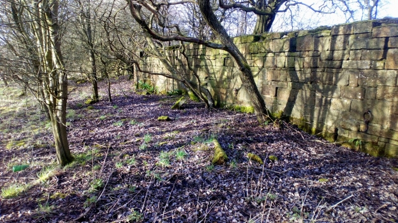
The archaeology of the canal is represented chiefly by the embankments and the navigable channel, even where these have been buried or altered by successive alterations and repairs. Nearly all of the original embankments survive, as do the abutments of the bridges that crossed it from an early date in its use. The Cuilhill Gullet, which lies in the eastern half of this section of the canal, is the remains of an interchange between the Drumpellier Railway and the canal. The railway carried coal from the pits to this point of the canal. From here, around 900 boatloads of coal per year were shipped to Glasgow, which is testament to the success of the canal. The Cuilhill Gullet comprised a railway yard set on an island within a canal basin, elevated by 15m over the surrounding land. The S wall of the railway yard is well-preserved and the original iron mooring-eyes for tying up boats are still visible on its S face. Interchanges of this type are rare survivals across Britain and Ireland, and the Cuilhill Gullet is a unique Scottish survival of a canal/railway interchange in a good state of preservation. The Gullet also testifies to the continuing role of the canal during a period of railway expansion, as it remained in use until 1896.
Contextual characteristics
The Monkland Canal was constructed in the late 18th century, specifically as a means of transporting fuel from the North Lanarkshire coalfields to the rapidly expanding city of Glasgow. Work on the canal began at Sheepford, near Coatbridge, in 1770, and by 1794 its route extended from Calderbank to Port Dundas, Glasgow, to link with the Forth and Clyde Canal. The Monkland Canal has fewer locks and is shorter and narrower than the better-known Scottish canals (the Forth and Clyde, Union and Caledonian Canals).The Monkland Canal had shorter feeder sections to Dundyvan, Langloan, Coatdyke and Gartsherrie, all in or near Coatbridge.
During the 19th century the trade in fuel was supplemented by the addition of iron from the many blast furnaces established adjacent to the Lanarkshire coalfields, and traffic reached a peak in the 1850s and 60s, with over one million tonnes of iron and coal being transported each year. The locations of collieries and ironstone extraction sites are still visible adjacent to the canal, illustrating the relationship between the canal and these formerly significant industries. Eventually, most of the canal's trade was taken over by the network of railways servicing the industrial areas of Lanarkshire and Glasgow. The canal fell out of use by the mid 1930s and was abandoned as a navigable waterway in 1942. Large sections of the waterway have since been filled in, and most of its length through Glasgow now lies beneath the M8 motorway. However, sections of the canal have survived elsewhere, either as water-filled or culverted features, and some parts have been actively maintained as an amenity.
Associative characteristics
The earliest sections of the canal from Sheepford Locks to Blackhill (constructed from 1770 onwards) are the work of the celebrated engineer and inventor, James Watt.
This section of the canal has relatively low amenity value, but the better-preserved sections constitute an important amenity for the communities of Coatbridge and Airdrie today.
Source: Historic Environment Scotland
The monument is of national importance because, as an integral part of the Monkland Canal, it represents an excellent example of Georgian civil engineering. The earliest sections, constructed from 1770 onwards, are the work of the celebrated engineer and inventor, James Watt, and the canal took 24 years to complete. As the main means of transport between the North Lanarkshire coalfields and the rapidly expanding city of Glasgow, the canal epitomises the interdependence of 18th-century Glasgow with the coalfields of North Lanarkshire, which led to the region becoming the most important industrial centre of 19th-century Scotland. The canal itself played a significant role in the development of both coal and ironstone extraction, and facilitated further development of ironworks in the Coatbridge area. The surviving remains of the canal include rare features such as basins, landing stages, possible wharfs and quays. This section is particularly valuable because it represents the remains of a significant length of the canal and includes a railway/canal interchange, which is a rare survival. The loss of the monument would significantly diminish our future ability to appreciate and understand the importance of the Monkland Canal and its contribution to the industrial success of the west of Scotland in the 19th century.
Source: Historic Environment Scotland
Bibliography
RCAHMS records the site as NS66SE 97 and NS66SE 134.
References
Hutton, G 1993, Monkland, the canal that made money, Lanarkshire Heritage Series.
Lindsay, J 1968, The canals of Scotland, Newton Abbot.
Thomson, G, 1945, The Monkland Canal: A sketch of the Early History, Monkland Library Services Department.
Source: Historic Environment Scotland
Other nearby scheduled monuments