Approximate Location Map
Large Map »
This site is entirely user-supported. See how you can help.
Latitude: 55.9996 / 55°59'58"N
Longitude: -3.8073 / 3°48'26"W
OS Eastings: 287381
OS Northings: 679988
OS Grid: NS873799
Mapcode National: GBR 1J.V2LQ
Mapcode Global: WH5QZ.HG6H
Entry Name: Antonine Wall, 170m NNW to 305m NE of Falkirk High School
Scheduled Date: 8 December 2003
Last Amended: 21 June 2013
Source: Historic Environment Scotland
Source ID: SM8828
Schedule Class: Cultural
Category: Roman: Antonine Wall
Location: Falkirk
County: Falkirk
Electoral Ward: Falkirk South
Traditional County: Stirlingshire
The monument comprises a stretch of the Antonine Wall surviving as a particularly well-preserved section of the ditch with buried remains of the outer mound, berm and rampart preserved beneath the topsoil. Approximately 345m in length, this stretch of the Antonine Wall runs from Blinkbonny Road and Westburn Avenue to the north of Falkirk High School, between Westburn Avenue and Anson Avenue, and runs through a gap in housing between Anson Avenue and Frobisher Avenue. The monument was first scheduled in 2003, but an inadequate area was included to protect the full extent of the archaeological remains; the present rescheduling rectifies this.
Dating to the mid- to late second century AD, the Antonine Wall comprised five elements: an outer mound, a broad V-shaped ditch, an open area of ground, the rampart and an associated road known as the military way. In general the Wall ditch was a broad and V-profiled earthwork, measuring approximately 12m in width and around 3.6m in depth with a rectangular slot cut into its base. The outer mound was formed with upcast on the N lip of the ditch that created an additional obstacle and heightened the N slope of the ditch. An open area of ground, known as the berm, separated the ditch from the rampart. The rampart was constructed of turf blocks standing on a stone base around 4.3m in width. From Falkirk to Bo'ness, the rampart was composed of an earth core faced with clay cheeks. Generally, the stone base comprised roughly squared outer kerbs with a rubble core and incorporated culverts, box-like stone-lined channels that allowed water to drain through the rampart more efficiently.
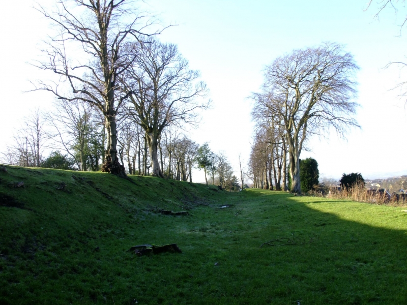
At this site, the Antonine Wall consists of the earthworks of the ditch, while the rampart, berm and the upcast mound survive as buried archaeological deposits, split by Anson Avenue and Westburn Avenue. The longest section lies to the east of Anson Avenue. The preservation of the ditch in all three sections is exceptional considering the extent of development in the immediate area. Although the rampart has been flattened in the westernmost section, it is likely that substantial traces have survived under the topsoil. Originally, this section of the Wall ran through the policies of the former house and gardens of Bantaskin and as a result it was protected from ploughing or other damage until housing construction began in the late 1950s. Western Avenue cut through the line of the Wall in 1976 and excavations in advance of the road construction revealed the stone base of the rampart in well-preserved condition; it had been provided with three culverts to channel water under the rampart base, to ensure its stability and prevent collapse.
The area to be scheduled comprises three separate polygons, each of which is irregular on plan, to include the remains described and an area around them within which related material may be expected to be found, as shown in red on the accompanying map. To allow for their maintenance, the scheduling specifically excludes the topmost 30cm of all paved areas, and it runs up to but does not include property boundaries.
Source: Historic Environment Scotland
Cultural Significance
The monument's cultural significance can be expressed as follows:
Intrinsic characteristics
The monument is a particularly well preserved stretch of the Antonine Wall that has been partially excavated where the ditch retains a significant degree of its profile and depth. Although no longer visible as earthworks, remains of the outer mound, berm and rampart survive beneath the topsoil.
The monument possesses excellent potential to provide high-quality archaeological evidence relating to the date, construction, maintenance and subsequent abandonment of the Antonine Wall and Roman frontier systems in general. There is good potential for the recovery of environmental samples from the fills of the ditch and from ancient ground surfaces sealed beneath the rampart that can improve our knowledge of the local landscape when the Antonine Wall was built and in use.
Contextual characteristics
The Antonine Wall, established in the early 140s AD, represents Scotland's most significant Roman antiquity. Measuring 60km in length, the Wall spans the narrow neck of land between Bo'ness on the River Forth and Old Kilpatrick on the River Clyde. Incorporating a continuous system of wall and ditch, the Wall is accompanied at regular intervals by forts and fortlets linked by a road system. Archaeologists believe the layout of the frontier underwent alteration either during or immediately after construction with more forts being added, reducing the distance between garrisons. The Wall is one of only three linear barriers to be found along the 2000km European frontier of the Roman Empire and these are unique to Germany and Britain, the other examples being Hadrian's Wall and the Rhine limes. However, the Antonine Wall is unique in the disposition of its forts at such close intervals and in the use of a turf superstructure on a stone foundation, an adaptation unparalleled elsewhere in the Roman Empire.
Like other Roman frontiers, the Antonine Wall was intended to control and monitor cross-border movement into Roman-controlled territory rather than acting as a fortification to halt massed attack. However, it is likely that the frontier's physical presence in the landscape, a continuous barrier spanning central Scotland, discouraged small-scale local raiding.
The Antonine Wall has a close relationship with the topography of central Scotland. Much of the frontier occupies the southern edge of the valley formed by the Rivers Kelvin and Carron, a position that offered the Antonine Wall wide-ranging views over the Kilsyth Hills, the Campsie Fells and Kilpatrick Hills and meant that it was widely visible in the landscape. The route of the Antonine Wall also has commanding views over natural communication routes.
The Antonine Wall formed part of the wider Roman reoccupation of Scotland. This comprises a web of roads interconnecting the forts and fortlets controlling the area to the south of the Wall. To the north of the frontier a chain of outpost forts linked by a road extended from Camelon on the outskirts of Falkirk to Bertha on the outskirts of Perth.
This stretch of the Roman frontier is marked with an avenue of mature trees, planted by the former owners of the Bantaskin Estate. Forming a local landmark, the trees allow the line of the Antonine Wall to be readily to be picked out at a distance despite the development of the surrounding area.
Associative characteristics
The Antonine Wall was established by the Emperor Antoninus Pius (AD 138-61) after successful campaigning in AD 139-42 by the Governor of Britain, Quintus Lollius Urbicus. It replaced Hadrian's Wall as the Empire's most northerly frontier. The Wall remained in use until it was abandoned, possibly after AD 165 when the Roman army withdrew from Scotland and the frontier line shifted again to Hadrian's Wall. The construction and purpose of the Antonine Wall exemplifies the wider system of military frontier management, termed limes, which stretched over the whole of the Roman Empire.
The Antonine Wall forms an extension to the existing transnational 'Frontiers of the Roman Empire' World Heritage Site that includes the German limes and Hadrian's Wall. UNESCO approved the addition of the Antonine Wall on 7 July 2008.
This stretch of the Antonine Wall appears as visible earthworks of General William Roy's Roman Military Antiquities of North Britain (plate 35) published in 1793, while the line of the frontier is clearly shown running through the Bantaskin estate on Roy's 1747-57 Military Survey of Scotland. The earthworks appear on the 2nd and 3rd editions of the Ordnance Survey 1:2500 map.
National Importance
The monument is of national importance because it has an inherent potential to contribute to our understanding of the past, in particular the Antonine Wall and the character of Roman frontier systems more generally. The monument has high potential to add to our understanding of the dating, construction, maintenance and subsequent abandonment of the Antonine Wall. There is good potential for the recovery of dateable remains and environmental samples from the fills of the ditch that would enhance our understanding of the character of the local landscape when the Antonine Wall was occupied. The well-preserved stretch of the ditch is a rare survival in what is now an otherwise developed area. The loss of the monument would impede our ability to understand the frontier and would erode the overall importance of the Antonine Wall as a single linear monument spanning central Scotland.
Source: Historic Environment Scotland
Bibliography
References
Breeze, D J 2006,The Antonine Wall, Edinburgh: John Donald.
Hanson, W S and Maxwell, G S 1986, The Antonine Wall: Rome's North West Frontier, Edinburgh: Edinburgh University Press.
Macdonald, G 1934, The Roman Wall in Scotland (2nd Ed), 180, Oxford: Clarendon Press.
Keppie, L J F 1990, Scotland's Roman Remains, Edinburgh: John Donald.
Historic Environment Scotland Properties
Antonine Wall - Bantaskin
https://www.historicenvironment.scot/visit-a-place/places/
Find out more
Source: Historic Environment Scotland
Other nearby scheduled monuments