Approximate Location Map
Large Map »
This site is entirely user-supported. See how you can help.
Latitude: 60.5516 / 60°33'5"N
Longitude: -1.3418 / 1°20'30"W
OS Eastings: 436198
OS Northings: 1185526
OS Grid: HU361855
Mapcode National: GBR R01V.FTR
Mapcode Global: XHD1C.X1WS
Entry Name: Trowie Knowe chambered cairn
Scheduled Date: 20 December 1974
Last Amended: 7 June 2012
Source: Historic Environment Scotland
Source ID: SM3578
Schedule Class: Cultural
Category: Prehistoric ritual and funerary: chambered cairn
Location: Northmaven
County: Shetland Islands
Electoral Ward: Shetland North
Traditional County: Shetland
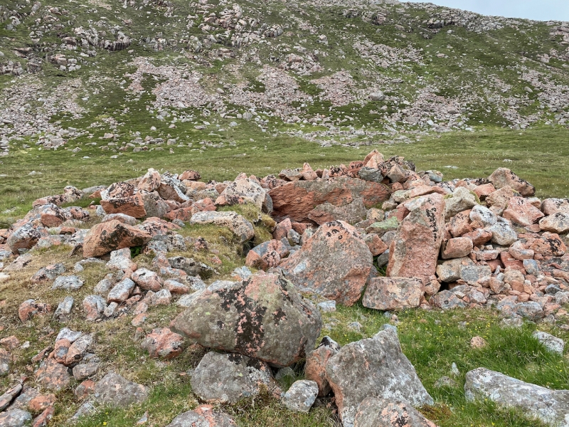
The monument comprises a heel-shaped chambered cairn of the Neolithic period, built probably between 4000 and 2500 BC. It is visible as an upstanding stone-built structure with large facing stones and a largely intact chamber. The cairn measures around 8.6m in diameter and stands between 0.5m and 1.5m high. The cairn has been robbed of material in the past, but the location of the passage is discernible from the layout of the surviving chamber. The chamber is irregular on plan and comprised of two massive blocks of stone that would have supported the now absent capstone. The façade was on the eastern edge of the cairn. A pillar-like stone at its S corner marked the end of what would have been an impressive concave façade. The cairn stands 30m above sea level on a gentle slope at the base of the steep-sided slope of the Beorgs of Housetter and overlooks the Loch of Housetter 100m to the east. The monument was first scheduled in 1974, but the documentation does not meet modern standards: the present rescheduling rectifies this.
The area to be scheduled is a circle, 25m in diameter, centred on the monument. The scheduling includes the remains described above and an area around them within which evidence relating to the monument's construction, use and abandonment may survive, as shown in red on the accompanying map.
Source: Historic Environment Scotland
Cultural Significance
The monument's cultural significance can be expressed as follows:
Intrinsic characteristics
The monument is in a stable condition and retains its form to a significant degree. The cairn has been robbed in the past and partly excavated at least three times, most recently in 1904. The western side of the monument is well defined by facing stones, while the eastern half of the monument has been more heavily robbed. However, there is still a large amount of stone on site and the original cairn would have been very substantial. The remaining spread of stones gives the cairn a circular appearance. The monument preserves several interesting features, including the irregular burial chamber. Despite the removal of stone from this cairn, significant archaeological information is likely to survive beneath its surface, including evidence for its development sequence. During excavation, the chamber was found to contain charcoal deposits and the floor of the chamber was paved with stone, which was not removed.
Chambered cairns are Neolithic in origin, dating most commonly from the third and fourth millennia BC. Excavation elsewhere suggests that they were used over a lengthy period and housed the remains of multiple individuals. Such cairns were often adapted over time and could also form a focus for burial in later periods. Buried deposits associated with cairns can help us to understand more about the practice and significance of burial and commemorating the dead at specific periods in prehistory. They may also help us to understand the changing structure of society in the area. In addition, the cairn is likely to overlie and seal a buried ground surface that could provide evidence of the immediate environment before the monument was constructed. Botanical remains, including pollen or charred plant material, may survive within archaeological deposits deriving from the cairn's construction and use. This evidence can help us to build up a picture of climate, vegetation and agriculture in the area before and during construction and use of the cairn.
Contextual characteristics
Heel-shaped cairns are a rare and distinctive form of chambered cairn found in the Shetland Islands. Heel-shaped cairns share several similar traits with prehistoric houses in Shetland, especially their elaborate well-built façades. The large prehistoric house at Stanydale, which is often referred to as a 'temple', has a similar heel-shaped façade. Heel-shaped cairns are believed to be a variation of the 'Orkney Cromarty' cairn type, as identified by Henshall, but their size is typically much smaller.
This example also has particular interest because of its location in a landscape rich in prehistoric monuments, including other cairns. There are other cairns 75m to the SSW and 180m to the SW. Across Scotland, cairns are commonly positioned to be highly visible and are often inter-visible. The position and significance of this cairn in relation to the two other cairns nearby is likely to be significant and merits future detailed analysis. Given the many prehistoric sites in the area, this monument has the potential to further our understanding not only of funerary site location and practice, but also of the structure of early prehistoric society and economy.
Associative characteristics
The site was partly excavated in 1904 by John Abercromby, an eminent archaeologist of the period. The name 'Trowie Knowe', which means troll or fairy mound, implies that the cairn was a focus of local superstition.
National Importance
This monument is of national importance because it has an inherent potential to make a significant addition to our understanding of the past, particularly the design and construction of burial monuments, the nature of burial practices, and their significance in prehistoric and later society. Buried evidence from cairns can also enhance our knowledge about wider prehistoric society, how people lived, where they came from and who they had contact with. This monument is particularly valuable because it lies in a landscape where there is a wealth of prehistoric monuments. The loss of the monument would significantly diminish our future ability to appreciate and understand the placing of such monuments within the landscape and the meaning and importance of death and burial in prehistoric times.
Source: Historic Environment Scotland
Bibliography
RCAHMS records the site as HU38NE 1.
References
Abercromby, J, 1905 'Report on excavations at Fethaland and Trowie Knowe, Shetland; and of the exploration of a cairn on Dumglow, one of the Cleish Hills, Kinross-shire', Proc Soc Antiq Scot, 39, 171-184.
Calder, C.S.T, 1965 'Cairns, Neolithic Houses and Burnt Mounds in Shetland', Proc Soc Antiq Scot, 96, 45-7.
Henshall, A S, 1963 The Chambered Tombs of Scotland, vol 1. Edinburgh.
Source: Historic Environment Scotland
Other nearby scheduled monuments