Approximate Location Map
Large Map »
This site is entirely user-supported. See how you can help.
Latitude: 55.6305 / 55°37'49"N
Longitude: -2.848 / 2°50'52"W
OS Eastings: 346703
OS Northings: 637760
OS Grid: NT467377
Mapcode National: GBR 83KB.6G
Mapcode Global: WH7WG.7Q1Z
Entry Name: Torwoodlee Tower
Scheduled Date: 28 February 2000
Source: Historic Environment Scotland
Source ID: SM8687
Schedule Class: Cultural
Category: Secular: tower
Location: Caddonfoot
County: Scottish Borders
Electoral Ward: Tweeddale East
Traditional County: Selkirkshire
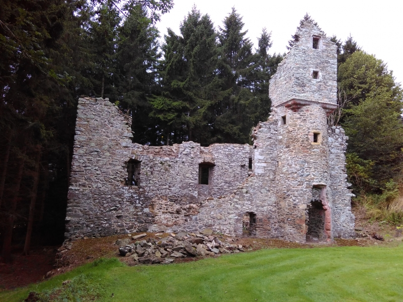
The monument consists of the remains of Torwoodlee Tower, which was built by George Pringle in 1601 replacing an earlier tower, and fell out of use in the late 18th century when the present Torwoodlee House was built.
The tower or mansion is built of whinstone rubble with freestone dressings, and is situated on a steep slope that has been has been extensively terraced to receive the building, its offices and a walled garden to the W. The site is approached from the E via a wide straight path described as the 'Old Avenue'.
The tower makes up the N and W sides of a courtyard. The N side was originally a range of vaulted cellars, now extremely fragmentary, built into the hillside and supporting a terrace. The W range is more complete although the whole N end has been destroyed; while to the S the E wall only survives to first floor level. It consisted of a series of vaulted cellars, including a kitchen to the N, a first floor, which contained the principal rooms, and a second floor attic lit by dormer windows.
Midway along the E facade of the W range projects a tower, semicircular on plan up to the wallhead, where it is corbelled out to the square: the uppermost member of the corbelling is enriched with a continuous band of dog-tooth ornament. The W range was accessed through a doorway in the ground floor of the tower. This led to the cellarage and a scale-and-platt stair, which rose to the first floor. The upper floors were reached by a turnpike stair in the tower.
To the S of the site a retaining wall, rising at the back of a second and lower terrace, runs in alignment with the S gable of the house and carried a low, loopholed parapet which no longer exists. On its W side the tower overlooks a sloping, walled enclosure that has been a garden; there is a built-up doorway in its W wall.
The area to be scheduled includes the towerhouse, its courtyard, terraces and walled garden, and a surrounding area, which has the potential for associated archaeology. The area to be scheduled is roughly rectangular and has dimensions of 104m from its westernmost to its easternmost points and 98m from its northernmost to its southernmost points as marked in red on the attached map.
Source: Historic Environment Scotland
The monument is of national importance as the remains of an early 17th century towerhouse, which demonstrates the changing nature of polite architecture during this transitional period.
The terracing and the garden are rare survivals of the landscape features that would have surrounded many towers. The archaeology of this monument has the potential to contribute to our knowledge of the construction techniques, defences, domestic life and function of such monuments.
Source: Historic Environment Scotland
Bibliography
RCAHMS records the monument as NT 43 NE 49.
Bibliography:
MacGibbon, D. and Ross, T. (1887-92) The castellated and domestic architecture of Scotland from the twelfth to the eighteenth centuries, 5v, Edinburgh, Vol. 4, 209-210.
RCAHMS (1957) The Royal Commission on the Ancient and Historical Monuments of Scotland. An inventory of the ancient and historical monuments of Selkirkshire with the fifteenth report of the Commission, Edinburgh, 38-40, No. 18.
Source: Historic Environment Scotland
Other nearby scheduled monuments