Approximate Location Map
Large Map »
This site is entirely user-supported. See how you can help.
Latitude: 57.3601 / 57°21'36"N
Longitude: -6.4255 / 6°25'31"W
OS Eastings: 133963
OS Northings: 838615
OS Grid: NG339386
Mapcode National: GBR B9J8.FLZ
Mapcode Global: WGY76.88HJ
Entry Name: Dun Beag, broch and surrounding structures, Struan, Skye
Scheduled Date: 31 January 1960
Last Amended: 3 July 2000
Source: Historic Environment Scotland
Source ID: SM90325
Schedule Class: Cultural
Category: Prehistoric domestic and defensive: broch; Secular: farmstead
Location: Bracadale
County: Highland
Electoral Ward: Eilean á Chèo
Traditional County: Inverness-shire
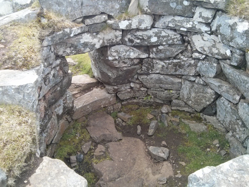
The monument comprises the Iron Age broch of Dun Beag, which is in state care, and a surrounding complex of remains. The latter include quarry pits and field walls and cairns which may be broadly contemporary with the broch, and remains of houses, outbuildings and fields of later date. This scheduling extends legal protection to the remains around the broch, rather than just the broch itself, which is already protected.
Dun Beag is in most respects a typical broch, still standing over 3m high. It is circular on plan, about 11m internal diameter within walls up to 4.3m thick. Its entrance faces E, and does not have a flanking guard chamber. The lower levels of the interior wall face are pierced by a stone staircase within the thickness of the wall and, opposite, an opening giving access to the hollow interior of the upper wall levels. There is also a small chamber within the lower wall, to the right of the entrance.
The broch is surrounded by a scatter of remains, some of which may be associated with it, while others are clearly later. These include a number of quarry pits into the bedrock, remains of drystone walls defining irregular fields, numerous mounds, platforms and small cairns and the foundations of a number of sub-rectangular dwellings and outbuildings. Traces of ridge and furrow cultivation may be seen in several of the field plots.
The area to be scheduled is rectangular in plan, but missing the SW corner. It measures 135m N-S by 115m E-W, missing a triangular area in the SW which is 35m N-S by 50m E-W. This includes all of the structures and remains described above. The area is shown in red on the accompanying map extract.
Source: Historic Environment Scotland
Bibliography
No Bibliography entries for this designation
Historic Environment Scotland Properties
Dun Beag
https://www.historicenvironment.scot/visit-a-place/places/dun-beag-broch
Find out more
Source: Historic Environment Scotland
Other nearby scheduled monuments