Approximate Location Map
Large Map »
This site is entirely user-supported. See how you can help.
Latitude: 59.5147 / 59°30'52"N
Longitude: -1.6467 / 1°38'48"W
OS Eastings: 420091
OS Northings: 1069911
OS Grid: HZ200699
Mapcode National: GBR Q39L.65X
Mapcode Global: XHBZJ.Y35Q
Entry Name: Kirki Geo, settlement and boat-noosts at cemetery, Fair Isle
Scheduled Date: 23 December 1996
Source: Historic Environment Scotland
Source ID: SM6587
Schedule Class: Cultural
Category: Prehistoric domestic and defensive: settlement
Location: Dunrossness
County: Shetland Islands
Electoral Ward: Shetland South
Traditional County: Shetland
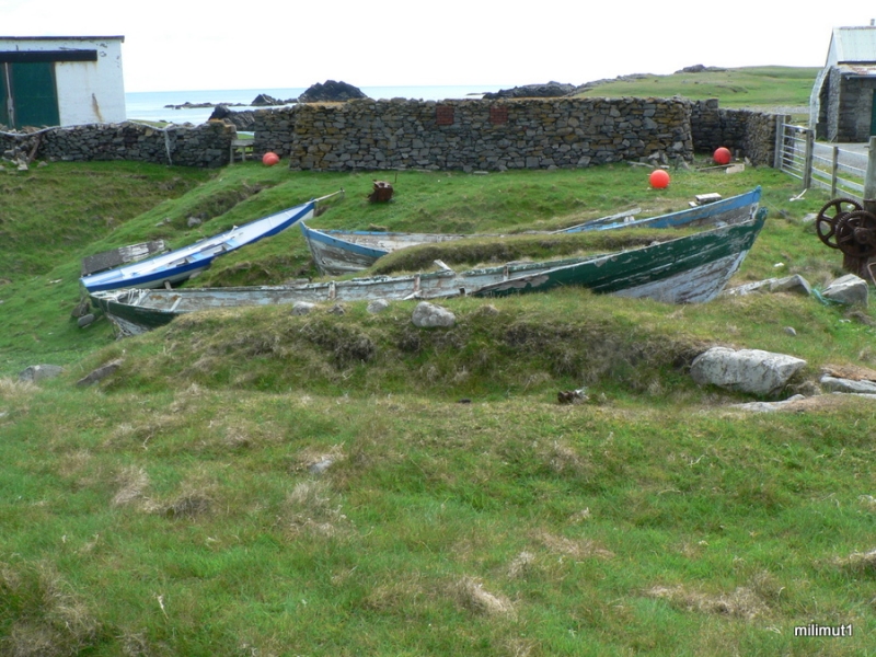
The monument consists of the remains of a settlement of middle to late Iron Age date, situated below and around the graveyard at Kirki Geo, near the S end of Fair Isle, and the remains of several boat-noosts, or shelters.
The settlement is visible on the surface only as a gently-sloping mound with its surface marked by hummocks of indeterminate form. Evidence of archaeological deposits was first noted in the coastal section in 1981-2, and a small trial in 1983 followed by geophysical survey has proved the extent and date of these. The position of the site, underlying the graveyard, may also be significant.
The boat-noosts, at least 14 in number, lie to the S of the settlement, and are a particularly fine group of examples of the type, with both high-level (winter) and low-level (summer) noosts. Although still partly in use, they are undoubtedly the successors, on the same site, to a long series of such simple constructions.
The area to be scheduled is irregular on plan, bounded by the edge of the low cliffs to the SE and by the edge of roadways to the W and N. It excludes the top 2m of soil in the area of the graveyard and also the graveyard's surrounding wall, and also excludes the above-ground portion of all modern fences. The area has maximum dimensions of 120m NNE-SSW by 85m, as marked in red on the accompanying map extract.
Source: Historic Environment Scotland
The monument is of national importance as a site which has proven archaeological deposits with unusually rich pottery and environmental material dating to the period of the construction of brochs or slightly later. Its importance is enhanced by the position of Fair Isle as a mid-way point between Orkney and Shetland. It is likely that the most significant Iron Age settlement on the island would have lain within a few metres of the exposed coastal section, and significant structural remains may still survive.
Source: Historic Environment Scotland
Bibliography
RCAHMS records the monument as HZ 26 NW 1.
Source: Historic Environment Scotland
Other nearby scheduled monuments