Approximate Location Map
Large Map »
This site is entirely user-supported. See how you can help.
Latitude: 60.4262 / 60°25'34"N
Longitude: -1.4144 / 1°24'51"W
OS Eastings: 432345
OS Northings: 1171517
OS Grid: HU323715
Mapcode National: GBR Q1V5.QMJ
Mapcode Global: XHD1X.Z6GG
Entry Name: Punds Water,house and enclosure to W of,Mangaster
Scheduled Date: 20 December 1974
Last Amended: 17 February 1993
Source: Historic Environment Scotland
Source ID: SM3577
Schedule Class: Cultural
Category: Prehistoric domestic and defensive: enclosure (domestic or defensive)
Location: Northmaven
County: Shetland Islands
Electoral Ward: Shetland North
Traditional County: Shetland
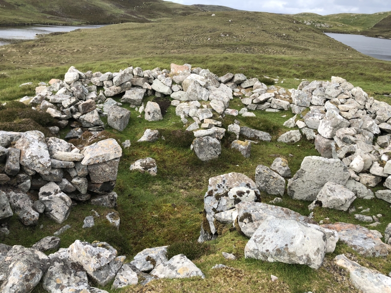
The monument consists of the remains of a prehistoric house and an associated enclosure wall, cutting off a promontory on the W side of Punds Water.
The house is very substantially constructed, and measures about 11m in overall diameter. Internally it has a central area flanked by 4 large and 1 small recesses, possibly bed-niches. Entrance is by a narrow passage, which opens from a paved external courtyard. The careful construction of the house, and the plan (especially its concave facade) suggests a link with the architecture of chambered burial cairns, especially the fine example nearby. The house lies 40m outside an enclosure, formed by a wall of large boulders which cuts off a promontory projecting into the loch. As both the house and the enclosure wall are founded below the deep peat which covers the area, they may be broadly contemporary. The site is most probably a late Neolithic farmstead, with the enclosure serving to enfold stock.
The area to be scheduled is the entire promontory, bounded by the loch and by a curving line drawn between the heads of the loch's two SW inlets and passing 30m to the W of the house. The large area so defined includes the house and enclosure wall and an area of land in which deep peat almost certainly conceals further evidence of contemporary structures. The area to be scheduled is marked in red on the accompanying map.
Source: Historic Environment Scotland
The monument is of national importance as a fine example of a prehistoric house and enclosure, but also because the surviving peat cover around the visible remains holds out the prospect of excellent preservation of further remains often associated with such houses. In addition the surfaces sealed below the peat and the house walls will contain important information relating to contemporary land use, while the peat itself affords the possibility of dating the sequence of peat growth and the abandonment of upland settlement in this area.
Source: Historic Environment Scotland
Bibliography
RCAHMS record the monument as HU37SW 4.
Source: Historic Environment Scotland
Other nearby scheduled monuments