Approximate Location Map
Large Map »
This site is entirely user-supported. See how you can help.
Latitude: 60.3989 / 60°23'56"N
Longitude: -1.3967 / 1°23'48"W
OS Eastings: 433346
OS Northings: 1168486
OS Grid: HU333684
Mapcode National: GBR Q1X7.SVW
Mapcode Global: XHD1Y.6WRF
Entry Name: Isleburgh, prehistoric house and enclosures 760m SSW of
Scheduled Date: 28 August 1974
Last Amended: 5 July 2012
Source: Historic Environment Scotland
Source ID: SM3486
Schedule Class: Cultural
Category: Prehistoric domestic and defensive: house
Location: Northmaven
County: Shetland Islands
Electoral Ward: Shetland North
Traditional County: Shetland
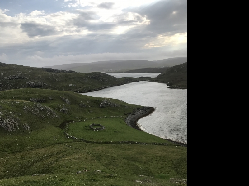
The monument comprises a prehistoric house within an enclosure and an associated field system. The house dates probably from the Neolithic period or Bronze Age, some time between about 4000 and 1500 BC. The house is visible as an upstanding sub-circular feature, formed mainly by turf banks. It measures around 15m N-S by 14m E-W and has an entrance in the south. An annex or yard to the south of the house measures 7m N-S by 11m E-W. A later stone-built plantiecrub overlies the central and southern portion of the house. The house lies within a substantial stone-built semi-circular enclosure that is bounded by the voe to the south. The enclosed area is some 70m NE-SW by 60m NW-SE and includes about 0.3ha of land. The enclosure wall includes some very large stones, up to 1m high, and the overall bank of the enclosure is between 2-3m wide. A prehistoric field lies northwest of the enclosure and is defined by a series of evenly spaced boulders. It is roughly circular in shape, 40m in diameter, and encloses an area of 0.12ha. The monument lies about 5m above sea level on a gentle south-facing slope, just north of the coastline at Holm of Culsetter.
The area to be scheduled is irregular on plan, to include the remains described above and an area around them within which evidence relating to the monument's construction, use and abandonment may survive, as shown in red on the accompanying map.
Source: Historic Environment Scotland
Cultural Significance
The monument's cultural significance can be expressed as follows:
Intrinsic characteristics
The monument survives in reasonably good condition, below closely cropped grass. The sub-circular house is represented on the ground by a stone wall and turf bank around its north side and a turf bank around the south. The house site was partially excavated in the late 1950s. Its northern section and part of the area within the later plantiecrub were excavated to a depth of 0.75m, but the paved stone flooring and a drain were left in situ, suggesting that archaeological evidence is likely to be present even in the excavated areas. A prehistoric trough quern was observed lying on the ground surface next to the house.
Significant buried archaeological remains can be expected to survive beneath and around the visible upstanding structures. The house offers potential for researchers to examine foundations, floor surfaces and associated pits and middens and can improve our understanding of how prehistoric houses were designed, constructed and used. The buried remains may include artefacts and ecofacts that can help us understand how the inhabitants lived, farmed and used the natural environment, and can tell us about the trade and exchange of goods with other groups. Researchers may be able to date the buried remains and determine whether occupation of the site was interrupted by one or more periods of disuse. There is also potential to compare the house building with the field system and the stone enclosure to determine whether all of these features are contemporary, and to ascertain how the inhabitants managed the landscape in the vicinity of the house. There is high potential to determine when and how the field system developed, how it was used and whether the soils were improved.
Contextual characteristics
This monument lies within a landscape that is exceptionally rich in prehistoric archaeological remains and its importance is enhanced because it can be compared with several nearby sites. There is a cairn 125m to the ESE, and two further prehistoric houses, 1.3km to the north and 900m to the south. Across Scotland cairns are commonly positioned to be highly visible and are often inter-visible. The position and significance of this prehistoric settlement and farmland in relation to the cairn is likely to be significant and merits future detailed analysis. Given the many prehistoric sites in the area, this monument has the potential to contribute to our understanding not just of this settlement and its location within the landscape, but also of the structure of early prehistoric society and economy.
National Importance
This monument is of national importance because it has an inherent potential to make a significant addition to our understanding of the past, in particular of prehistoric settlement and land use in Shetland. It has the potential to improve our understanding of the distribution of settlement, the structural techniques used to build houses, changes in the nature of settlement over time, and the relationship between houses and other features, such as field systems and cairns. The loss of the monument would significantly diminish our future ability to appreciate and understand prehistoric settlement and land use in Shetland.
Source: Historic Environment Scotland
Bibliography
RCAHMS records the site as HU36NW 17.
References
Calder, C S T, 1958 'Stone Age house-sites in Shetland', Proc Soc Antiq Scot, 89, 367.
Calder, C.S.T, 1965 'Cairns, Neolithic Houses and Burnt Mounds in Shetland', Proc Soc Antiq Scot, 96, 45-7.
Source: Historic Environment Scotland
Other nearby scheduled monuments