Approximate Location Map
Large Map »
This site is entirely user-supported. See how you can help.
Latitude: 56.64 / 56°38'23"N
Longitude: -3.1594 / 3°9'33"W
OS Eastings: 328988
OS Northings: 750395
OS Grid: NO289503
Mapcode National: GBR VF.0N1V
Mapcode Global: WH6PB.FCRK
Entry Name: Bruceton Farm, symbol stone 410m SSE of
Scheduled Date: 29 November 1923
Last Amended: 19 December 2002
Source: Historic Environment Scotland
Source ID: SM1619
Schedule Class: Cultural
Category: Crosses and carved stones: symbol stone
Location: Alyth
County: Angus
Electoral Ward: Kirriemuir and Dean
Traditional County: Perthshire
The monument comprises a Pictish symbol stone. This symbol stone was first scheduled in 1923, but an inadequate area was included to protect all of the archaeological remains: the present re-scheduling rectifies this.
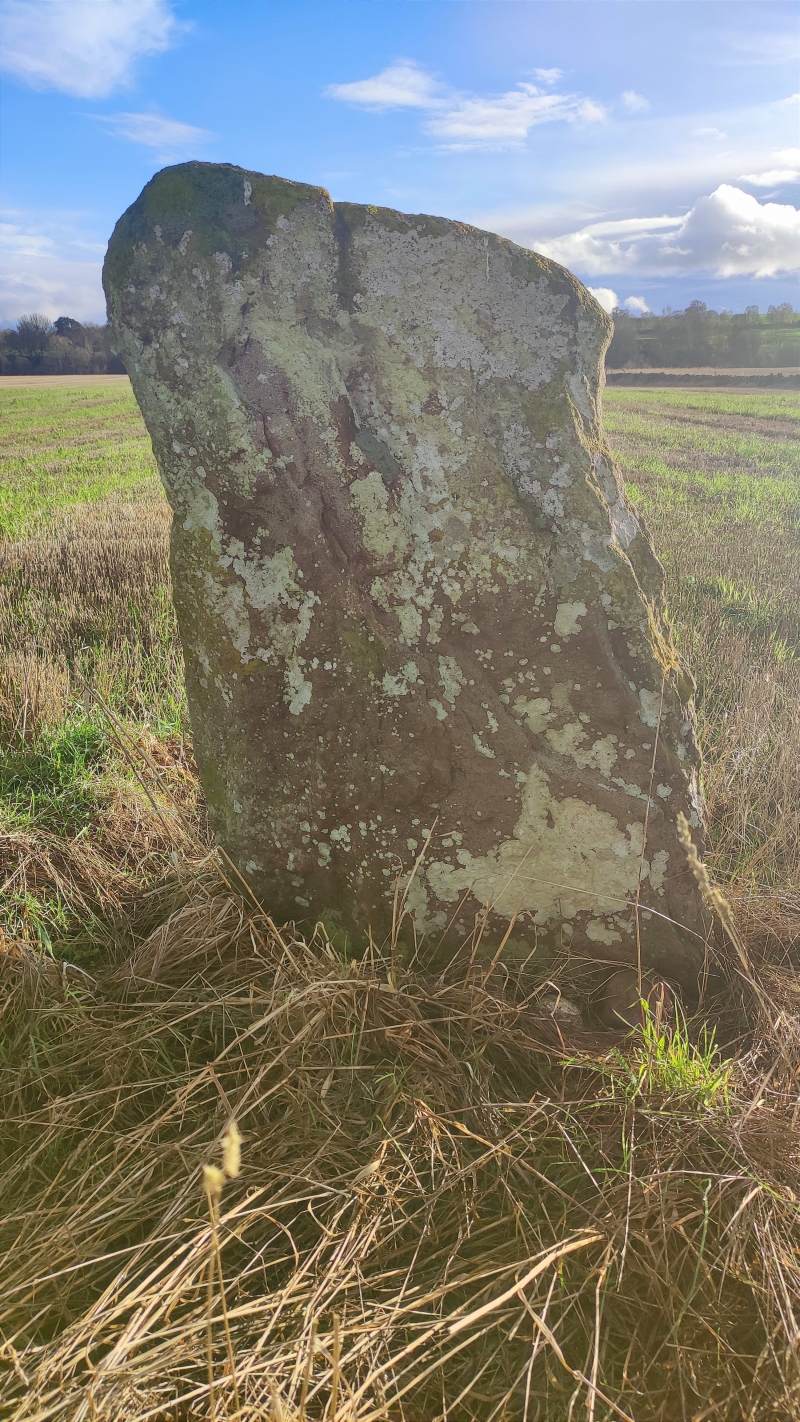
The symbol stone is situated in an arable field, some 410m SSE of Bruceton farm at around 80m OD, on the haughland of the River Isla. The stone stands up to 1.4m high and is 0.25m thick and 0.8m wide. It is of a type known as Class 1 and is inscribed on its S face only, with symbols of an arch and a type of 'Pictish beast' sometimes described as an elephant.
Antiquarian accounts record the discovery of human bones on the haugh and a number of cists less than 18m from the symbol stone.
The area proposed for scheduling comprises the remains described and an area around them within which related material may be expected to survive. It is a circle 10m in diameter, as marked in red on the accompanying map.
Source: Historic Environment Scotland
The monument is of national importance because of its potential to contribute to an understanding of the function and ornament of early medieval carved stones and Pictish burial and ritual practices.
Source: Historic Environment Scotland
Bibliography
RCAHMS record the site as NO25SE 17.
References:
Allen, J. R. and Anderson J. (1903), The early Christian monuments of Scotland: a classified illustrated descriptive list of the monuments with an analysis of their symbolism and ornamentation, Edinburgh, 3, 282-3.
Coutts, H. (1970), Ancient Monuments of Tayside, Dundee, 52, 55, No. 6.
Jackson, A. (1984), The symbol stones of Scotland: a social anthropological resolution to the problem of the Picts, Kirkwall.
Macfarlane, W. (1906-8), Geographical collections relating to Scotland, Mitchell Sir A and Clark J T (eds.), 3v, Edinburgh, Vol. 1, 114.
Meikle, J. (1933), The history of the Alyth parish church, Edinburgh, 16-17.
RCAHMS (1990a), The Royal Commission on the Ancient and Historical Monuments of Scotland, North East Perth: an archaeological landscape, Edinburgh, 87, No. 191.
Ritchie, J. N. G. (1985), Pictish Symbol Stones: a handlist, Edinburgh, 17.
Stuart, J. (1856a), Sculptured stones of Scotland, 1, Aberdeen, 34.
Source: Historic Environment Scotland
Other nearby scheduled monuments