Approximate Location Map
Large Map »
This site is entirely user-supported. See how you can help.
Latitude: 55.2571 / 55°15'25"N
Longitude: -3.4417 / 3°26'30"W
OS Eastings: 308465
OS Northings: 596825
OS Grid: NY084968
Mapcode National: GBR 47DN.P9
Mapcode Global: WH6WZ.34C5
Entry Name: Lochwood Castle, The Mount, Motte and Tower House Complex
Scheduled Date: 1 April 1924
Last Amended: 28 February 2000
Source: Historic Environment Scotland
Source ID: SM698
Schedule Class: Cultural
Category: Secular: castle
Location: Johnstone
County: Dumfries and Galloway
Electoral Ward: Annandale North
Traditional County: Dumfriesshire
The monument consists of a motte-and-bailey castle (commonly called 'the Mount') with a later stone castle situated to the south. The stone castle consists of a large fifteenth century L-planned tower with adjacent courtyard containing ranges of ancillary buildings. The monument was first scheduled in 1924 but the area was inadequate to protect all the remains: the present rescheduling rectifies this.
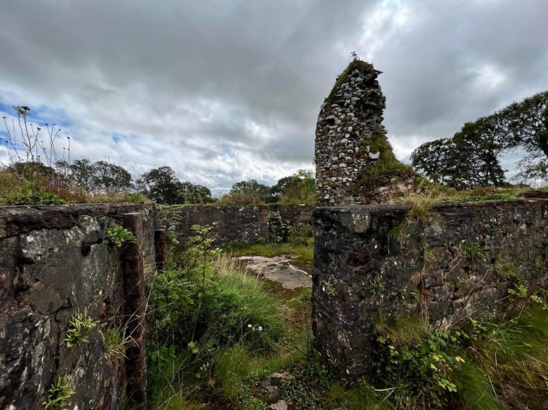
Lochwood Castle was the principal seat of the Johnstone family from the late twelfth century up until the early eighteenth century when the castle was accidentally burned down. In 1547 the castle was described as 'a fair large tower ... with a barmkin hall, kitchen and stables, all within the barnekin'.
The motte-and-bailey castle lies on the E side of a promontory about 600m long and 400 wide which projects northward into Lochwood moss. The motte is situated to the N of the site, just outside the confines of the later stone castle. It has been formed by scarping a natural mound which is up to 12m high on the N and E, and up to 6m high on the S and W, its elongated summit measuring 7m from N to S by 4m transversely. The motte is encircled by two terraces. To the S of the motte lie the remains of the bailey now occupied and obscured by the later stone castle.
The tower is constructed of whinstone rubble with dressed red sandstone surrounds to the windows. The main block measures approximately 11m N-S and 13m E-W, while the jamb projects 3m from the southern half of the N elevation, and measures 5m E-W. The entrance is in the re-entrant angle, and leads directly to a large turnpike, and a mural passage giving access to the basement. In the east wall of this passage a doorway gives access to a second mural passage leading to a prison. The basement is barrel vaulted and is sub-divided into two unequal parts by a cross wall. The first floor is similarly sub-divided, with the larger eastern chamber supplied with a small fireplace and a secondary slop outlet. The tower was extensively consolidated in the 1980s.
The other element of the stone castle consists of two, adjacent, quadrilateral enclosures, with an overall measurement of 46m N-S and 29m E-W. The N enclosure has ranges of buildings built along all but its S wall. The S enclosure has a single range along its N wall, which abuts the jamb of the tower house. At basement level there were two cellars and a kitchen, with a large fireplace, connected by a long trance.
The area to be scheduled includes the motte, the banks and ditches of the bailey, the tower house, its enclosures and ranges, and an area around it, which has the potential for associated archaeology. The area scheduled is irregular in shape and has maximum dimensions of 150m NNW-SSE and 104m from the easternmost to the southwesternmost corners, as marked in red on the attached map. Part of the S and W boundaries of the scheduled area are defined by a modern fence line. The top 50cm of the surface of the roadway within the scheduled area is excluded from the scheduling to enable minor repair and alterations without the need for scheduled monument consent.
Source: Historic Environment Scotland
Bibliography
No Bibliography entries for this designation
Source: Historic Environment Scotland
Other nearby scheduled monuments