Approximate Location Map
Large Map »
This site is entirely user-supported. See how you can help.
Latitude: 55.843 / 55°50'34"N
Longitude: -3.9621 / 3°57'43"W
OS Eastings: 277237
OS Northings: 662833
OS Grid: NS772628
Mapcode National: GBR 00SW.08
Mapcode Global: WH4QK.3DKH
Entry Name: Calderbank Iron Works, furnaces and associated works
Scheduled Date: 29 May 2003
Source: Historic Environment Scotland
Source ID: SM10298
Schedule Class: Cultural
Category: Industrial: iron and steel
Location: Bothwell
County: North Lanarkshire
Electoral Ward: Airdrie South
Traditional County: Lanarkshire
The monument comprises the remains of the iron and steel works at Calderbank, dating from the 1790s to the 1930s.
The monument is situated in the partly overgrown valley to either side of the North Calder Water, to the E of the present-day village of Calderbank.
It consists of the remains of mineral workings, iron and steel making furnaces, forges and mills, engines and turbines, brickworks, wagonways and railways, a railway viaduct, slag heaps, and tunnels and water management systems, visible as upstanding remains, low earthworks, and as buried archaeology.
The industry developed in this area due to the availability of raw materials, namely, coal and blackband ironstone seams, coupled with a good transport system, initially dependent on the W terminus of the Monkland Canal at Woodhall Quay. In its early phase (1790s-1820s), a forge and steel works were operating on site with considerable output. The core of the site consisted of two complexes of puddling furnaces, one on either bank of the river.
On the S side, on the site of the Old Mill, 26 furnaces were constructed c.1839, directly opposite the blast furnaces; another 42 were erected on the opposite bank in 1845, known as the Haugh Mill. In the 1850s the works were connected to the national rail network.
By 1890 the works had converted to steel production employing the Siemens open hearth, latterly supplying large sections of ship plates for the Clyde shipbuilders, including plates for the Queen Mary. The dependency on shipbuilding led to the collapse of the works in 1930 during the great depression.
The site is associated with some of the key individuals responsible for the development and growth of this industry at a national level. These include D. Mushet who realised the potential of the blackband ironstone, and J. B. Neilson who helped develop the hot blast process.
The area proposed for scheduling comprises the remains described and an area around them within which related material may be expected to survive. The area is irregular in plan with maximum dimensions of 720m N-S by 235m W-E, as marked in red on the accompanying map. The paths are included in the scheduling, although the surfaces are excluded to a depth of 300mm.
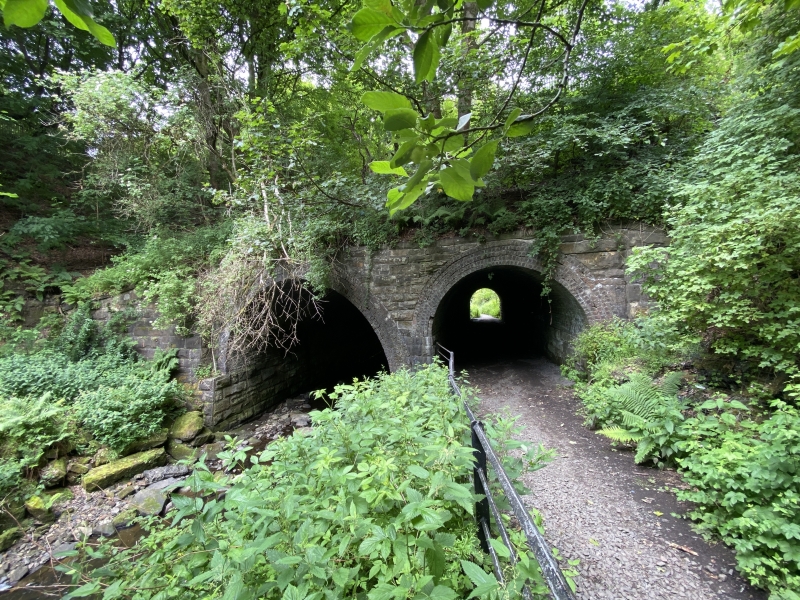
The lower, stone and brick faced section of the tunnel at the S end of the site is included in the scheduling, whereas everything above this, including the modern road, is excluded.
Source: Historic Environment Scotland
The monument is of national importance as the remains of a large iron and steel making complex which contains evidence of practically all phases of the development, installation, growth and demise of this industry in Scotland. Its importance is further increased by the association of the site with some of the key individuals responsible for the development and growth of this industry. Furthermore, Calderbank has the potential to document the technological developments and periods of economic "bust-and-boom" which characterise the industry in the 19th century in Scotland.
Source: Historic Environment Scotland
Bibliography
RCAHMS records the monument as NS76SE 21, 28 and 32.
Aerial Photographs Used:
RCAHMS B62441 Aerial view 1991.
RCAHMS B62442 Aerial view 1991.
References:
SRC SMR (1993) 'Old Monkland parish: Shotts parish', DISCOVERY EXCAV SCOT 1993, 91.
Duncan R undated c. (1984) CALDERBANK: AN INDUSTRIAL AND SOCIAL HISTORY.
Photos-Jones E (1999) THE CALDERBANK PROJECT: A RESEARCH DESIGN. SASAA.
Source: Historic Environment Scotland
Other nearby scheduled monuments