Approximate Location Map
Large Map »
This site is entirely user-supported. See how you can help.
Latitude: 55.9264 / 55°55'35"N
Longitude: -3.6191 / 3°37'8"W
OS Eastings: 298931
OS Northings: 671554
OS Grid: NS989715
Mapcode National: GBR 1R.ZNWQ
Mapcode Global: WH5RG.C9WL
Entry Name: Windywa's Silvermine, silvermine 300m SW of Wester Tartraven
Scheduled Date: 22 February 2005
Source: Historic Environment Scotland
Source ID: SM11226
Schedule Class: Cultural
Category: Industrial: mines, quarries
Location: Torphichen
County: West Lothian
Electoral Ward: Armadale and Blackridge
Traditional County: West Lothian
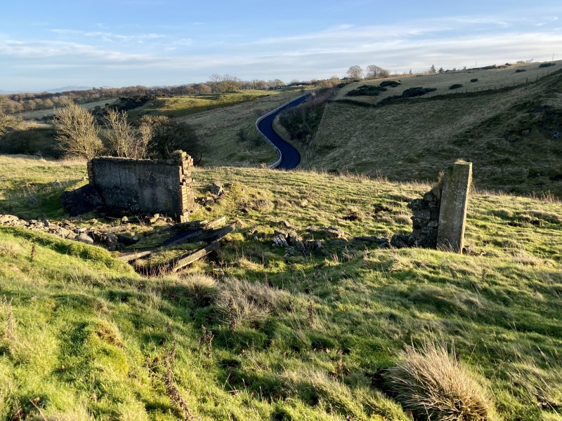
The monument comprises the remains of a silver mine, first worked in the early 17th century with later workings towards the end of the 19th century.
Silver was first discovered at Hilderston in 1606. Sir Thomas Hamilton of Binny and Monkland, the King's Advocate took a lease from James VI in 1607 to work the mine, but it was taken over by the King in 1608, the mine being described then as 'apparently inexhaustible'. At least 7 shafts were opened at this time, with miners being brought from England and Germany to work them. By 1610 the mine was proving less profitable than expected and in 1613 it was let to a private firm and closed soon after 1614. The lease was renewed in 1870 by Mr Henry Aitken of Falkirk, some nickel ore having been recovered from the waste heaps, and in 1873 a deep shaft was sunk, though nothing was found. An old shaft was also cleared, although the project proved unsuccessful and the mine was abandoned in 1898.
The monument is visible as a series of small depressions on the lower SE slopes of Cairnpapple Hill and the upstanding remains of a building associated with the later mine activity. The area to be scheduled is irregular on plan, with maximum dimensions 143m NE-SW by 76m transversely to include the mine shafts, building and an area of ground in which evidence relating to their construction and use may survive. The area is bounded by a road to the E and a stream to the S, as marked in red on the accompanying map.
Source: Historic Environment Scotland
The monument is of national importance as a rare example of an early 17th-century silver mine which has strong links to the Scottish Royal Family and has the potential to greatly enhance our understanding of early mining of precious metals in Scotland.
Source: Historic Environment Scotland
Bibliography
The monument is recorded by RCAHMS as NS97SE34 and NS97SE96.
References:
Aitken H 1894, 'The Hilderston silver mine, near Linlithgow', TRANS FEDERAL INST MINING ENGINEERS 6, 193.
Cadell H M 1925, THE ROCKS OF WEST LOTHIAN, Edinburgh, 359-78.
Udny J 1772, PLAN OF THE SILVER MINES OF HILDERSTOUN AND TARTRAVEN, (copy held in the SRO, HM General Register House, Edinburgh - RHP 6854).
Source: Historic Environment Scotland
Other nearby scheduled monuments