Approximate Location Map
Large Map »
This site is entirely user-supported. See how you can help.
Latitude: 55.9482 / 55°56'53"N
Longitude: -3.1828 / 3°10'58"W
OS Eastings: 326227
OS Northings: 673429
OS Grid: NT262734
Mapcode National: GBR 8QH.S6
Mapcode Global: WH6SM.2RMD
Entry Name: Edinburgh Town Wall, Flodden Wall, Drummond Street to Pleasance
Scheduled Date: 4 December 1970
Last Amended: 4 February 2003
Source: Historic Environment Scotland
Source ID: SM3013
Schedule Class: Cultural
Category: Secular: town wall
Location: Edinburgh
County: City of Edinburgh
Electoral Ward: Southside/Newington
Traditional County: Midlothian
The monument comprises a stretch of the Flodden Wall, one of Edinburgh's late medieval town walls, dating to circa 1513. This stretch runs ENE along Drummond Street, from NT 2613 7338 to NT 2625 7344, where it turns a right-angled corner and then runs NNW along the Pleasance to NT 2621 7352. The monument was originally scheduled in 1970, but there have been a number of developments in its near vicinity since that date. It is being re-scheduled now in order to clarify the extent of the scheduled area, to relate the monument to a modern map and protect it in its modern setting.
The construction of the Flodden Wall is traditionally linked to the fear of English invasion following the defeat of the Scottish army at the Battle of Flodden in 1513. The Wall enclosed areas of the town that had grown outside the limits of earlier town walls, as well as the churches of the Greyfriars, Kirk O' Field and the Blackfriars. Part of the Wall ran along the same line as several ports, which are documented as having been in existence at least eight years before the Battle of Flodden. It is thought likely, therefore, that the threat of invasion gave added impetus to a project already underway to enclose the expanded burgh.
Some sections of the Flodden Wall comprised fortification of an existing wall(s), for example, the strengthening of existing lines of buildings, property boundary dykes, and, possibly, an older town wall. It is documented that work on the Wall was carried out in this manner in several phases until around 1560; as a consequence, the construction method was not consistent.
Documentary evidence testifies that the Flodden Wall had six main ports; that it included towers at strategic points; that it was crenellated; and that the stone used in its rubble construction was quarried locally. The Wall was clearly defensive in intent, but it also defined the legal limit of the medieval burgh in the early 16th century, and would have controlled the passage of people, goods and animals into and out of the burgh, thereby serving to secure the payment of custom dues and prevent the spread of disease.
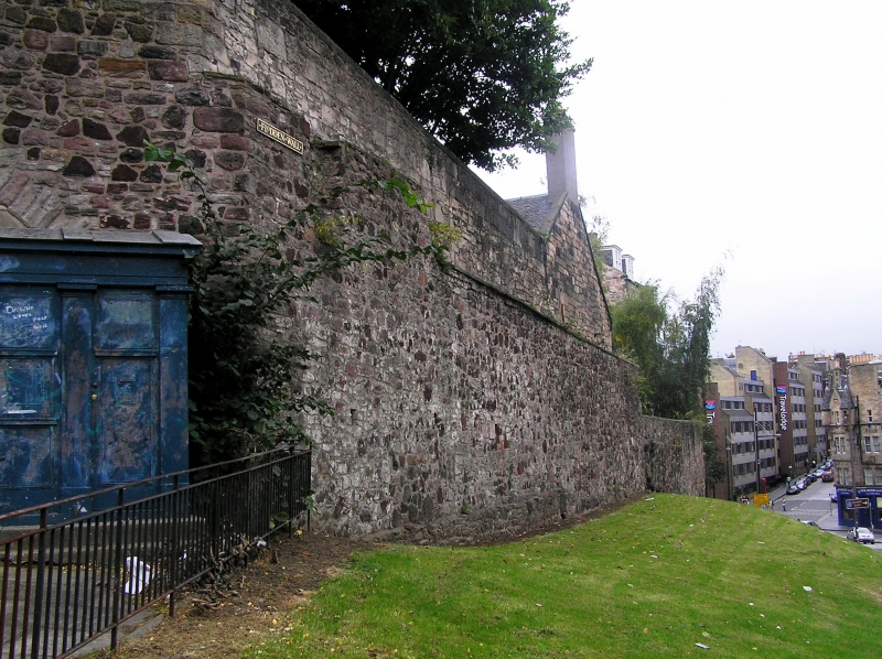
The scheduling comprises a section of the E and S extremities of the Flodden Wall, running along what is now the E half of the N side of Drummond Street and then turning NNW to continue along the W side of Pleasance to the Salvation Army Hostel on the corner of Pleasance and Cowgate. This part of the Wall enclosed the lands of the Blackfriars. The Wall is generally of sandstone in a random rubble construction, with some modern brick infill in the section that runs along Pleasance. It is clearly of different phases, and survives to different heights along the scheduled area.
The westernmost visible part of the Wall lies at NGR NT 2613 7338, about 1.5m below a metal access ramp leading down from Drummond Street, adjacent to the former infant school. After a gap, where there are steps leading down to Infirmary Street, the Wall is visible again adjacent to the boundary wall of the University Buildings, running E along to the University entrance gateway. No remains of the Wall are visible at the gateway, but just to the E of the entrance the Wall is visible again, running down to Pleasance, in a stretch that is much higher and again clearly of different phases. There is a modern metal plaque reading 'Flodden Wall' fixed into the masonry at the E end of Drummond Street.
There was originally a round tower where the Wall turns N at the junction between Drummond Street and Pleasance. The tower was demolished some time ago, and the corner was infilled with a stone wall which includes an archway. The front of the archway has mostly been built up with stone, although there are gaps in the form of a doorway (complete with wooden door) and window (with metal bars across it), and there is a cell inside.
From this corner, the Wall runs N along the W side of Pleasance. This section was consolidated and stabilised in the 1980s, and there are two modern metal 'Flodden Wall' plaques fixed into the W and E ends of this stretch of the Wall respectively. Several phases of construction are visible in this section, and in places the older wall is topped by a more recent wall, probably of 19th-century date. A low modern wall situated a few metres in front of the E end of the Flodden Wall bears a plaque that records the function of the Wall and that conservation works were carried out on the Wall in the late 1980s.
The area to be scheduled is linear in plan and measures a maximum of 230m by 1.3m to include the Flodden Wall, as marked in red on the accompanying map. The metal ramp adjacent to the former school on Drummond Street, the modern wall below the metal ramp, the steps leading from Drummond Street to Infirmary Street, the University entrance gateway from NT 2618 7340 to NT 2620 7341, the modern boundary wall outside the University buildings, the pavement and all upstanding buildings are specifically excluded from scheduling to allow for their routine maintenance.
Source: Historic Environment Scotland
Bibliography
No Bibliography entries for this designation
Source: Historic Environment Scotland
Other nearby scheduled monuments