Approximate Location Map
Large Map »
This site is entirely user-supported. See how you can help.
Latitude: 52.3084 / 52°18'30"N
Longitude: -0.0458 / 0°2'44"W
OS Eastings: 533326.774597
OS Northings: 269609.435
OS Grid: TL333696
Mapcode National: GBR K4L.77Z
Mapcode Global: VHGM5.574P
Entry Name: Low Hill bowl barrow, 575m north of Fen Drayton Reservoir
Scheduled Date: 11 February 2002
Source: Historic England
Source ID: 1020392
English Heritage Legacy ID: 33368
County: Cambridgeshire
Civil Parish: Fen Drayton
Built-Up Area: Fen Drayton
Traditional County: Cambridgeshire
Lieutenancy Area (Ceremonial County): Cambridgeshire
Church of England Parish: Fen Drayton St Mary the Virgin
Church of England Diocese: Ely
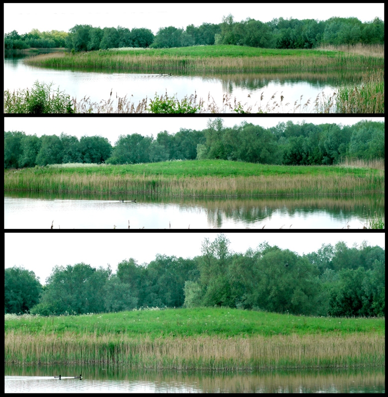
The monument includes Low Hill bowl barrow, situated 575m north of Fen Drayton
Reservoir. It is positioned on the edge of the alluvial terraces of the
prehistoric River Great Ouse, where it once emptied into the Fen. This
location with its mixture of wetter and drier grounds is known to have
attracted occupation from the Early Neolithic period onwards. It is situated
between an important Roman road and a navigable river and it has been
suggested that the barrow is of Roman origin. Its low rounded shape, rather
than the distinctive Roman conical form, however, points to a Bronze Age date.
The mound of Low Hill barrow, preserved as a prominent earthwork, stands 1m
high and covers an area approximately 30m in diameter. Its ditch, from which
earth was dug in the construction of the mound, has become infilled and is no
longer visible above ground. It will, however, survive as a buried feature,
which by comparison with examples excavated elsewhere in the region is
considered to measure approximately 5m wide.
MAP EXTRACT
The site of the monument is shown on the attached map extract.
It includes a 2 metre boundary around the archaeological features,
considered to be essential for the monument's support and preservation.
Source: Historic England
Bowl barrows, the most numerous form of round barrow, are funerary monuments
dating from the Late Neolithic period to the Late Bronze Age, with most
examples belonging to the period 2400-1500 BC. They were constructed as
earthen or rubble mounds, sometimes ditched, which covered single or multiple
burials. They occur either in isolation or grouped as cemeteries and often
acted as a focus for burials in later periods. Often superficially similar,
although differing widely in size, they exhibit regional variations in form
and a diversity of burial practices. There are over 10,000 surviving bowl
barrows recorded nationally (many more have already been destroyed), occurring
across most of lowland Britain. Often occupying prominent locations, they are
a major historic element in the modern landscape and their considerable
variation of form and longevity as a monument type provide important
information on the diversity of beliefs and social organisations amongst early
prehistoric communities. They are particularly representative of their period
and a substantial proportion of surviving examples are considered worthy of
protection.
Low Hill bowl barrow, 575m north of Fen Drayton Reservoir, which has been
mainly under pasture and has not been damaged by intensive cultivation, is an
exceptionally well-preserved and prominent earthwork. It appears to be
undisturbed and will contain a wealth of archaeological evidence relating to
its construction, the manner and duration of its use and other activity on the
site. The monument has additional value as part of an important archaeological
landscape which contains settlement evidence from the Early Neolithic period
onwards.
Source: Historic England
Other nearby scheduled monuments