Approximate Location Map
Large Map »
This site is entirely user-supported. See how you can help.
Latitude: 54.2278 / 54°13'39"N
Longitude: -1.1055 / 1°6'19"W
OS Eastings: 458408.148018
OS Northings: 481707.873374
OS Grid: SE584817
Mapcode National: GBR NMQK.G7
Mapcode Global: WHD8L.ZZQT
Entry Name: Linear dyke known as Double Dikes, in Waterloo Plantation
Scheduled Date: 22 January 1969
Last Amended: 6 October 2000
Source: Historic England
Source ID: 1019346
English Heritage Legacy ID: 32675
County: North Yorkshire
Civil Parish: Sproxton
Traditional County: Yorkshire
Lieutenancy Area (Ceremonial County): North Yorkshire
Church of England Parish: Helmsley All Saints
Church of England Diocese: York
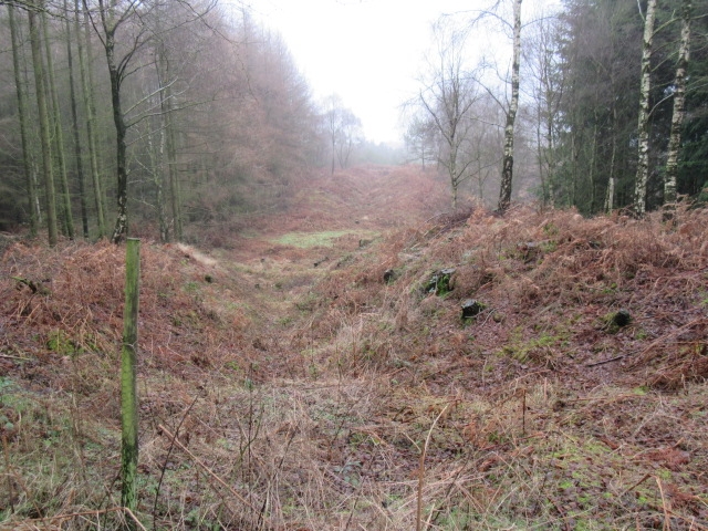
The monument includes earthwork and associated buried remains of a 340m long
section of a prehistoric boundary dyke known as Double Dikes. The section
which forms the monument runs north-south through Waterloo Plantation, and is
centred 600m north east of Waterloo Farm.
Double Dikes was first recorded by the 1642 Estate Survey for Francis Lord
Villiers of Helmsley where it was labelled Rowland Dykes. It was mapped again
in the 19th century by the Ordnance Survey. Double Dikes originally extended
northwards from the top of Smith Hill Howl, a steep-sided stream gorge on the
hillside above Ampleforth, to join another steep-sided valley known as Stone
Bridge Howl which effectively continues the boundary to the north east to end
at the River Rye. This whole boundary has been interpreted as the south
easternmost component of a complex of dykes known as the Cleave Dyke system.
This extends for about 8km along the top of the scarp of the Hambleton Hills
between 400m south east of the top of Sutton Bank and Steeple Cross boundary
stone on the north side of Dale Town Common. It has also been suggested that
Double Dikes is associated with Studfold Ring which is an enclosure with a
bank and internal ditch dated to the Iron Age which lies 1.8km to the south of
the monument, 300m east of the southern end of the dyke close to Smith Hill
Howl. Another possible association is with the three round barrows, thought to
be Bronze Age, 300m beyond the north end of the dyke on Far Moor.
The section of Double Dikes which forms the monument extends from Stone Bridge
Howl southwards to a forest track just north of Cote Lane, the A170. Between
the track and the road the dyke has been removed by quarrying and to the south
of the road, the dyke has been levelled by agriculture. The southern part of
Double Dikes, which partly lies within Pry Rigg Plantation, also survives as
an earthwork and this is the subject of a separate scheduling.
Within Waterloo Plantation, Double Dikes is formed by a ditch with flanking
banks, with the western bank typically being slightly higher and broader than
the eastern. The banks are typically 0.5m to 1m high and 4m-5m wide with their
tops being 7m-8m apart. There are no berms between the base of the banks and
the top of the ditch, instead the profile is continuous, with the base of the
ditch being typically 2m-2.5m below the top of the banks, although this depth
increases to around 3m in the southern part of the monument. Double Dikes as a
whole is typically 13m-15m wide. Towards the southern end of the monument
there is a 20m wide gap in the dyke at the base of a slight fold in the
hillside which further downhill to the east becomes another steep sided gorge
known as Beech Gill. On the 1:10,000 map this gap is marked by a trackway.
This is considered to be an original causeway through the boundary, and is
very different in nature to the places where two further trackways cut through
the dyke further to the north, where it can be seen that the ditch has been
infilled and the banks cut through. At the north end of the dyke the two banks
fade out, the eastern, downhill side bank continuing the furthest, as the
ditch runs down the increasingly steep slope into Stone Bridge Howl.
All fence posts are excluded from the scheduling, although the ground beneath
these features is included.
MAP EXTRACT
The site of the monument is shown on the attached map extract.
It includes a 2 metre boundary around the archaeological features,
considered to be essential for the monument's support and preservation.
Source: Historic England
The Cleave Dyke system is the most westerly of a series of dyke systems on the
Tabular Hills of north east Yorkshire. The name has been given to a series of
linear ditches and banks stretching north-south over 9km parallel with and
close to the western scarp of the Hambleton Hills. The system was constructed
between the Late Bronze Age and the Iron Age to augment the natural division
of the terrain by river valleys and watersheds. Significant stretches remain
visible as upstanding earthworks; elsewhere it can be recognised as a cropmark
on aerial photographs. The system formed a prehistoric territorial boundary in
an area largely given over to pastoralism; the impressive scale of the
earthworks displays the corporate prestige of their builders. In some
instances the boundaries have remained in use to the present day. Linear
boundaries are of considerable importance for the analysis of settlement and
land use in the later prehistoric period; all well preserved examples will
normally merit statutory protection.
The linear dyke known as Double Dikes, within Waterloo Plantation, is a well
preserved section of prehistoric boundary. Its importance is heightened by its
spatial association with the three round barrows on Far Moor to the north and
to Studfold Ring to the south.
Source: Historic England
Books and journals
Spratt, D A , 'The Archaeological Journal' in The Cleave Dyke System, , Vol. 54, (1982), 33-52
Source: Historic England
Other nearby scheduled monuments