Approximate Location Map
Large Map »
This site is entirely user-supported. See how you can help.
Latitude: 54.9783 / 54°58'41"N
Longitude: -1.7655 / 1°45'55"W
OS Eastings: 415106.864287
OS Northings: 564879.835443
OS Grid: NZ151648
Mapcode National: GBR JB3W.K6
Mapcode Global: WHC3N.V4GD
Entry Name: Motte, 50m north of Holycross Church, Ryton
Scheduled Date: 17 November 1964
Last Amended: 2 December 1998
Source: Historic England
Source ID: 1018677
English Heritage Legacy ID: 32043
County: Gateshead
Electoral Ward/Division: Ryton, Crookhill and Stella
Built-Up Area: Ryton
Traditional County: Durham
Lieutenancy Area (Ceremonial County): Tyne and Wear
Church of England Parish: Ryton
Church of England Diocese: Durham
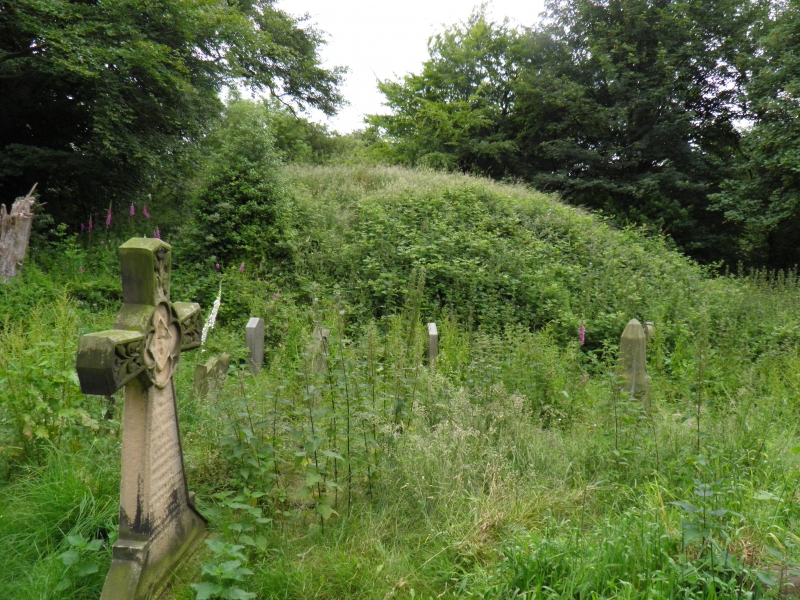
The monument includes a medieval motte mound and associated ditch, occupying
the north end of a spur to the north of Holycross Church, Ryton, commanding a
view over the River Tyne.
The mound is 30m in diameter at its base, 4m high and 9m in diameter at its
top. The top of the mound is triangular in plan with corners on the north,
south east and south west. A 1m wide linear depression running across the top
of the mound may indicate an unrecorded excavation. The ditch curves round the
south side of the motte, cutting across the spur. There is no evidence of a
ditch on the other sides of the mound where the ground falls steeply away. The
ditch is 2m wide at its base, 12m wide at its top and 1.6m below the level of
the ground to the south. The ditch and the foot of the slope of the mound
contain some pre-20th century graves, which are excluded from the scheduling
although the ground beneath them is included.
The relationship between the mound and the steep slope will be preserved to
the west of the mound where there has been no discernible disturbance caused
by the presence of the graveyard.
MAP EXTRACT
The site of the monument is shown on the attached map extract.
It includes a 2 metre boundary around the archaeological features,
considered to be essential for the monument's support and preservation.
Source: Historic England
Motte castles are medieval fortifications introduced into Britain by the
Normans. They comprised a large conical mound of earth or rubble, the motte,
surmounted by a palisade and a stone or timber tower. In a majority of
examples an embanked enclosure containing additional buildings, the bailey,
adjoined the motte. Motte castles and motte-and-bai1ey castles acted as
garrison forts during offensive military operations, as strongholds, and, in
many cases, as aristocratic residences and as centres of local or royal
administration. Built in towns, villages and open countryside, motte castles
generally occupied strategic positions dominating their immediate locality
and, as a result, are the most visually impressive monuments of the early
post-Conquest period surviving in the modern landscape. Over 600 motte castles
and motte-and-bailey castles are recorded nationally, with examples known from
most regions. Some 100-150 examples do not have baileys and are classified as
motte castles. As one of a restricted range of recognised early post-Conquest
monuments, they are particularly important for the study of Norman Britain and
the development of the feudal system. Although many were occupied for only a
short period of time, motte castles continued to be built and occupied from
the 11th to the 13th centuries, after which they were superseded by other
types of castle.
The motte 50m north of Holycross Church is a well preserved example of this
class of monument. The top of the mound and the ditch, where graves have not
disturbed it, will preserve deposits relating to the motte's construction and
use.
Source: Historic England
Other nearby scheduled monuments