Approximate Location Map
Large Map »
This site is entirely user-supported. See how you can help.
Latitude: 54.9767 / 54°58'36"N
Longitude: -1.7641 / 1°45'50"W
OS Eastings: 415196.745226
OS Northings: 564701.613862
OS Grid: NZ151647
Mapcode National: GBR JB3W.WS
Mapcode Global: WHC3N.W54M
Entry Name: Ryton village cross 160m south east of church
Scheduled Date: 30 November 1950
Last Amended: 2 December 1998
Source: Historic England
Source ID: 1018642
English Heritage Legacy ID: 32049
County: Gateshead
Electoral Ward/Division: Ryton, Crookhill and Stella
Built-Up Area: Ryton
Traditional County: Durham
Lieutenancy Area (Ceremonial County): Tyne and Wear
Church of England Parish: Ryton
Church of England Diocese: Durham
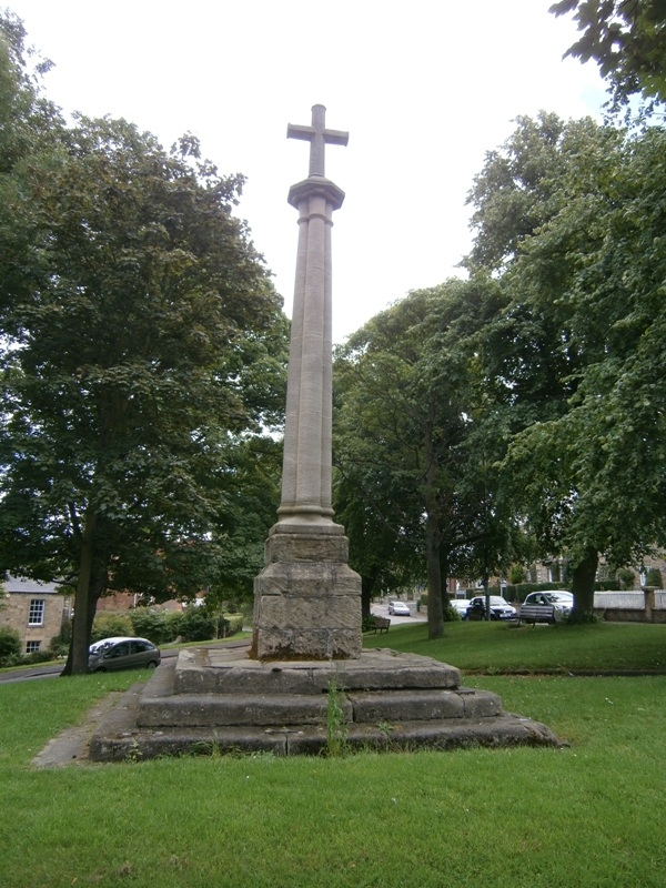
The monument includes Ryton village cross, which is situated on the village
green.
The cross, which is Listed Grade II, is constructed of sandstone and has a
three step base, box, shaft and cross head. The base is 3.9m by 3.9m at ground
level and 2.5m by 2.5m at the top. The steps have been strengthened by the
addition of iron cramps leaded into the steps. The top step stones are worn on
the inner side of their tops and some have been grooved to assist drainage.
The box is 1m by 1m and 1m high. It consists of three courses, each course
containing three 1m long ashlar stones. The courses are laid in alternate
directions. The top course is chamfered. The date stone is 0.72m by 0.72m and
0.25m tall. It has the date `1795' on its north and south face. On the east
and west faces there are inset plaques, the contents of which are not
discernible. The shaft is modern, about 5m tall and surmounted by a modern
1.5m cross with octagonal shaft and arms. The base of the shaft has the date
`1951' on its north and south face.
The cross head replaced in 1951 now stands in the grounds of Tyndale House,
Ryton and is not included in the scheduling. The shaft has not been located.
The cross and shaft are dated to 1795 and were erected by Thomas Chancer, a
well known mason in Ryton. Ryton cross was used for preaching by Charles
Wesley in October 1742 and by John Wesley in June 1757, which confirms the
existence of a cross prior to the erection of Thomas Chancer's 1795 cross. The
cross has been used as the focal point for the Ryton Hirings which were held
twice a year, in May and November.
The kerbed path where it falls within the protection margin of the cross is
excluded from the scheduling, although the ground beneath is included.
MAP EXTRACT
The site of the monument is shown on the attached map extract.
It includes a 2 metre boundary around the archaeological features,
considered to be essential for the monument's support and preservation.
Source: Historic England
A standing cross is a free standing upright structure, usually of stone,
mostly erected during the medieval period (mid 10th to mid 16th centuries AD).
Standing crosses served a variety of functions. In churchyards they served as
stations for outdoor processions, particularly in the observance of Palm
Sunday. Elsewhere, standing crosses were used within settlements as places for
preaching, public proclamation and penance, as well as defining rights of
sanctuary. Standing crosses were also employed to mark boundaries between
parishes, property, or settlements. A few crosses were erected to commemorate
battles. Some crosses were linked to particular saints, whose support and
protection their presence would have helped to invoke. Crosses in market
places may have helped to validate transactions. After the Reformation, some
crosses continued in use as foci for municipal or borough ceremonies, for
example as places for official proclamations and announcements; some were the
scenes of games or recreational activity.
Standing crosses were distributed throughout England and are thought to have
numbered in excess of 12,000. However, their survival since the Reformation
has been variable, being much affected by local conditions, attitudes and
religious sentiment. In particular, many cross-heads were destroyed by
iconoclasts during the 16th and 17th centuries. Less than 2,000 medieval
standing crosses, with or without cross-heads, are now thought to exist. The
oldest and most basic form of standing cross is the monolith, a stone shaft
often set directly in the ground without a base. The most common form is the
stepped cross, in which the shaft is set in a socket stone and raised upon a
flight of steps; this type of cross remained current from the 11th to 12th
centuries until after the Reformation. Where the cross-head survives it may
take a variety of forms, from a lantern-like structure to a crucifix; the more
elaborate examples date from the 15th century. Much less common than stepped
crosses are spire-shaped crosses, often composed of three or four receding
stages with elaborate architectural decoration and/or sculptured figures; the
most famous of these include the Eleanor crosses, erected by Edward I at the
stopping places of the funeral cortege of his wife, who died in 1290. Also
uncommon are the preaching crosses which were built in public places from the
13th century, typically in the cemeteries of religious communities and
cathedrals, market places and wide thoroughfares; they include a stepped base,
buttresses supporting a vaulted canopy, in turn carrying either a shaft and
head or a pinnacled spire. Standing crosses contribute significantly to our
understanding of medieval customs, both secular and religious, and to our
knowledge of medieval parishes and settlement patterns. All crosses which
survive as standing monuments, especially those which stand in or near their
original location, are considered worthy of protection.
Ryton cross is believed to be the site of a cross prior to the 1795 cross of
Thomas Chancer. It is locally important as the focal point of the Ryton
Hirings and is associated with John and Charles Wesley, who preached here in
the eighteenth century.
Source: Historic England
Books and journals
Bourn, W, History of the Parish of Ryton, (1896), 33-35
Rippeth, N G, Ryton in Old Picture Postcards, (1988)
Source: Historic England
Other nearby scheduled monuments