Approximate Location Map
Large Map »
This site is entirely user-supported. See how you can help.
Latitude: 50.3899 / 50°23'23"N
Longitude: -4.7407 / 4°44'26"W
OS Eastings: 205280.258177
OS Northings: 58035.514695
OS Grid: SX052580
Mapcode National: GBR N2.SS2S
Mapcode Global: FRA 08Y0.JYL
Entry Name: St Cyor's well house
Scheduled Date: 23 March 1953
Last Amended: 29 April 1998
Source: Historic England
Source ID: 1018204
English Heritage Legacy ID: 30444
County: Cornwall
Civil Parish: Luxulyan
Built-Up Area: Luxulyan
Traditional County: Cornwall
Lieutenancy Area (Ceremonial County): Cornwall
Church of England Parish: Luxulyan
Church of England Diocese: Truro
The monument includes a medieval holy well house, known as St Cyor's Well (or
St Cyr's), situated in a small cobbled courtyard to the east of the parish
church at Luxulyan.
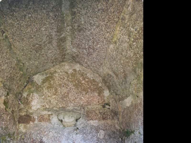
St Cyor's Well survives as a small granite building over a well basin. The
structure measures 1.81m east-west by 2.04m north-south. The building is
constructed of large granite blocks and mortar, the walls are 1.37m high above
ground level and the gabled roof slopes steeply above, giving an overall
height of approximately 3m. The tall, narrow arched entrance faces east and is
decorated with a simple moulding. The interior of the well house measures
1.12m long by 0.96m wide and is 2.05m high. The well basin measures 1.02m long
by 0.74m wide and is 0.20m deep. It has a modern cement floor. In the south
wall is a small rectangular recess probably for placing a jug when
collecting water. On the west wall is a moulded step or platform of Pentewan
stone projecting out of the wall, originally designed to display a figure,
probably of the saint to whom the well was dedicated. Immediately to the east
of the well is a modern recess formed by a low granite wall to either side and
two steps down to the well entrance.
St Cyor's well house is believed to date from the 15th century. Quiller-Couch
visited this well in the mid-19th century and recorded that it was in good
condition and had a constant supply of water. In 1873-4 the stream which
supplied the well was diverted when a cutting was made for a mineral tramway.
By the later 19th century the well was dry and falling into a ruinous state.
In 1891 when M and L Quiller-Couch visited the well it had been carefully
restored but there was a tank in the interior and a tap. Water was piped to
the well from the vicarage. By 1925 the well was again falling into decay. In
1980 the well house was repointed and a cobbled courtyard built around it;
the cement floor was probably put in the well basin at this time.
The modern granite bench to the south of the well house, the wooden troughs
and tubs containing flowering plants and the wooden trellis to either side of
the well house are excluded from the scheduling, although the ground beneath
these features is included.
MAP EXTRACT
The site of the monument is shown on the attached map extract.
Source: Historic England
Holy wells are water sources with specifically Christian associations. The
custom of venerating springs and wells as sacred sites is also known to have
characterised pre-Christian religions in Britain and, although Christian wells
have been identified from as early as the 6th century AD, it is clear that
some holy wells originated as earlier sacred sites. The cult of holy wells
continued throughout the medieval period. Its condemnation at the time of the
Reformation (c.1540) ended new foundations but local reverence and folklore
customs at existing holy wells often continued, in some cases to the present
day.
The holy wells sometimes functioned as sites for baptism but they were also
revered for less tangible reasons, some of which may have had origins in pre-
Christian customs, such as folklore beliefs in the healing powers of the water
and its capacity to effect a desired outcome for future events. Associated
rituals often evolved, usually requiring the donation of an object or coin to
retain the 'sympathy' of the well for the person seeking its benefits.
At their simplest, holy wells may be unelaborated natural springs with
associated religious traditions. Structural additions may include lined well
shafts or conduit heads on springs, often with a tank to gather the water at
the surface. The roofing of walled enclosures to protect the water source and
define the sacred area created well houses which may be simple, unadorned
small structures closely encompassing the water source, or larger buildings,
decorated in the prevailing architectural style and facilitating access with
features such as steps to the water source and open areas with stone benching
where visitors might shelter. At their most elaborate, chapels, and sometimes
churches, may have been built over the well or adjacent well house. The number
of holy wells is not known but estimates suggest at least 600 nationally. They
provide important information on the nature of religious beliefs and practices
and on the relationship between religion and the landscape during the medieval
period.
St Cyor's holy well house survives well, despite having undergone some
restoration in the 19th and 20th centuries. Although the well is dry as the
stream which supplied the water was diverted away from the well in the last
century, the local people still venerate it, leaving gifts of fruit, flowers
and candles in the well house. It is a good example of a holy well having a
basin inside a well chamber, and a well house built over the top.
Source: Historic England
Books and journals
Henderson, C, The Cornish Church Guide, (1928)
Quiller Couch, L, Quiller Couch, M, Ancient and Holy Wells of Cornwall, (1894)
Other
AM 7 scheduling documentation for CO 348, Consulted 1997
Consulted 1997, FMW report for CO 348,
Title: 1:25000 Ordnance Survey Map; SX05/15; St Austell and Fowey
Source Date: 1980
Author:
Publisher:
Surveyor:
Source: Historic England
Other nearby scheduled monuments