Approximate Location Map
Large Map »
This site is entirely user-supported. See how you can help.
Latitude: 55.1646 / 55°9'52"N
Longitude: -1.688 / 1°41'16"W
OS Eastings: 419973.160866
OS Northings: 585630.941711
OS Grid: NZ199856
Mapcode National: GBR J8NQ.BF
Mapcode Global: WHC2R.1GG3
Entry Name: Motte and bailey castle on Haw Hill
Scheduled Date: 26 January 2000
Source: Historic England
Source ID: 1017376
English Heritage Legacy ID: 31719
County: Northumberland
Civil Parish: Morpeth
Built-Up Area: Morpeth
Traditional County: Northumberland
Lieutenancy Area (Ceremonial County): Northumberland
Church of England Parish: Morpeth
Church of England Diocese: Newcastle
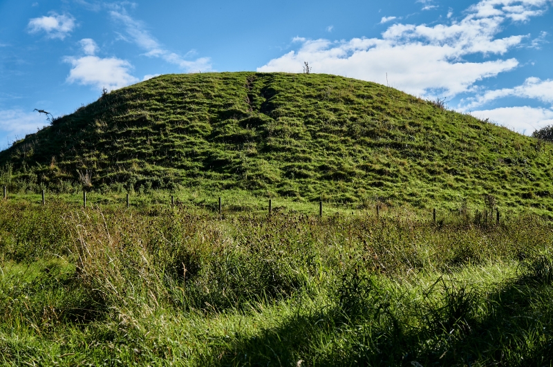
The monument includes the remains of a medieval motte castle, with an
associated bailey or outer enclosure. The castle is situated on a natural hill
defending the crossing of the River Wansbeck and overlooking the town of
Morpeth which both lie to the north. The motte and bailey were created by the
artificial scarping of the north east end of a narrow ridge. The motte is sub-
oval in shape with steep vertical sides to the north, east and west; the
southern side is separated from the bailey or outer enclosure by a steep sided
ditch, up to 3.5m deep. The artificially enhanced motte measures 80m east-west
by 80m north-south, and the natural mound on which it is constructed has
maximum dimensions of 88m north-south by 108m east-west. The northern part of
the summit of the motte has a raised level platform, standing to about 0.2m
high and measuring 16.5m by 17m. Partial excavation in 1830, by William
Woodman, recovered carved stones including scalloped capitals and wedge shaped
arch stones. The foundations of what was interpreted as a long narrow building
were also uncovered. These stone fragments suggest that there was a stone keep
on the motte in the 12th century. The site of a bailey or outer enclosure
occupies the central part of the ridge to the west of the motte. This has also
been created by the artificial scarping of the ridge and its western edge is
defined by a shallow gulley which had been cut across the ridge in a
north-south direction. The western edge of the bailey is enclosed by a bank
2.3m wide and standing up to 0.2m high. The interior of the bailey is
irregular in shape and has maximum dimensions of 40m by 12m. Remains of at
least two internal banks, aligned north-south across the ridge, stand up to
0.35m high.
The castle is believed to have been built by William de Merlay, who was
granted the barony of Morpeth in about 1080. The earliest documentary
reference to the castle is in 1095 when it was captured by William Rufus. It
was burned by King John in 1216 and eventually replaced in the 13th century by
a new castle to the south; this later castle is the subject of a separate
scheduling.
The concrete steps running up the south side of the motte and the stone
retaining wall at the base of the east side are excluded from the scheduling,
although the ground beneath these features is included.
MAP EXTRACT
The site of the monument is shown on the attached map extract.
Source: Historic England
Motte and bailey castles are medieval fortifications introduced into Britain
by the Normans. They comprised a large conical mound of earth or rubble, the
motte, surmounted by a palisade and a stone or timber tower. In a majority of
examples an embanked enclosure containing additional buildings, the bailey,
adjoined the motte. Motte castles and motte-and-bailey castles acted as
garrison forts during offensive military operations, as strongholds, and, in
many cases, as aristocratic residences and as centres of local or royal
administration. Built in towns, villages and open countryside, motte and
bailey castles generally occupied strategic positions dominating their
immediate locality and, as a result, are the most visually impressive
monuments of the early post-Conquest period surviving in the modern landscape.
Over 600 motte castles or motte-and-bailey castles are recorded nationally,
with examples known from most regions. As one of a restricted range of
recognised early post-Conquest monuments, they are particularly important for
the study of Norman Britain and the development of the feudal system. Although
many were occupied for only a short period of time, motte castles continued to
be built and occupied from the 11th to the 13th centuries, after which they
were superseded by other types of castle.
Despite limited excavation in the mid-19th century the motte and bailey castle
on Haw Hill survives reasonably well and retains significant archaeological
deposits. It will contribute to our knowledge and understanding of the Norman
Conquest of northern Britain.
Source: Historic England
Other
NZ 18 NE 5,
Source: Historic England
Other nearby scheduled monuments