Approximate Location Map
Large Map »
This site is entirely user-supported. See how you can help.
Latitude: 52.7861 / 52°47'9"N
Longitude: -2.653 / 2°39'10"W
OS Eastings: 356056.68226
OS Northings: 321147.698277
OS Grid: SJ560211
Mapcode National: GBR 7M.XJ31
Mapcode Global: WH9CM.67XF
Entry Name: Moated site 140m east of St Mary's Church
Scheduled Date: 25 February 1971
Last Amended: 3 April 2000
Source: Historic England
Source ID: 1017238
English Heritage Legacy ID: 32315
County: Shropshire
Civil Parish: Shawbury
Built-Up Area: Shawbury
Traditional County: Shropshire
Lieutenancy Area (Ceremonial County): Shropshire
Church of England Parish: Shawbury St Mary the Virgin
Church of England Diocese: Lichfield
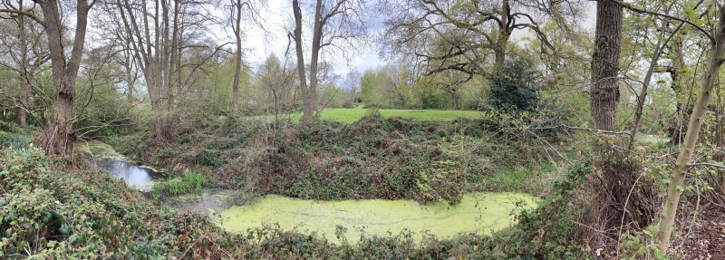
The monument includes the earthwork and buried remains of a medieval moated
site situated on an east facing slope alongside the River Roden, 140m east of
St Mary's Church. The moat defines a rectangular island, which measures
approximately 34m east - west and 43m north - south. The arms of the moat are
between 13m and 17m wide, up to 2m deep, and retain water. Material excavated
from the moat has been used to heighten the eastern portion of island in order
to create a level platform. Spoil from this operation has also been used to
form external banks along the length of the eastern arm and the adjoining
portions of the northern and southern arms. These banks are between 5m and 7m
wide and up to 1.3m in height. In the middle of the western arm there is a
causeway, 6m wide across its top, that provides access to the island.
The modern gate and the fence that partly surrounds the site is excluded from
the scheduling, although the ground beneath these features is included.
MAP EXTRACT
The site of the monument is shown on the attached map extract.
It includes a 2 metre boundary around the archaeological features,
considered to be essential for the monument's support and preservation.
Source: Historic England
Around 6,000 moated sites are known in England. They consist of wide ditches,
often or seasonally water-filled, partly or completely enclosing one or more
islands of dry ground on which stood domestic or religious buildings. In some
cases the islands were used for horticulture. The majority of moated sites
served as prestigious aristocratic and seigneurial residences with the
provision of a moat intended as a status symbol rather than a practical
military defence. The peak period during which moated sites were built was
between about 1250 and 1350 and by far the greatest concentration lies in
central and eastern parts of England. However, moated sites were built
throughout the medieval period, are widely scattered throughout England and
exhibit a high level of diversity in their forms and sizes. They form a
significant class of medieval monument and are important for the understanding
of the distribution of wealth and status in the countryside. Many examples
provide conditions favourable to the survival of organic remains.
The moated site 140m east of St Mary's Church is a well preserved example of
this class of monument. The moated island will retain structural and
artefactual evidence of the buildings that once stood on the site, which
together with the artefacts and organic remains existing in the moat will
provide valuable evidence about the occupation and social status of the
inhabitants. Organic remains surviving in the buried ground surfaces under the
raised interior and the external banks, and in the moat, will also provide
information about the changes to the local environment and use of the land
before and after the moated site was constructed. The importance of the site
is also enhanced by its amenity value. It is accessible to the public and is a
valuable educational resource.
Source: Historic England
Other nearby scheduled monuments