Approximate Location Map
Large Map »
This site is entirely user-supported. See how you can help.
Latitude: 55.117 / 55°7'1"N
Longitude: -2.6684 / 2°40'6"W
OS Eastings: 357462.442787
OS Northings: 580492.628168
OS Grid: NY574804
Mapcode National: GBR 99T8.2H
Mapcode Global: WH7Z1.ZNH3
Entry Name: Ten medieval shielings on north bank of White Lyne overlooking confluence with Little Hare Grain
Scheduled Date: 17 January 1972
Last Amended: 22 December 1997
Source: Historic England
Source ID: 1016404
English Heritage Legacy ID: 27790
County: Cumbria
Civil Parish: Bewcastle
Traditional County: Cumberland
Lieutenancy Area (Ceremonial County): Cumbria
Church of England Parish: Bewcastle St Cuthbert
Church of England Diocese: Carlisle
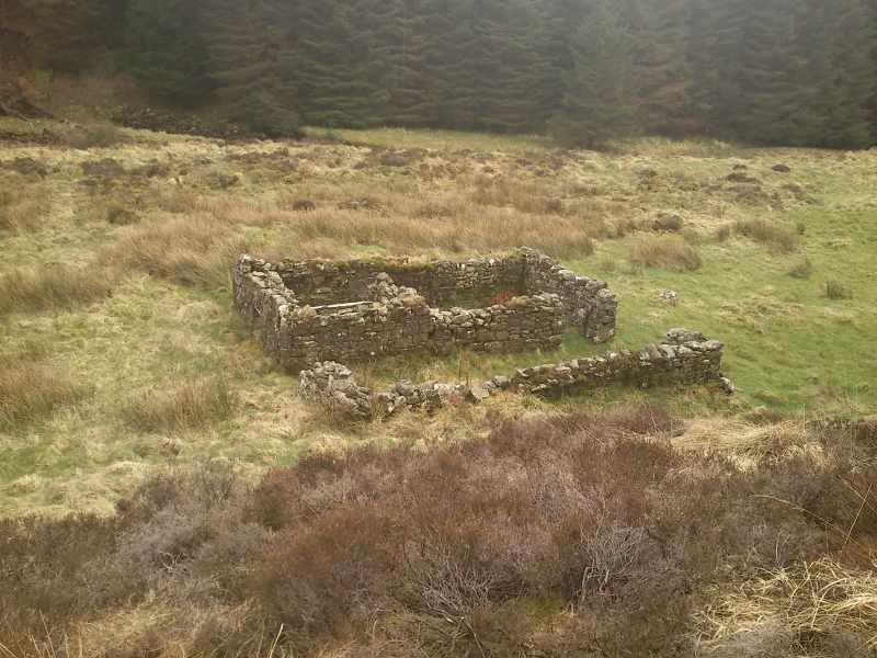
The monument includes the upstanding and buried remains of a group of ten
closely spaced stone built medieval shielings which are located on an area of
boulder strewn flat ground on the north bank of the White Lyne overlooking its
confluence with Little Hare Grain. This group forms part of a larger group of
24 shielings strung out for approximately 800m along the valley floor of the
White Lyne which were surveyed by the Royal Commission on the Historical
Monuments of England in 1970 prior to afforestation of the area. The most
prominent and best preserved shieling in this group of ten measures 8.5m by
4.1m with its long axis aligned east-west and walls up of 1.75 high. It is
divided into two unequal-sized rooms; the main entrance is at the shieling's
north west corner and leads into the larger room which is paved at the
entrance. The smaller room has a raised flagged floor, is entered through a
doorway from the larger room, and was lit by a small window in the south wall.
A low fibrous mound outside the hut to the south east and along the south wall
is a fallen remnant of the turf roof. This shieling and a rectangular
enclosure on its north side, the north wall of the former being common to
both, have latterly been used as a sheepfold. The enclosure stands on the
boulder footings of an earlier shieling which measured 8.4m by 4.1m with its
long axis aligned east-west, and which was robbed to build the later shieling.
Approximately 14m ENE of the well preserved shieling are the boulder footings
of a rectangular shieling measuring 9m by 4m with its long axis aligned east-
west and an entrance in its north side to the west of centre. Some 14.5m south
east of the well preserved shieling, at the edge of a low natural ridge, are
the boulder footings of a rectangular shieling measuring 8.2m by 4.6m with its
long axis aligned north east-south west and an entrance in its south east side
to the west of centre. Approximately 25m south east of the well preserved
shieling are the large boulder footings of a rectangular two roomed shieling
measuring 9.8m by 4.5m with its long axis aligned east-west and an entrance on
the northern side. Ten metres to the south of the well preserved shieling are
the boulder footings of a one roomed small squarish shieling measuring 6.1m by
5.5m with walls up to 1.5m thick and an entrance at the south west corner.
Approximately 23m south of the well preserved shieling are the heather covered
footings of an almost circular one roomed shieling measuring 5.5m by 5.2m with
an entrance on the south west side. Immediately to the west of this shieling
are the heather covered remains of the northern half of a one roomed shieling
measuring 4.6m wide with walls 1.1m wide formed of a boulder outer face,
upright slabs to the inner face and rubble infill. Some 24m ESE of the
well preserved shieling are the heather covered footings of a rectangular
shieling measuring 9.4m by 4.7m with its long axis aligned east-west and an
entrance in the south side west of centre. Approximately 66m ESE of the
well preserved shieling are the boulder walls of a one roomed small squarish
shieling measuring 5.4m by 4.6m with walls up to 1.1m wide and 0.8m high and
an entrance on its north eastern side. Documentary sources indicate that the
Bewcastle Fells were first used by the Lords of Burgh on Solway in the 13th
century to summer their cattle and `build shields and cabins'. This custom
continued into the 17th century. Although none of the shielings here was
occupied in 1754, documentary sources indicate there had been seasonal
occupation in the neighbourhood at that time and this may account for the
presence and relative sophistication of the well preserved shieling.
MAP EXTRACT
The site of the monument is shown on the attached map extract.
It includes a 2 metre boundary around the archaeological features,
considered to be essential for the monument's support and preservation.
Source: Historic England
Shielings are small seasonally occupied huts which were built to provide
shelter for herdsmen who tended animals grazing summer pasture on upland or
marshland. These huts reflect a system called transhumance, whereby stock was
moved in spring from lowland pasture around the permanently occupied farms to
communal upland grazing during the warmer summer months. Settlement patterns
reflecting transhumance are known from the Bronze Age (c.2000-700 BC)
onwards. However, the construction of herdsmen's huts in a form distinctive
from the normal dwelling houses of farms, only appears from the early medieval
period onwards (from AD 450), when the practice of transhumance is also known
from documentary sources and, notably, place-name studies. Their construction
appears to cease at the end of the 16th century. Shielings vary in size but
are commonly small and may occur singly or in groups. They have a simple sub-
rectangular or ovoid plan normally defined by drystone walling, although
occasional turf-built structures are known, and the huts are sometimes
surrounded by a ditch. Most examples have a single undivided interior but two
roomed examples are known. Some examples have adjacent ancillary structures,
such as pens, and may be associated with a midden. Some are also contained
within a small ovoid enclosure. Shielings are reasonably common in the uplands
but frequently represent the only evidence for medieval settlement and farming
practice here. Those examples which survive well and which help illustrate
medieval land use in an area are considered to be nationally important.
The ten medieval shielings on the north bank of the White Lyne overlooking its
confluence with Little Hare Grain survive reasonably well and are part of a
larger group of shielings sited amongst the uplands and along the river
valleys and tributaries of north east Cumbria which, taken together, will add
to our knowledge and understanding of the wider border settlement and economy
during the medieval period. Additionally this group of shielings is a rare
example of different types of shielings occupying the same site, and as such
will facilitate any further study of the developments in the construction of
shielings throughout the medieval period.
Source: Historic England
Books and journals
Ramm, H G , Shielings and Bastles, (1970), 18-31
'Gentleman's Magazine' in Gentleman's Magazine, (1754), 505-6
'Gentleman's Magazine' in Gentleman's Magazine, (1754), 505-6
'Gentleman's Magazine' in Gentleman's Magazine, (1754), 505-6
'Gentleman's Magazine' in Gentleman's Magazine, (1754), 505-6
Denton, J, 'C&WAAS Tract Ser' in Accompot of the Most Consid Estates & Families in Cumberland, , Vol. II, (1887), 146
Denton, J, 'C&WAAS Tract Ser' in Accompot of the Most Consid Estates & Families in Cumberland, , Vol. II, (1887), 146
Denton, J, 'C&WAAS Tract Ser' in Accompot of the Most Consid Estates & Families in Cumberland, , Vol. II, (1887), 146
Denton, J, 'C&WAAS Tract Ser' in Accompot of the Most Consid Estates & Families in Cumberland, , Vol. II, (1887), 146
Denton, J, 'C&WAAS Tract Ser' in Accompot of the Most Consid Estates & Families in Cumberland, , Vol. II, (1887), 146
Denton, J, 'C&WAAS Tract Ser' in Accompot of the Most Consid Estates & Families in Cumberland, , Vol. II, (1887), 146
Denton, J, 'C&WAAS Tract Ser' in Accompot of the Most Consid Estates & Families in Cumberland, , Vol. II, (1887), 146
Other
Schofield,A.J., MPP Single Monument Class Descriptions - Shielings, (1989)
Schofield,A.J., MPP Single Monument Class Descriptions - Shielings, (1989)
Schofield,A.J., MPP Single Monument Class Descriptions - Shielings, (1989)
Source: Historic England
Other nearby scheduled monuments